


In summer 2025, NASA’s ER-2 high-altitude aircraft flew over broad swaths of the western United States, collecting data for the multi-year Geological Earth Mapping Experiment (GEMx). In this experiment, a joint effort between NASA and the U.S. Geological Survey, sophisticated instruments mounted on the aircraft were mapping land across the West in fine spectral detail to identify deposits of critical minerals. Then, in late July, scientific opportunity arose as two major wildland fires raged in southwestern states.
At the time, the Monroe Canyon and Dragon Bravo fires were growing rapidly to consume tens of thousands of acres in Utah and Arizona, respectively. Both fires were burning in areas slated for mapping during the summer’s GEMx airborne campaign. Given this overlap, scientists saw a unique opportunity for collaboration between GEMx and FireSense, a NASA project that leverages the agency’s technical capabilities to support wildland fire management.
“GEMx and FireSense have been working together closely for the past year to understand the capabilities of each mission and to determine how we can aid each other,” said Kevin Reath, NASA deputy program manager for GEMx. Taking advantage of cloud-free conditions over the fires, GEMx capitalized on ER-2 flights in nearby smoke-free areas upwind to gain novel views of two active wildfires, as well as to collect mineralogy data per GEMx campaign plans.
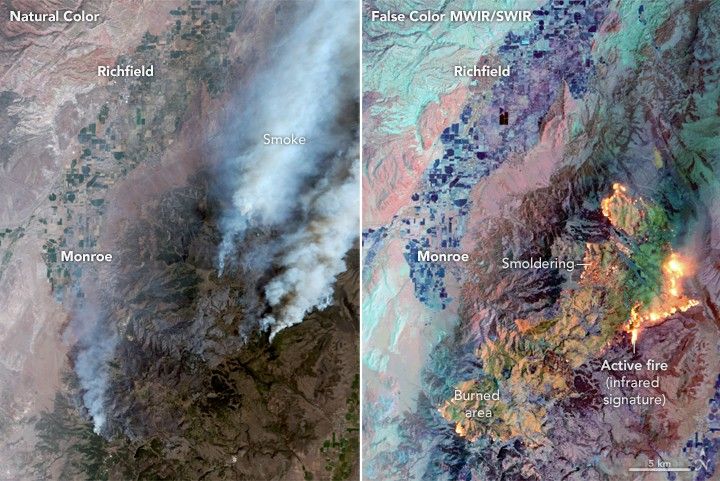
Data captured during one of the flights over the Monroe Canyon fire are shown above. The MASTER (MODIS/ASTER Airborne Simulator) instrument acquired these images on July 30 at about 11:30 a.m. local time. The false-color image (right) combines three midwave and shortwave infrared (MWIR and SWIR) wavelengths—4.05, 2.16, and 1.60 micrometers—to see through smoke plumes and identify the relative intensity of burning. Active fire appears bright orange, recently burned areas are yellow-green, and live vegetation displays in shades of purple and dark blue. The left image is natural color, which resembles what the human eye would see.
MASTER’s infrared observations are useful for determining the maximum temperature in a fire and understanding how it might behave, said Jacquelyn Shuman, a forest ecologist at NASA’s Ames Research Center and project scientist for FireSense. “Knowing how hot a fire is can tell you how high the smoke can go, how fast the fire can move, and how big it can be,” she said.
The MASTER instrument can also distinguish between flaming and smoldering areas, which can inform firefighters of hot spots to keep an eye on. The Monroe Canyon data were not used to support firefighting operations, Shuman said, although responders have used similar airborne observations in near real time during other fires. Also operating on these flights, the AVIRIS-5 (Airborne Visible/Infrared Imaging Spectrometer-5) instrument collected measurements in hundreds of spectral bands. The two instruments are complementary, said Shuman, with AVIRIS excelling at determining the fire perimeter.
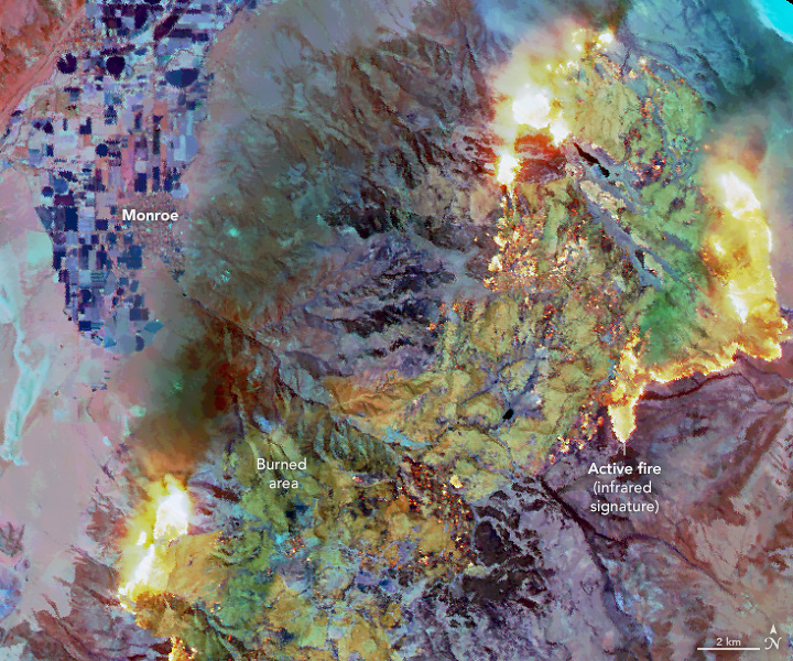
July 30 was an active day for the Monroe Canyon fire. The image above, acquired during a second overpass at about 3 p.m., shows how the fire intensified along parts of its perimeter. Fire managers reported that inversions had been lifting around midday each day, allowing for increased airflow into the fire. Conditions on July 30 included high temperatures, humidity around 5 percent, and wind gusts up to 36 miles (58 kilometers) per hour.
Scattered pyrocumulus clouds, formed by updrafts from the fire’s heat, were observed later in the afternoon, said Dave Peterson, meteorologist with the U.S. Naval Research Laboratory. Peterson is also the principal investigator of the INjected Smoke and PYRocumulonimbus Experiment (INSPYRE) mission, which will investigate the types of fire behavior that produce pyrocumulus and pyrocumulonimbus (pyroCb) clouds.
“It’s commonly assumed that fires triggering pyroCb development are large and intense,” he said. “But we still don’t know: How large? How intense?” Seeking answers to these questions and others, INSPYRE will collect MASTER observations of fires like Monroe Canyon at intervals as short as 20 minutes.
As for the GEMx mission, data from the Monroe Canyon and Dragon Bravo fires will bring a novel perspective to another ongoing field of research: how fire affects the spectral signatures of surface minerals. “By collecting these data, we will further this research and be able to better characterize minerals on the surface in recently burned areas,” Reath said. Improving surface mineral maps with cutting-edge geoscience data is one of the goals of the USGS Earth Mapping Resources Initiative, which funds GEMx.
Scientists for both GEMx and FireSense believe that their newfound symbiosis could lead to new knowledge about mineral discovery and improve the use of MASTER and AVIRIS sensors for fire management. “This will likely be the best imagery of naturally caused wildfires we have to date,” Reath said, “and represents a success for both missions.”
References & Resources
- InciWeb (2025, August) Monroe Canyon Fire. Accessed August 14, 2025.
- MASTER (2025) Campaign Summary Information: GEMx 2025. Accessed August 14, 2025.
- NASA FireSense Project. Accessed August 14, 2025.
- NASA (2023, November 7) NASA Maps Minerals and Ecosystem Function in Southwest U.S. Regions. Accessed August 14, 2025.
- NASA Earth Observatory (2025, August 1) Monroe Canyon Fire Intensifies. Accessed August 14, 2025.
- NASA Earth Science Project Office INjected Smoke and PYRocumulonimbus Experiment. Accessed August 14, 2025.
- U.S. Geological Survey Earth Mapping Resources Initiative (Earth MRI). Accessed August 14, 2025.
MASTER images by RoseAnne Dominguez ( Airborne Sensor Facility ), annotated by Lauren Dauphin. Story by Lindsey Doermann .


