


Description
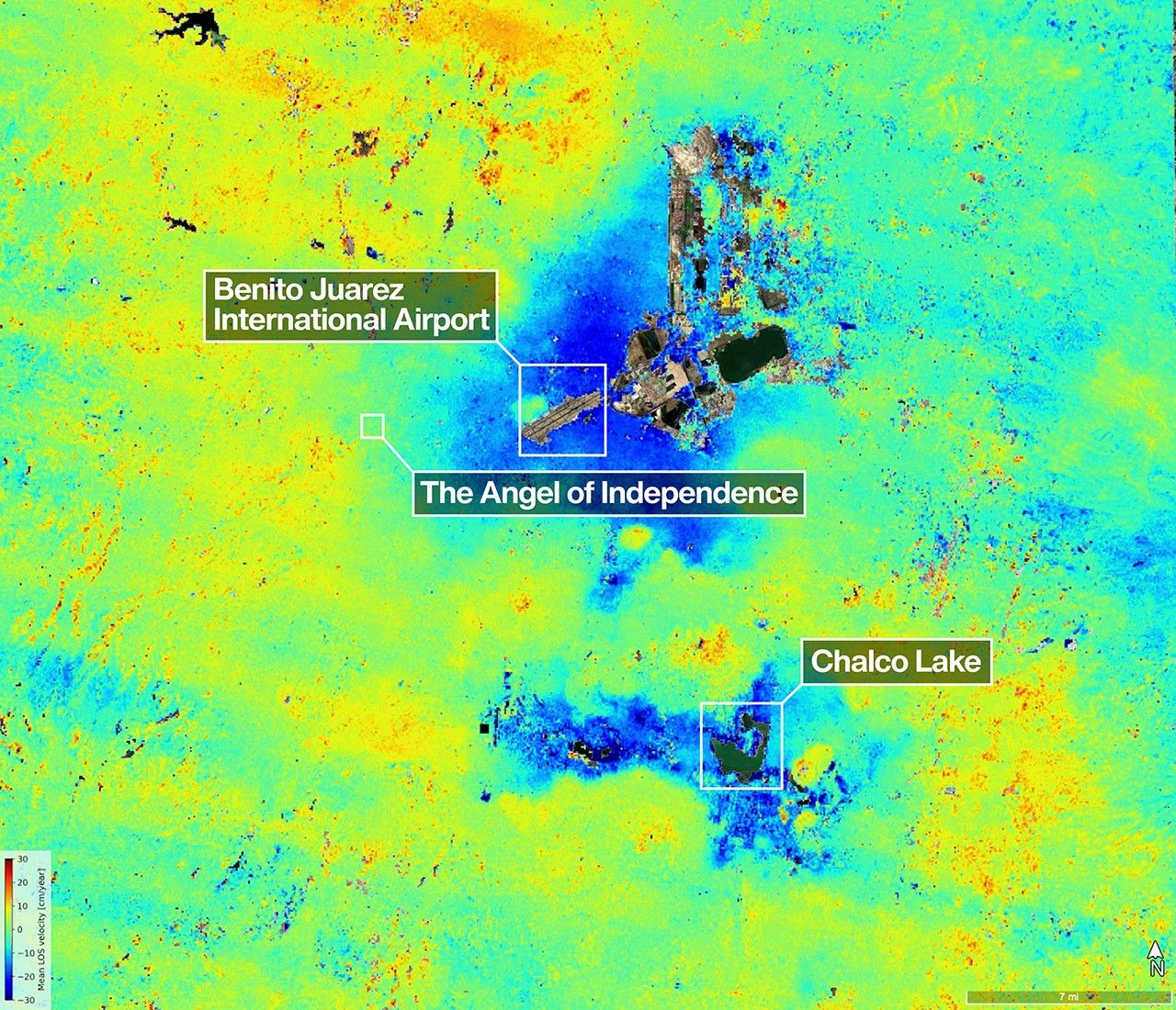
A scientist produced this map of land subsidence (sinking) in Mexico City using data from the NISAR (NASA-ISRO Synthetic Aperture Radar) mission captured between Oct. 25, 2025, and Jan. 17, 2026. The region has been a well-known hot spot of subsidence for decades, and images like this help confirm that NISAR is performing as expected in its first year of operation.
The dark blue color indicates areas found to be subsiding by more than half an inch (more than 2 centimeters) per month, due in large part to groundwater pumping, which has led to compaction of the dry, ancient lakebed on which the city was built. The yellow and red areas are likely residual noise signals that are expected to decrease as NISAR collects more data and refines its measurements.
Two marshy ecosystems with ties to the country’s past can be seen in the image. The dark green oblong to the northeast of the airport is Nabor Carrillo, an artificial lake constructed over the now-extinct Lake Texcoco. Chalco Lake, a wetland located in a historically fertile region to the south, shares its name with a major body of water that was drained over a period of centuries to reduce flooding in the city. The ancient lake was a primary natural habitat of the Mexican Axolotl, an endangered species of salamander with the ability to regrow limbs.
Another landmark pinpointed in the image — the Angel of Independence along the Paseo de la Reforma — was built in 1910 to commemorate 100 years of Mexico’s independence. Standing over 100 feet (30 meters) tall, the monument has had 14 steps added to its base over the years as the land around it has gradually sunk.

Figure A is a version of the image extending further south and with no labels, scale, or compass.
The images were created with data from NISAR’s L-band radar instrument, which uses a 9-inch (24-centimeter) wavelength that enables its signal to penetrate dense vegetation such as forest canopies.
The satellite’s S-band radar, provided by the Indian Space Research Organisation’s Space Applications Centre, uses a 4-inch (10-centimeter) microwave signal that’s more sensitive to small vegetation, which makes it effective at monitoring certain types of agriculture and grassland ecosystems. Launched in 2025, NISAR is the first satellite to carry two SAR instruments at different wavelengths.
Data from NISAR will benefit humanity by helping researchers around the world better understand changes across our planet’s surface, from cities to forests and glaciers. The global and rapid coverage from NISAR will also provide unprecedented support for disaster response, producing data to assist in mitigating and assessing damage, with observations before and after catastrophic events available in short time frames.
Find more information about NISAR here: https://science.nasa.gov/mission/nisar/


