


before
after
Extremely hot, dry weather in southern Australia has led to a number of brush fires. On the island of Tasmania, south of the Australian continent, more than 148,000 acres burned during the first half of January 2013. Losses reached $43 million and were predicted to exceed $100 million. In the township of Dunalley, over 40 percent of the structures have been destroyed. No deaths have been reported as of mid-January, but more than 100 people have been listed as missing. The 2012 image shows normal conditions; the 2013 image shows the burned areas and smoke rising from active fires in the upper right area. Images taken by the Enhanced Thematic Mapper Plus sensor onboard Landsat 7. Source: U.S. Geological Survey (USGS) Landsat Missions Gallery, "Brush Fires in Tasmania," U.S. Department of the Interior / USGS and NASA.

Extremely hot, dry weather in southern Australia has led to a number of brush fires. On the island of Tasmania, south of the Australian continent, more than 148,000 acres burned during the first half of January 2013. Losses reached $43 million and were predicted to exceed $100 million. In the township of Dunalley, over 40 percent of the structures have been destroyed. No deaths have been reported as of mid-January, but more than 100 people have been listed as missing. The 2012 image shows normal conditions; the 2013 image shows the burned areas and smoke rising from active fires in the upper right area. Images taken by the Enhanced Thematic Mapper Plus sensor onboard Landsat 7. Source: U.S. Geological Survey (USGS) Landsat Missions Gallery, "Brush Fires in Tasmania," U.S. Department of the Interior / USGS and NASA.
Extremely hot, dry weather in southern Australia has led to a number of brush fires. On the island of Tasmania, south of the Australian continent, more than 148,000 acres burned during the first half of January 2013. Losses reached $43 million and were predicted to exceed $100 million. In the township of Dunalley, over 40 percent of the structures have been destroyed. No deaths have been reported as of mid-January, but more than 100 people have been listed as missing. The 2012 image shows normal conditions; the 2013 image shows the burned areas and smoke rising from active fires in the upper right area. Images taken by the Enhanced Thematic Mapper Plus sensor onboard Landsat 7. Source: U.S. Geological Survey (USGS) Landsat Missions Gallery, "Brush Fires in Tasmania," U.S. Department of the Interior / USGS and NASA.
Extremely hot, dry weather in southern Australia has led to a number of brush fires. On the island of Tasmania, south of the Australian continent, more than 148,000 acres burned during the first half of January 2013. Losses reached $43 million and were predicted to exceed $100 million. In the township of Dunalley, over 40 percent of the structures have been destroyed. No deaths have been reported as of mid-January, but more than 100 people have been listed as missing. The 2012 image shows normal conditions; the 2013 image shows the burned areas and smoke rising from active fires in the upper right area. Images taken by the Enhanced Thematic Mapper Plus sensor onboard Landsat 7. Source: U.S. Geological Survey (USGS) Landsat Missions Gallery, "Brush Fires in Tasmania," U.S. Department of the Interior / USGS and NASA.
before
after
Before and After
Tasmania Fire, Australia
February 3, 2012 - January 4, 2013
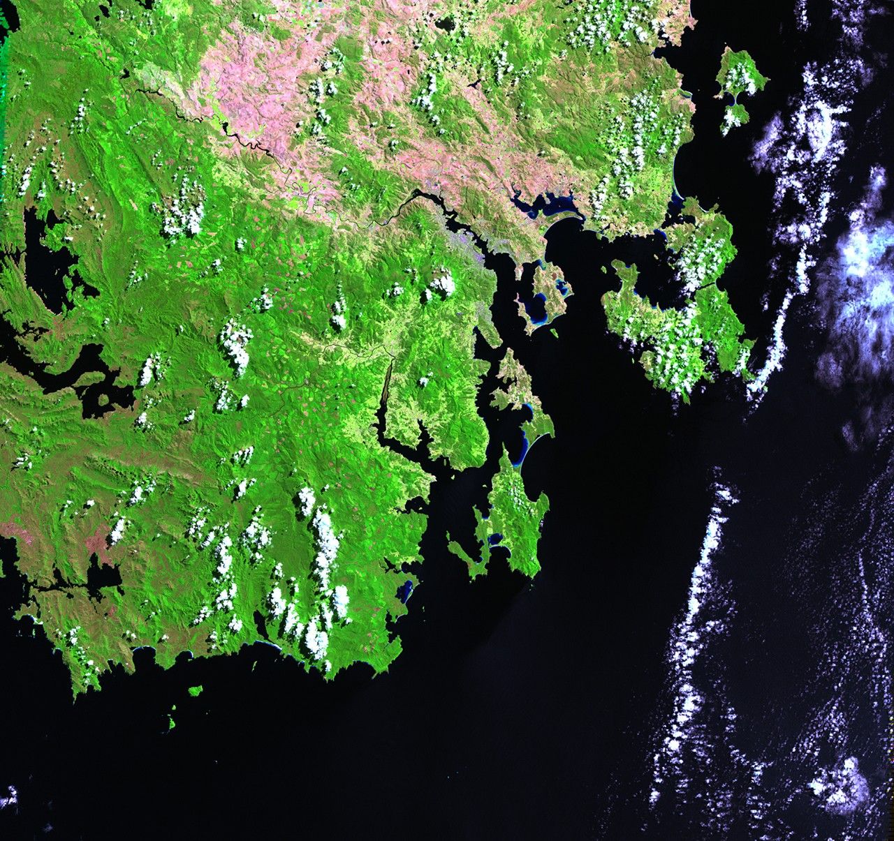
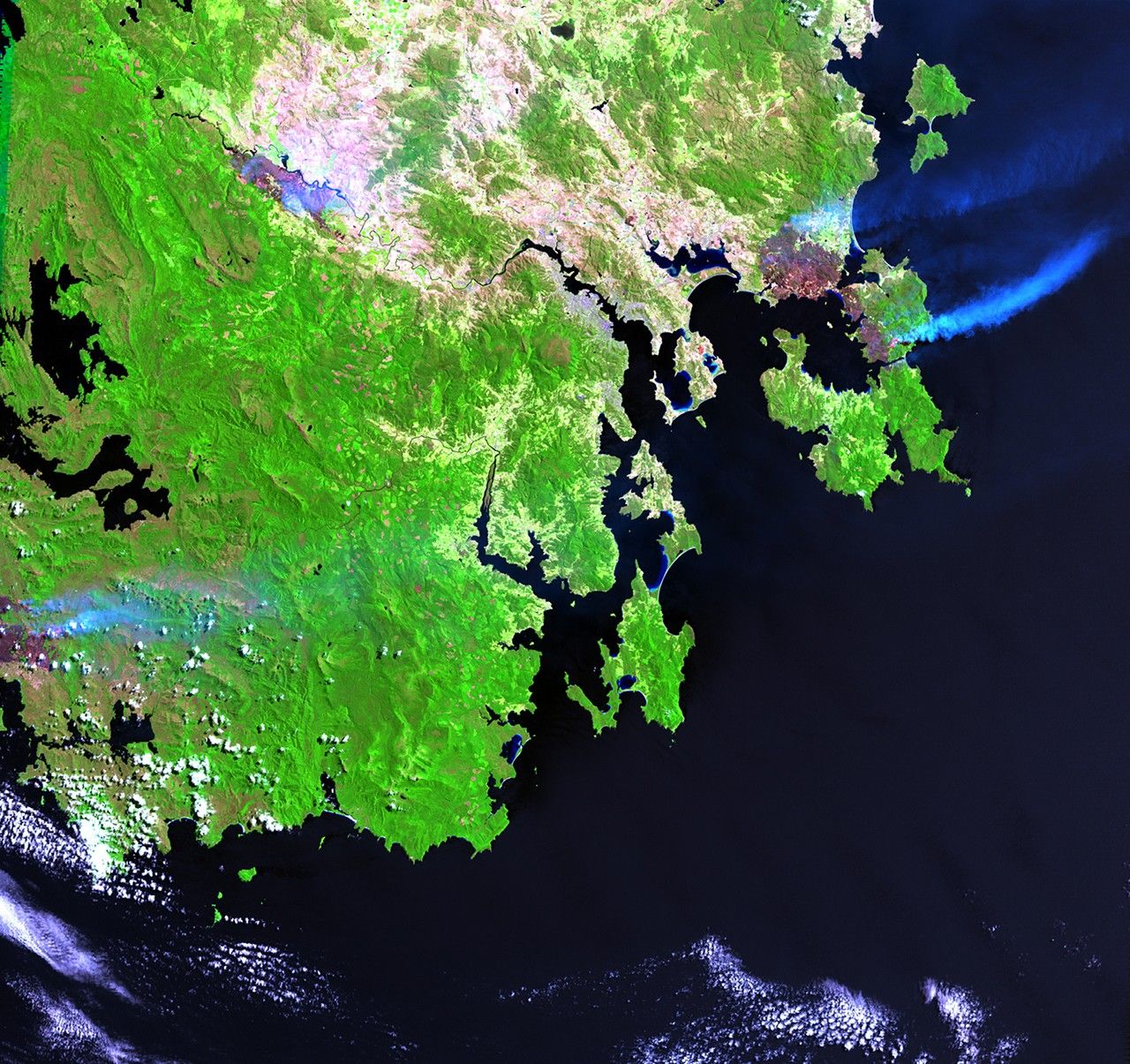
Extremely hot, dry weather in southern Australia has led to a number of brush fires. On the island of Tasmania, south of the Australian continent, more than 148,000 acres burned during the first half of January 2013. Losses reached $43 million and were predicted to exceed $100 million. In the township of Dunalley, over 40 percent of the structures have been destroyed. No deaths have been reported as of mid-January, but more than 100 people have been listed as missing. The 2012 image shows normal conditions; the 2013 image shows the burned areas and smoke rising from active fires in the upper right area. Images taken by the Enhanced Thematic Mapper Plus sensor onboard Landsat 7. Source: U.S. Geological Survey (USGS) Landsat Missions Gallery, "Brush Fires in Tasmania," U.S. Department of the Interior / USGS and NASA.


