


before
after

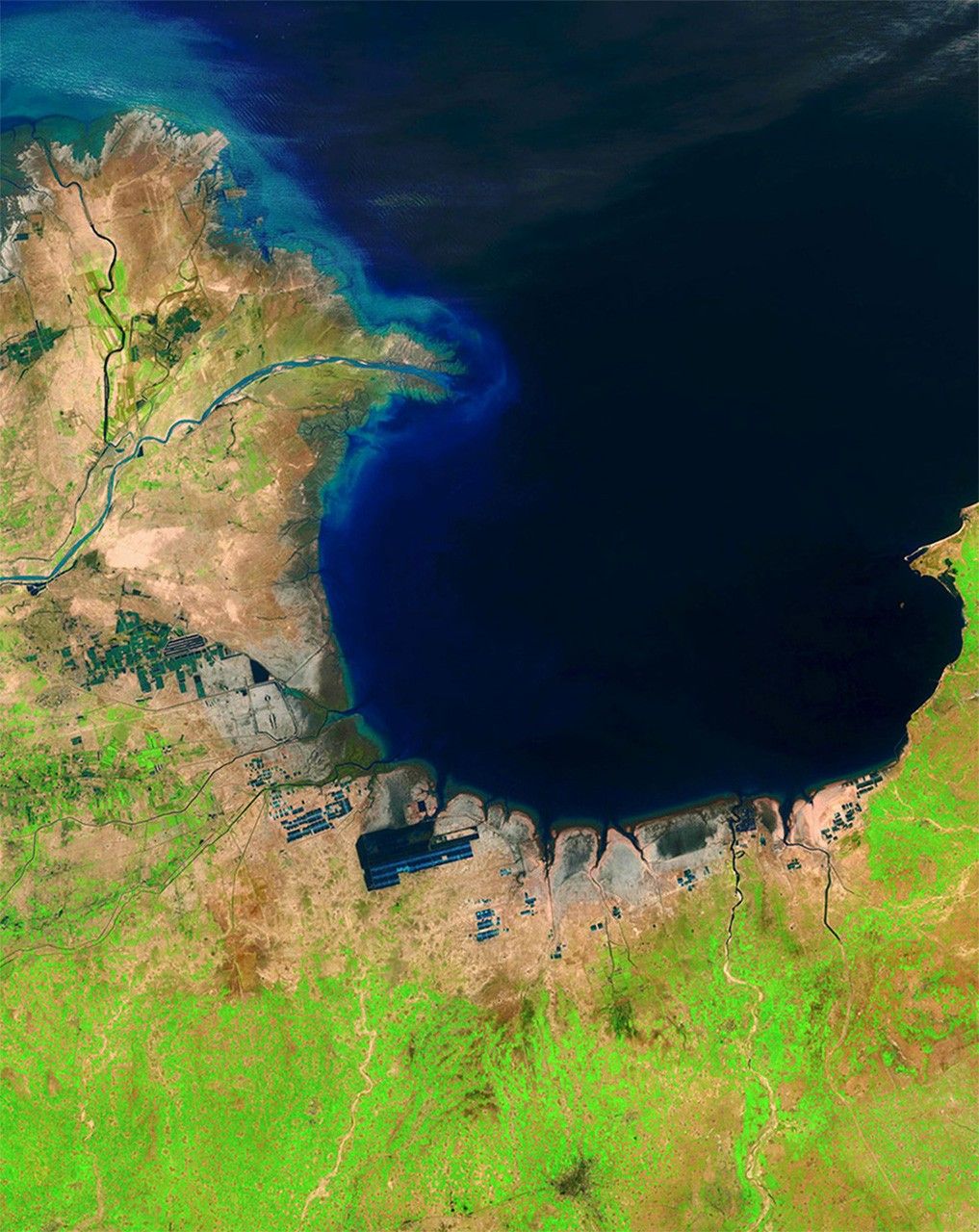
China's Huang He (Yellow) River is the most sediment-filled river on Earth. Each year, it transports millions of tons of soil from a plateau it crosses to a delta it has built in the Bohai Sea. These images show the delta's growth from 1985 to 2014. The latter image also shows another change: ponds that hold shrimp and other seafood (seen here as dark geometric shapes along the coastline) were built on what were once tidal flats. Images taken by the Thematic Mapper onboard Landsat 5 and the Operational Land Imager onboard Landsat 8. Source: U.S. Geological Survey (USGS) Landsat Missions Gallery "Huang He Delta and Lauzhou Bay," U.S. Department of the Interior / USGS and NASA.
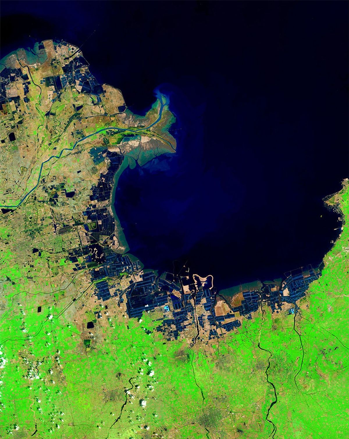
China's Huang He (Yellow) River is the most sediment-filled river on Earth. Each year, it transports millions of tons of soil from a plateau it crosses to a delta it has built in the Bohai Sea. These images show the delta's growth from 1985 to 2014. The latter image also shows another change: ponds that hold shrimp and other seafood (seen here as dark geometric shapes along the coastline) were built on what were once tidal flats. Images taken by the Thematic Mapper onboard Landsat 5 and the Operational Land Imager onboard Landsat 8. Source: U.S. Geological Survey (USGS) Landsat Missions Gallery "Huang He Delta and Lauzhou Bay," U.S. Department of the Interior / USGS and NASA.
China's Huang He (Yellow) River is the most sediment-filled river on Earth. Each year, it transports millions of tons of soil from a plateau it crosses to a delta it has built in the Bohai Sea. These images show the delta's growth from 1985 to 2014. The latter image also shows another change: ponds that hold shrimp and other seafood (seen here as dark geometric shapes along the coastline) were built on what were once tidal flats. Images taken by the Thematic Mapper onboard Landsat 5 and the Operational Land Imager onboard Landsat 8. Source: U.S. Geological Survey (USGS) Landsat Missions Gallery "Huang He Delta and Lauzhou Bay," U.S. Department of the Interior / USGS and NASA.
China's Huang He (Yellow) River is the most sediment-filled river on Earth. Each year, it transports millions of tons of soil from a plateau it crosses to a delta it has built in the Bohai Sea. These images show the delta's growth from 1985 to 2014. The latter image also shows another change: ponds that hold shrimp and other seafood (seen here as dark geometric shapes along the coastline) were built on what were once tidal flats. Images taken by the Thematic Mapper onboard Landsat 5 and the Operational Land Imager onboard Landsat 8. Source: U.S. Geological Survey (USGS) Landsat Missions Gallery "Huang He Delta and Lauzhou Bay," U.S. Department of the Interior / USGS and NASA.
before
after
Before and After
Huang He (Yellow) delta growth, China
May 1, 1985 - May 1, 2014
China's Huang He (Yellow) River is the most sediment-filled river on Earth. Each year, it transports millions of tons of soil from a plateau it crosses to a delta it has built in the Bohai Sea. These images show the delta's growth from 1985 to 2014. The latter image also shows another change: ponds that hold shrimp and other seafood (seen here as dark geometric shapes along the coastline) were built on what were once tidal flats. Images taken by the Thematic Mapper onboard Landsat 5 and the Operational Land Imager onboard Landsat 8. Source: U.S. Geological Survey (USGS) Landsat Missions Gallery "Huang He Delta and Lauzhou Bay," U.S. Department of the Interior / USGS and NASA.


