


![Request for Information – Potential [Placeholder for Prize]](https://assets.science.nasa.gov/dynamicimage/assets/science/psd/solar/2023/09/s/solarsystem_0.jpg?w=1024)


before
after

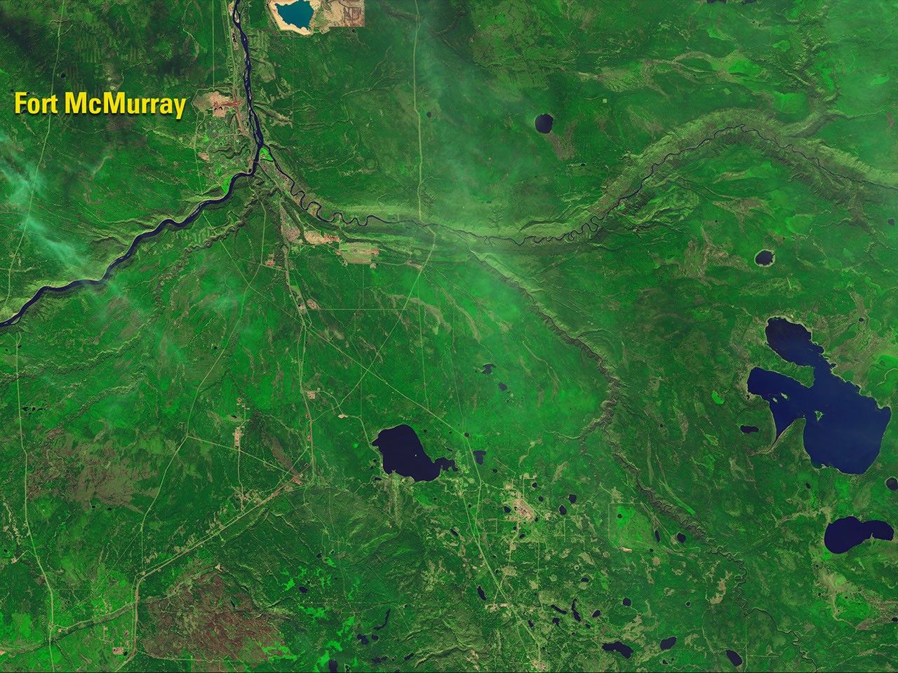
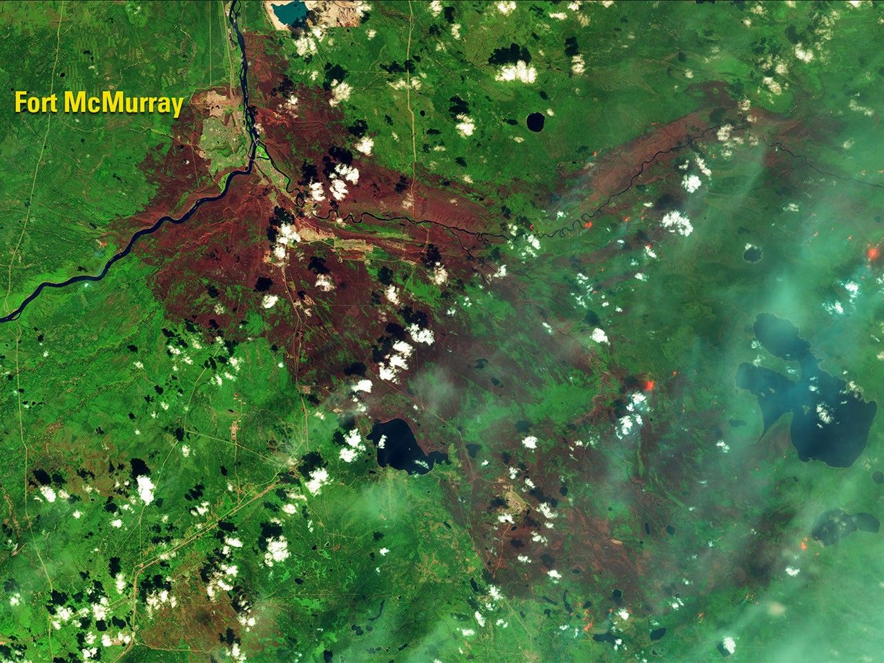
The Fort McMurray wildfire, one of the most destructive in Canada’s history, has burned some 600,000 acres, including nearly 10 percent of the city. In the 2016 false-color image, blue haze indicates smoke, bright orange shows active fires and the reddish-brown areas are burn scars. Fire destroyed more than 2,400 structures and damaged at least 500 more. See also this account. Images taken by the Operational Land Imager onboard Landsat 8. Source: U.S. Geological Survey (USGS) Landsat Missions Gallery; “Landsat 8 Shows Burn Extent, Active Fire at Fort McMurray;” U.S. Department of the Interior / USGS and NASA.

The Fort McMurray wildfire, one of the most destructive in Canada’s history, has burned some 600,000 acres, including nearly 10 percent of the city. In the 2016 false-color image, blue haze indicates smoke, bright orange shows active fires and the reddish-brown areas are burn scars. Fire destroyed more than 2,400 structures and damaged at least 500 more. See also this account. Images taken by the Operational Land Imager onboard Landsat 8. Source: U.S. Geological Survey (USGS) Landsat Missions Gallery; “Landsat 8 Shows Burn Extent, Active Fire at Fort McMurray;” U.S. Department of the Interior / USGS and NASA.
The Fort McMurray wildfire, one of the most destructive in Canada’s history, has burned some 600,000 acres, including nearly 10 percent of the city. In the 2016 false-color image, blue haze indicates smoke, bright orange shows active fires and the reddish-brown areas are burn scars. Fire destroyed more than 2,400 structures and damaged at least 500 more. See also this account. Images taken by the Operational Land Imager onboard Landsat 8. Source: U.S. Geological Survey (USGS) Landsat Missions Gallery; “Landsat 8 Shows Burn Extent, Active Fire at Fort McMurray;” U.S. Department of the Interior / USGS and NASA.
The Fort McMurray wildfire, one of the most destructive in Canada’s history, has burned some 600,000 acres, including nearly 10 percent of the city. In the 2016 false-color image, blue haze indicates smoke, bright orange shows active fires and the reddish-brown areas are burn scars. Fire destroyed more than 2,400 structures and damaged at least 500 more. See also this account. Images taken by the Operational Land Imager onboard Landsat 8. Source: U.S. Geological Survey (USGS) Landsat Missions Gallery; “Landsat 8 Shows Burn Extent, Active Fire at Fort McMurray;” U.S. Department of the Interior / USGS and NASA.
before
after
Before and After
Fort McMurray wildfire aftermath in Alberta, Canada
October 17, 2015 - May 12, 2016
The Fort McMurray wildfire, one of the most destructive in Canada’s history, has burned some 600,000 acres, including nearly 10 percent of the city. In the 2016 false-color image, blue haze indicates smoke, bright orange shows active fires and the reddish-brown areas are burn scars. Fire destroyed more than 2,400 structures and damaged at least 500 more. See also this account. Images taken by the Operational Land Imager onboard Landsat 8. Source: U.S. Geological Survey (USGS) Landsat Missions Gallery; “Landsat 8 Shows Burn Extent, Active Fire at Fort McMurray;” U.S. Department of the Interior / USGS and NASA


