


Even though Curiosity did not drive the planned 15 meters yesterday evening (she only made it about 11 meters), she moved far enough down the road to get in good position to acquire a full high-resolution mosaic of Vera Rubin Ridge (VRR) over the weekend, which was the hope for yesterday's drive. In addition, Curiosity parked herself in a nice sandy location where we can continue to investigate sand ripples on our way towards the ridge. Today, the science team planned a full weekend of scientific investigations and data collection.
ChemCam will kick off this weekend's science plan by investigating the chemistry of two of the few rocky targets in front of the rover: "Zephyr Ledges," the multi-toned flaky patch of rocky material surrounded by sand ripples, and "Wallace Ledge," which is a more massive piece of rock a bit further from the rover. Following these chemistry measurements, Mastcam will be used to document these two rocky targets, including a multispectral observation of "Zephyr Ledges" and the surrounding sands. Multispectral observations collect images at more wavelengths than our eyes are accustomed to viewing, which allows us to detect "color" variations that help us to decipher the composition of these different materials. ChemCam will also collect a high-resolution image mosaic of VRR from this location before Sol 1790's first block of scientific investigations is completed. The second science block of Sol 1790 will be dedicated exclusively to collecting a twelve image mosaic of VRR using Mastcam. As mentioned in yesterday's mission update, these mosaics are essential to understand the structure of the ridge as can be seen from this perspective. Once we are up on VRR itself, we will be unable to see these subsurface layers in the same context.
Late in the afternoon on Sol 1790, Curiosity will unfurl her arm and will begin a chemistry analysis of a sand ripple named "The Shivers" using the Alpha Particle X-Ray Spectrometer (APXS) instrument. This measurement will last several hours, as the X-rays and alpha particles are generated by the slow radioactive decay of curium within the instrument. The longer the APXS is put in contact with a sample of interest, the more precise the chemical measurement will be. Following the measurement of "The Shivers," the APXS will then be moved to another sand ripple target known as "Trumpet," where it will remain overnight to collect several additional hours of chemical analyses. As has been commonly seen in Gale crater, sand ripples exhibit differences in both color and grain size, even over very short distances. These variations provide really valuable information about wind patterns, the size of particles that can be moved by the wind, and whether there is any difference in composition between sediments of different grain sizes. Both "The Shivers" and "Trumpet" exhibit such differences in color and grain size, which is why they are targets of investigation for this weekend's science plan.
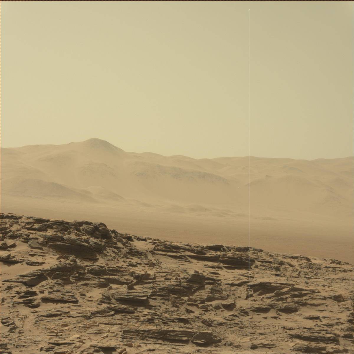
On Sol 1791, Curiosity will focus on monitoring the local environment in Gale crater. Standard measurements of the local weather and radiation environment will be made, as well as passive sky observations using ChemCam. Mastcam will be employed to image the distant rim of Gale crater, as a means of determining how dusty the martian atmosphere is on this day. These measurements are extremely valuable for several reasons, including understanding whether the martian atmosphere will hinder our ability to study the surface both from the ground and from orbit. As a brief demonstration of just how big of an influence dust in Mars' atmosphere can have on imaging at long distances, consider these two images,
<!-- wp:image {"background": {"contentType": "image", "id": 357249, "url": "https://science.nasa.gov/wp-content/uploads/2024/03/1331ML0063910000600018E01_DXXX.jpg", "alt": "", "caption": "This image was taken by Mastcam: Left (MAST_LEFT) onboard NASA's Mars rover Curiosity on Sol 1331 (2016-05-04 17:52:25 UTC). Image", "credits": "NASA/JPL-Caltech/MSSS", "zoom": 0, "fit": "fit", "parallax": "no", "focalPoint": {"x": ".50", "y": ".50"}}, "image_align": "inline", "migrated": true} -->
and the
. Both of these images are looking at the same location on the rim of Gale crater, and they highlight just how variable the Martian atmosphere can be. This is why constant dust monitoring is an important aspect of the Curiosity mission. Before Curiosity eventually stows her arm from the previous evening's APXS measurements, the Mars Hand Lens Imager (MAHLI) will be used to collect very high resolution images of these targets for documentation purposes and to further investigate grain size variations.
On Sol 1792, Curiosity will head off on a planned 40 meter drive to the east-southeast along the planned VRR ascent route. After the drive, she will acquire Navcam and Mascam images of her immediate surroundings for the science team to use in their planning efforts on Monday morning. As always, the Mars Descent Imager (MARDI) will also acquire an image from below the rover.
Thinking back to the two rocky targets being investigated on the first day of this weekend plan, "Zephyr Ledges" and "Wallace Ledge," I can't help but think of how perfect these names are at this stage of the mission. On Earth, these two names correspond to shallow sand bars off the east coast of Maine, in the shallow ocean near more prominent islands that rise above the water. As Curiosity is starting to make preparations to ascend VRR, you can imagine the shallow sand sea that Curiosity is currently exploring and looking up towards the more prominent ridge just to the south. Take away the mighty Atlantic Ocean, and I wouldn't be surprised if the hike from one of these shallow sand bars up to a nearby island doesn't feel similar to Curiosity's upcoming ascent from the lower Murray formation up into Vera Rubin Ridge.
Written by Mark Salvatore, Planetary Geologist at University of Michigan