


before
after
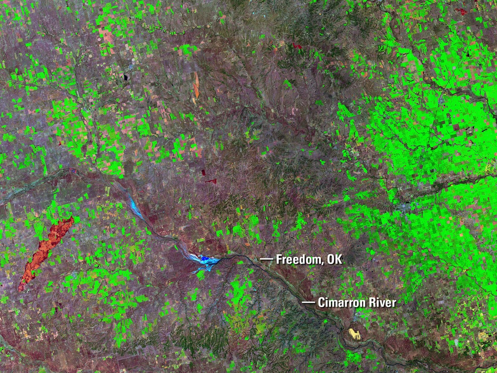
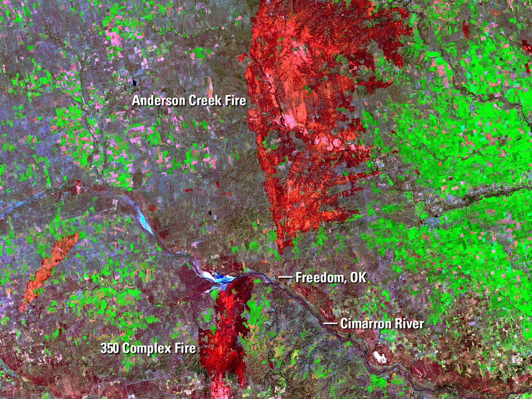
On April 5, 2016, four fires sparked by downed power lines merged and burned almost 57,500 acres near Freedom, OK, in three days. In late March, the Anderson Creek Fire started in Oklahoma and spread into Kansas, burning almost 400,000 acres and becoming the largest blaze ever in the latter state. The red areas in the April image are burn scars from the fires. In both images, a minor scar from an earlier fire appears orange. As of April 8, the National Interagency Fire Center in Boise, Idaho, reported that 817,480 acres had burned year-to-date across the country, the largest tally in that time frame since 2006. Images taken by the Operational Land Imager onboard Landsat 8 and the Enhanced Thematic Mapper Plus onboard Landsat 7. Source: U.S. Geological Survey (USGS) Landsat Missions Gallery; Wildfires Scorch Large Swaths Along Oklahoma-Kansas border; U.S. Department of the Interior / USGS and NASA.
On April 5, 2016, four fires sparked by downed power lines merged and burned almost 57,500 acres near Freedom, OK, in three days. In late March, the Anderson Creek Fire started in Oklahoma and spread into Kansas, burning almost 400,000 acres and becoming the largest blaze ever in the latter state. The red areas in the April image are burn scars from the fires. In both images, a minor scar from an earlier fire appears orange. As of April 8, the National Interagency Fire Center in Boise, Idaho, reported that 817,480 acres had burned year-to-date across the country, the largest tally in that time frame since 2006. Images taken by the Operational Land Imager onboard Landsat 8 and the Enhanced Thematic Mapper Plus onboard Landsat 7. Source: U.S. Geological Survey (USGS) Landsat Missions Gallery; Wildfires Scorch Large Swaths Along Oklahoma-Kansas border; U.S. Department of the Interior / USGS and NASA.
On April 5, 2016, four fires sparked by downed power lines merged and burned almost 57,500 acres near Freedom, OK, in three days. In late March, the Anderson Creek Fire started in Oklahoma and spread into Kansas, burning almost 400,000 acres and becoming the largest blaze ever in the latter state. The red areas in the April image are burn scars from the fires. In both images, a minor scar from an earlier fire appears orange. As of April 8, the National Interagency Fire Center in Boise, Idaho, reported that 817,480 acres had burned year-to-date across the country, the largest tally in that time frame since 2006. Images taken by the Operational Land Imager onboard Landsat 8 and the Enhanced Thematic Mapper Plus onboard Landsat 7. Source: U.S. Geological Survey (USGS) Landsat Missions Gallery; Wildfires Scorch Large Swaths Along Oklahoma-Kansas border; U.S. Department of the Interior / USGS and NASA.
On April 5, 2016, four fires sparked by downed power lines merged and burned almost 57,500 acres near Freedom, OK, in three days. In late March, the Anderson Creek Fire started in Oklahoma and spread into Kansas, burning almost 400,000 acres and becoming the largest blaze ever in the latter state. The red areas in the April image are burn scars from the fires. In both images, a minor scar from an earlier fire appears orange. As of April 8, the National Interagency Fire Center in Boise, Idaho, reported that 817,480 acres had burned year-to-date across the country, the largest tally in that time frame since 2006. Images taken by the Operational Land Imager onboard Landsat 8 and the Enhanced Thematic Mapper Plus onboard Landsat 7. Source: U.S. Geological Survey (USGS) Landsat Missions Gallery; Wildfires Scorch Large Swaths Along Oklahoma-Kansas border; U.S. Department of the Interior / USGS and NASA.
before
after
Before and After
350 Complex Fire and Anderson Creek Fire, Oklahoma and Kansas
March 14, 2016 - April 7, 2016
On April 5, 2016, four fires sparked by downed power lines merged and burned almost 57,500 acres near Freedom, OK, in three days. In late March, the Anderson Creek Fire started in Oklahoma and spread into Kansas, burning almost 400,000 acres and becoming the largest blaze ever in the latter state. The red areas in the April image are burn scars from the fires. In both images, a minor scar from an earlier fire appears orange. As of April 8, the National Interagency Fire Center in Boise, Idaho, reported that 817,480 acres had burned year-to-date across the country, the largest tally in that time frame since 2006. Images taken by the Operational Land Imager onboard Landsat 8 and the Enhanced Thematic Mapper Plus onboard Landsat 7. Source: U.S. Geological Survey (USGS) Landsat Missions Gallery; Wildfires Scorch Large Swaths Along Oklahoma-Kansas border; U.S. Department of the Interior / USGS and NASA.


