


before
after
Unlike much newly developed desert agriculture, the western Egyptian fields seen here are watered not by deep-well irrigation, but rather with surface water associated with the Al Farafra Oasis. These images show the increased agricultural activity near the town of Qasr al Farafra. Increased accessibility from improved infrastructure, including paved roads to the town, brings both agricultural laborers and tourists. Images taken by the Thematic Mapper sensor onboard Landsat 5 and the Enhanced Thematic Mapper Plus onboard Landsat 7. Source: U.S. Geological Survey (USGS) Landsat Missions Gallery, "Al Farafra Oasis," U.S. Department of the Interior / USGS and NASA.
Unlike much newly developed desert agriculture, the western Egyptian fields seen here are watered not by deep-well irrigation, but rather with surface water associated with the Al Farafra Oasis. These images show the increased agricultural activity near the town of Qasr al Farafra. Increased accessibility from improved infrastructure, including paved roads to the town, brings both agricultural laborers and tourists. Images taken by the Thematic Mapper sensor onboard Landsat 5 and the Enhanced Thematic Mapper Plus onboard Landsat 7. Source: U.S. Geological Survey (USGS) Landsat Missions Gallery, "Al Farafra Oasis," U.S. Department of the Interior / USGS and NASA.
Unlike much newly developed desert agriculture, the western Egyptian fields seen here are watered not by deep-well irrigation, but rather with surface water associated with the Al Farafra Oasis. These images show the increased agricultural activity near the town of Qasr al Farafra. Increased accessibility from improved infrastructure, including paved roads to the town, brings both agricultural laborers and tourists. Images taken by the Thematic Mapper sensor onboard Landsat 5 and the Enhanced Thematic Mapper Plus onboard Landsat 7. Source: U.S. Geological Survey (USGS) Landsat Missions Gallery, "Al Farafra Oasis," U.S. Department of the Interior / USGS and NASA.
Unlike much newly developed desert agriculture, the western Egyptian fields seen here are watered not by deep-well irrigation, but rather with surface water associated with the Al Farafra Oasis. These images show the increased agricultural activity near the town of Qasr al Farafra. Increased accessibility from improved infrastructure, including paved roads to the town, brings both agricultural laborers and tourists. Images taken by the Thematic Mapper sensor onboard Landsat 5 and the Enhanced Thematic Mapper Plus onboard Landsat 7. Source: U.S. Geological Survey (USGS) Landsat Missions Gallery, "Al Farafra Oasis," U.S. Department of the Interior / USGS and NASA.
before
after
Before and After
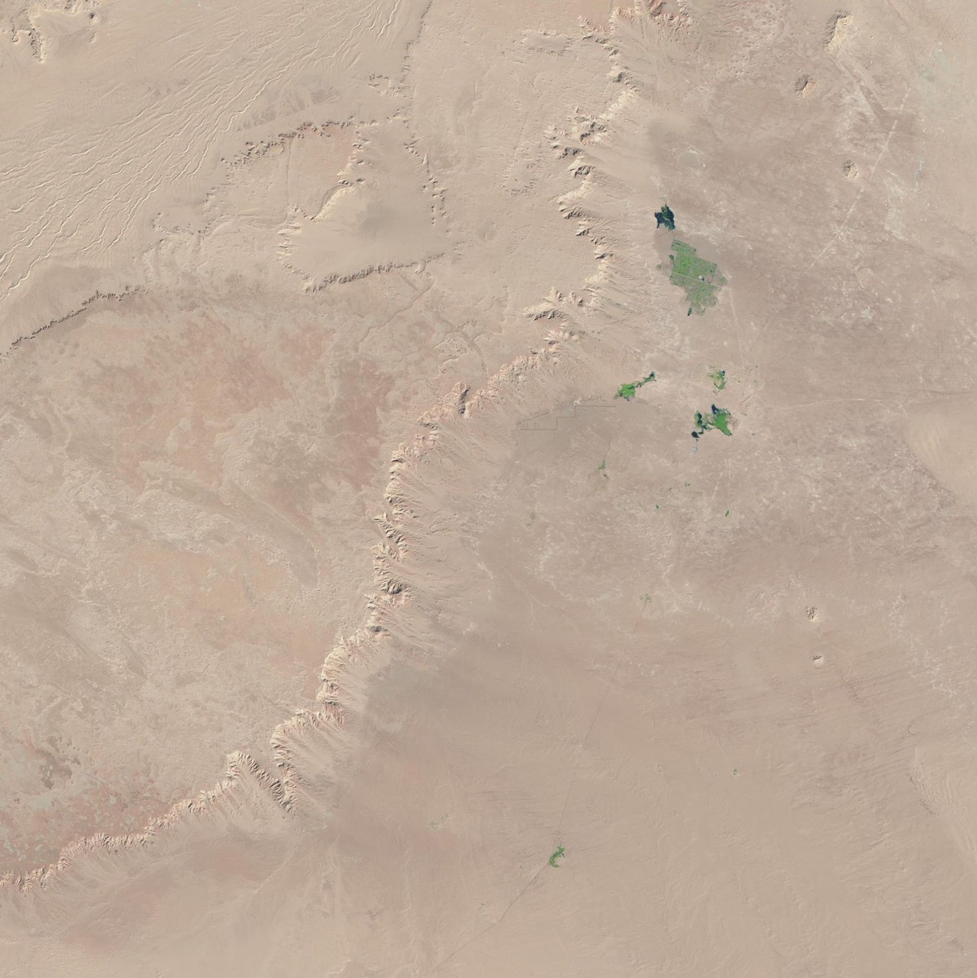
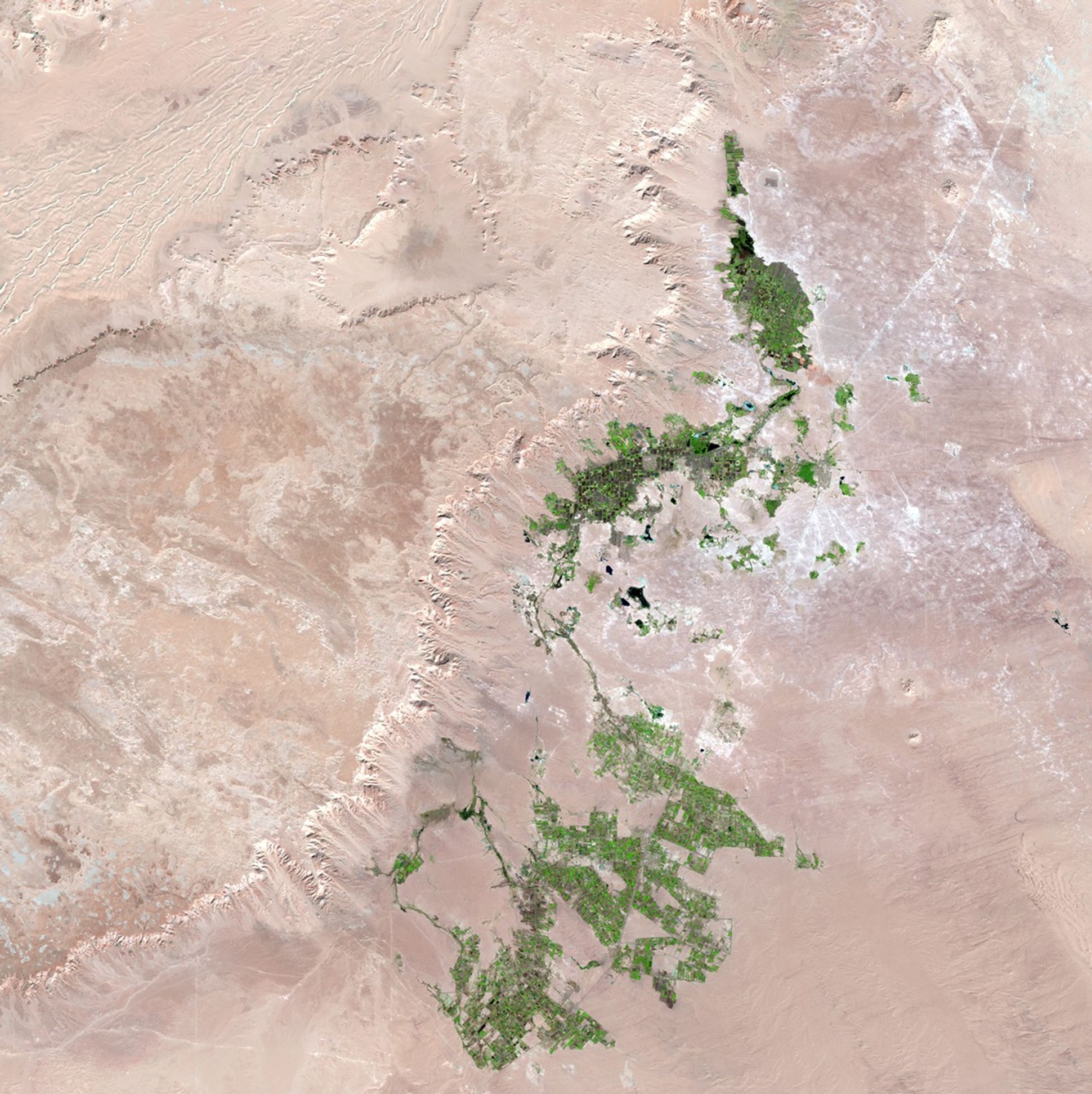
Agricultural growth near Qasr al Farafra, Egypt
January 30, 1987 - October 25, 2012
Unlike much newly developed desert agriculture, the western Egyptian fields seen here are watered not by deep-well irrigation, but rather with surface water associated with the Al Farafra Oasis. These images show the increased agricultural activity near the town of Qasr al Farafra. Increased accessibility from improved infrastructure, including paved roads to the town, brings both agricultural laborers and tourists. Images taken by the Thematic Mapper sensor onboard Landsat 5 and the Enhanced Thematic Mapper Plus onboard Landsat 7. Source: U.S. Geological Survey (USGS) Landsat Missions Gallery, "Al Farafra Oasis," U.S. Department of the Interior / USGS and NASA.