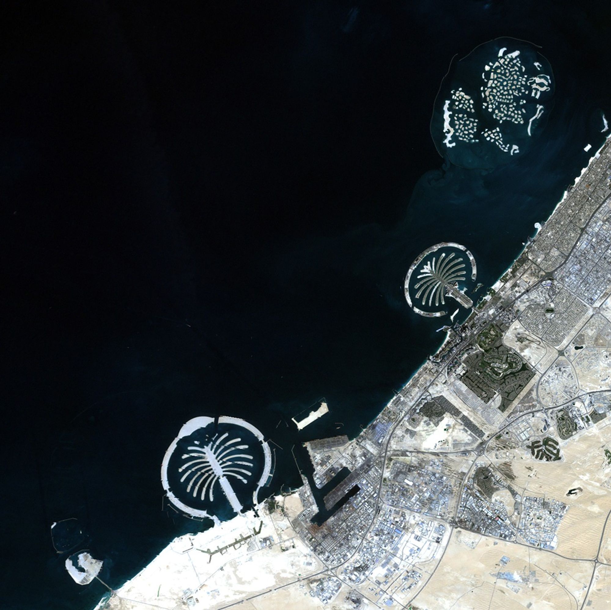
Due to the lapse in federal government funding, NASA is not updating this website.

Suggested Searches

1 min read

Artificial islands, United Arab Emirates

before
after
The city of Dubai is situated along the Persian Gulf in the United Arab Emirates. In 2001, work began to create artificial archipelagos along Dubai's shoreline. The results are visible in the 2012 image: Palm Jebel Ali, the smaller Palm Jumeirah and, north of the two "palm islands," a group of smaller islands known as "The World" because they are roughly in the shape of a world map. The World provides an additional 144 miles of shoreline.   Images taken by the Enhanced Thematic Mapper Plus sensor onboard Landsat 7. Source: U.S. Geological Survey (USGS) Landsat Missions Gallery “Dubai’s Islands,” U.S. Department of the Interior / USGS and NASA.
The city of Dubai is situated along the Persian Gulf in the United Arab Emirates. In 2001, work began to create artificial archipelagos along Dubai's shoreline. The results are visible in the 2012 image: Palm Jebel Ali, the smaller Palm Jumeirah and, north of the two "palm islands," a group of smaller islands known as "The World" because they are roughly in the shape of a world map. The World provides an additional 144 miles of shoreline. Images taken by the Enhanced Thematic Mapper Plus sensor onboard Landsat 7. Source: U.S. Geological Survey (USGS) Landsat Missions Gallery “Dubai’s Islands,” U.S. Department of the Interior / USGS and NASA.

Before and After

Artificial islands, United Arab Emirates

November 27, 2001 - November 12, 2012

The city of Dubai is situated along the Persian Gulf in the United Arab Emirates. In 2001, work began to create artificial archipelagos along Dubai's shoreline. The results are visible in the 2012 image: Palm Jebel Ali, the smaller Palm Jumeirah and, north of the two "palm islands," a group of smaller islands known as "The World" because they are roughly in the shape of a world map. The World provides an additional 144 miles of shoreline. Images taken by the Enhanced Thematic Mapper Plus sensor onboard Landsat 7. Source: U.S. Geological Survey (USGS) Landsat Missions Gallery “Dubai’s Islands,” U.S. Department of the Interior / USGS and NASA.

Downloads

Image 1

JPEG

(2 MB)

Image 2

JPEG

(2 MB)