


before
after
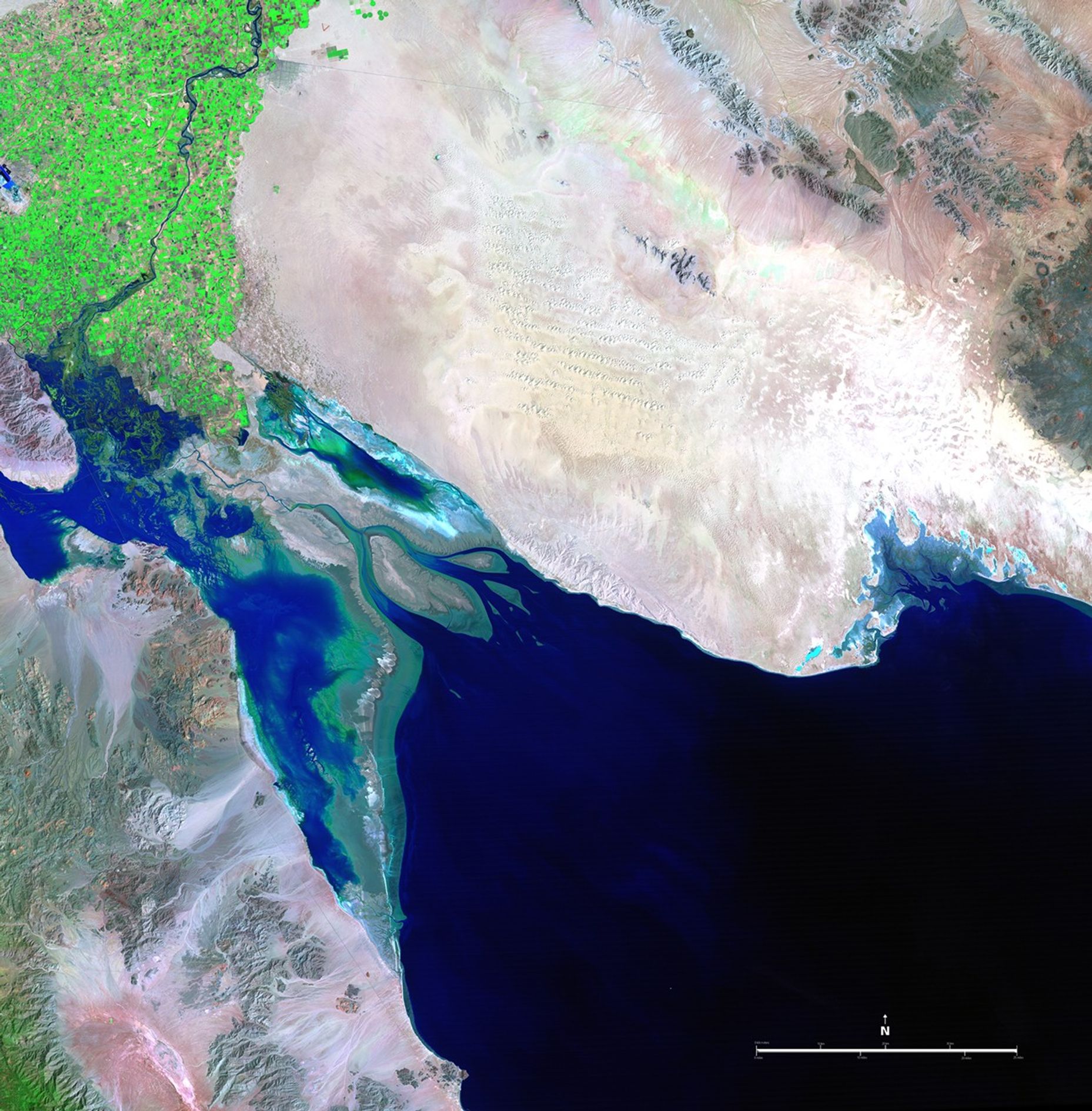
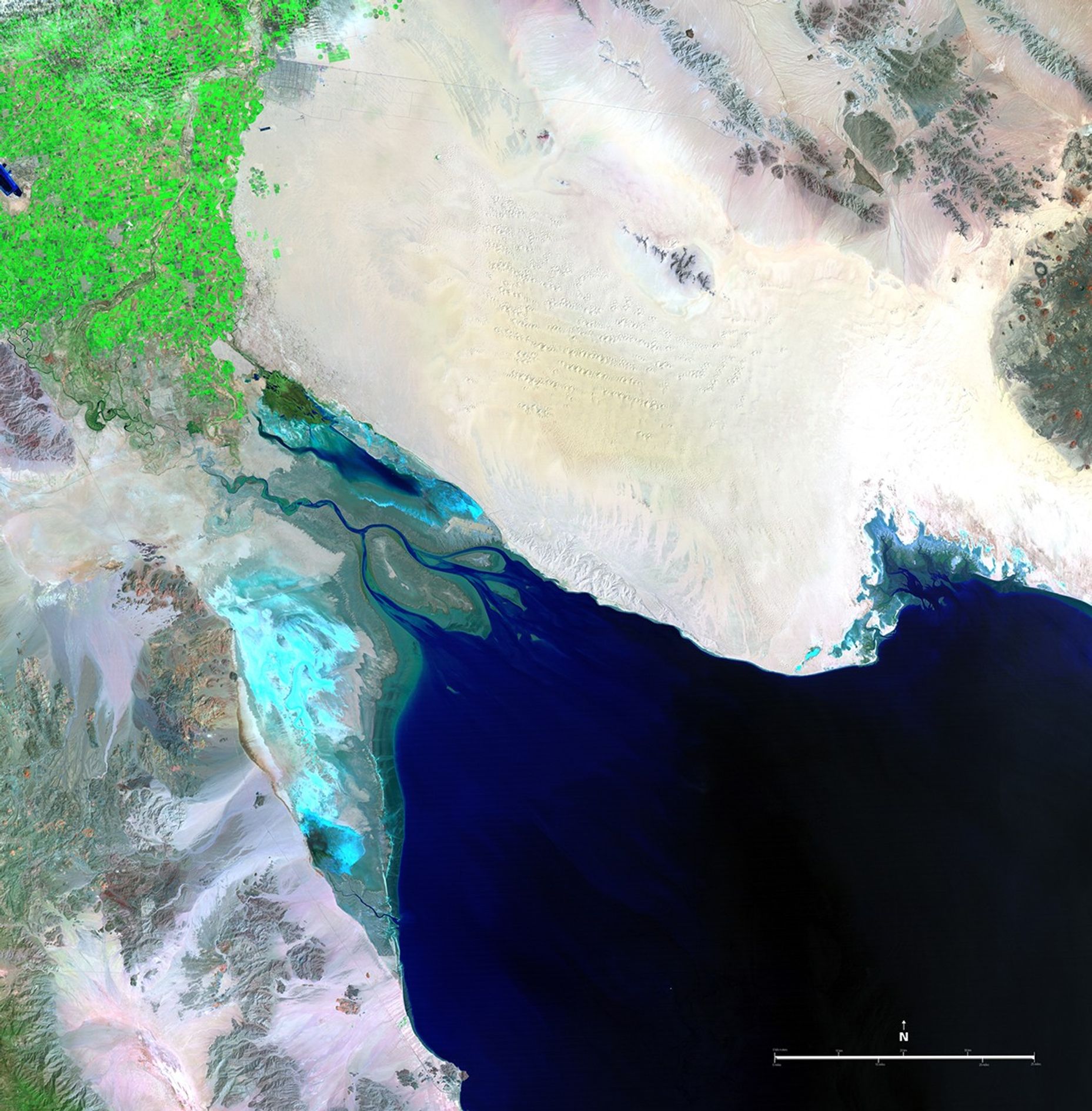
These two pictures illustrate the extremes of water flow in the Colorado River since measurements began in the late 1800s. The 1985 image was taken in the midst of record high flow, while the 2007 image shows the driest period. Excessive rains or severe droughts directly change the amount of water available in the Colorado River Basin, and so does the increasing pressure of human needs throughout the western states. The river, which has its headwaters in the snowmelt of the Rocky Mountains, is 1,400 miles (2,253 kilometers) long and empties into the Gulf of California, also known as the Sea of Cortez. It provides water for drinking, irrigation, electricity, industry, and recreation for seven U.S. and two Mexican states, serving more than 25 million people. Images taken by the Thematic Mapper sensor onboard Landsat 5. Source: U.S. Geological Survey (USGS) Landsat Missions Gallery, "Colorado River into the Gulf of California," U.S. Department of the Interior / USGS and NASA.
These two pictures illustrate the extremes of water flow in the Colorado River since measurements began in the late 1800s. The 1985 image was taken in the midst of record high flow, while the 2007 image shows the driest period. Excessive rains or severe droughts directly change the amount of water available in the Colorado River Basin, and so does the increasing pressure of human needs throughout the western states. The river, which has its headwaters in the snowmelt of the Rocky Mountains, is 1,400 miles (2,253 kilometers) long and empties into the Gulf of California, also known as the Sea of Cortez. It provides water for drinking, irrigation, electricity, industry, and recreation for seven U.S. and two Mexican states, serving more than 25 million people. Images taken by the Thematic Mapper sensor onboard Landsat 5. Source: U.S. Geological Survey (USGS) Landsat Missions Gallery, "Colorado River into the Gulf of California," U.S. Department of the Interior / USGS and NASA.
These two pictures illustrate the extremes of water flow in the Colorado River since measurements began in the late 1800s. The 1985 image was taken in the midst of record high flow, while the 2007 image shows the driest period. Excessive rains or severe droughts directly change the amount of water available in the Colorado River Basin, and so does the increasing pressure of human needs throughout the western states. The river, which has its headwaters in the snowmelt of the Rocky Mountains, is 1,400 miles (2,253 kilometers) long and empties into the Gulf of California, also known as the Sea of Cortez. It provides water for drinking, irrigation, electricity, industry, and recreation for seven U.S. and two Mexican states, serving more than 25 million people. Images taken by the Thematic Mapper sensor onboard Landsat 5. Source: U.S. Geological Survey (USGS) Landsat Missions Gallery, "Colorado River into the Gulf of California," U.S. Department of the Interior / USGS and NASA.
These two pictures illustrate the extremes of water flow in the Colorado River since measurements began in the late 1800s. The 1985 image was taken in the midst of record high flow, while the 2007 image shows the driest period. Excessive rains or severe droughts directly change the amount of water available in the Colorado River Basin, and so does the increasing pressure of human needs throughout the western states. The river, which has its headwaters in the snowmelt of the Rocky Mountains, is 1,400 miles (2,253 kilometers) long and empties into the Gulf of California, also known as the Sea of Cortez. It provides water for drinking, irrigation, electricity, industry, and recreation for seven U.S. and two Mexican states, serving more than 25 million people. Images taken by the Thematic Mapper sensor onboard Landsat 5. Source: U.S. Geological Survey (USGS) Landsat Missions Gallery, "Colorado River into the Gulf of California," U.S. Department of the Interior / USGS and NASA.
before
after
Before and After
Colorado River evolution, Mexico
March 24, 1985 - April 6, 2007
These two pictures illustrate the extremes of water flow in the Colorado River since measurements began in the late 1800s. The 1985 image was taken in the midst of record high flow, while the 2007 image shows the driest period. Excessive rains or severe droughts directly change the amount of water available in the Colorado River Basin, and so does the increasing pressure of human needs throughout the western states. The river, which has its headwaters in the snowmelt of the Rocky Mountains, is 1,400 miles (2,253 kilometers) long and empties into the Gulf of California, also known as the Sea of Cortez. It provides water for drinking, irrigation, electricity, industry, and recreation for seven U.S. and two Mexican states, serving more than 25 million people. Images taken by the Thematic Mapper sensor onboard Landsat 5. Source: U.S. Geological Survey (USGS) Landsat Missions Gallery, "Colorado River into the Gulf of California," U.S. Department of the Interior / USGS and NASA.


