By Earth Resources Observation and Science (EROS) Center
Sometimes it takes distance to really see something. Take the Earth observing Landsat satellites. They’re orbiting 438 miles above us, but they capture data about what’s on the ground surrounding us—and in remote places that very few have walked.
The Landsat satellite program, with its unparalleled 53-year historic record, can even reveal what has changed about the land since your parents or grandparents were your age. Maybe the forest in their favorite camping area was devastated by a wildfire or insect outbreak, or their childhood neighborhood on the edge of town now lies nearer to the middle.
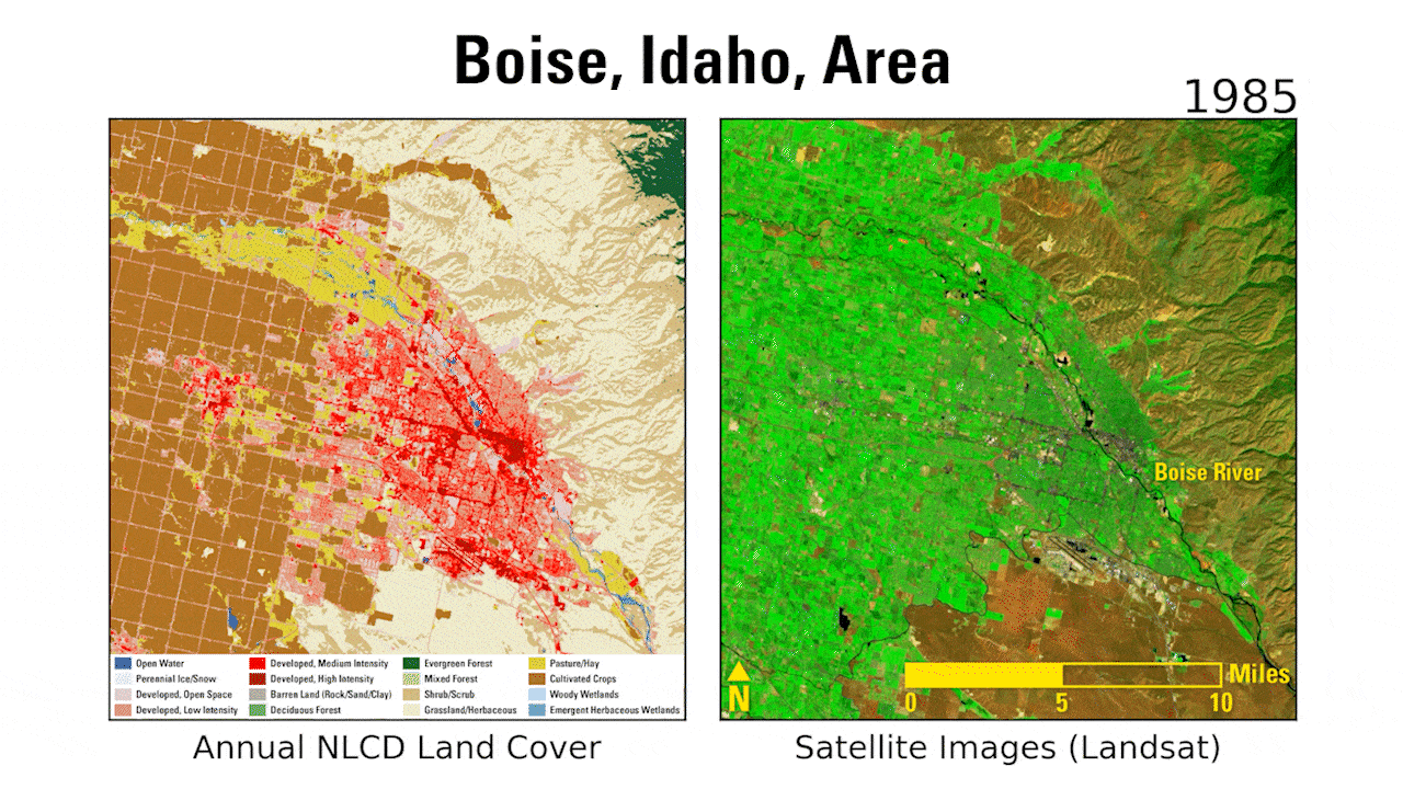
Landsat sees these changes, and so do scientists at the U.S. Geological Survey (USGS) Earth Resources Observation and Science (EROS) Center who detail different types of land cover across the United States for the Landsat-based resource Annual National Land Cover Database (NLCD). Annual NLCD data currently provides four decades of land cover and land change information across the lower 48 states from 1985 to 2024.
Annual NLCD and its predecessor, NLCD, which released data less frequently and for a shorter time series, support thousands of remotely sensed data uses in the private, public and academic sectors. The data are used to develop land management policies and assess ecosystem status. It also serves as a critical data layer in regional and national assessments of surface water and groundwater quality, wildfire monitoring and modeling, conservation efforts, disaster modeling and more.
“The number of applications for NLCD are just staggering,” said Terry Sohl, who oversees the production of Annual NLCD as the Integrated Science and Applications Branch chief at USGS EROS.

Always Evolving, Always in Use
Landsat, the pioneering civilian Earth observation satellite, remains relevant as technology within the satellites has evolved, and methods for processing and offering the data have become increasingly sophisticated. Convenient access to the public, at no cost since 2008, has also heightened Landsat’s usage.
Landsat’s annual value was calculated to be $25.6 billion in 2023, and NLCD’s share of that value is notable.
“I can’t think of any Landsat-based product that has a higher impact than NLCD,” Sohl said.
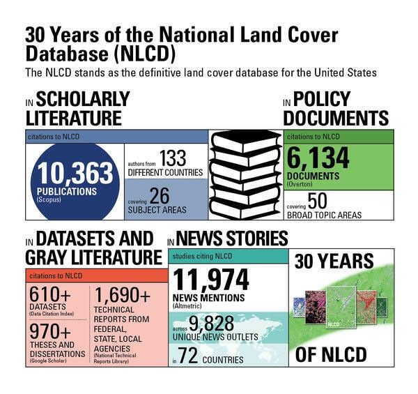
The use of NLCD data has been widespread since its beginnings as the first national scale, Landsat-based land cover product in the 1990s. It has been cited in more than 10,000 scholarly publications and more than 6,000 policy documents. In addition, there have been about 12,000 news media mentions about studies citing NLCD data.
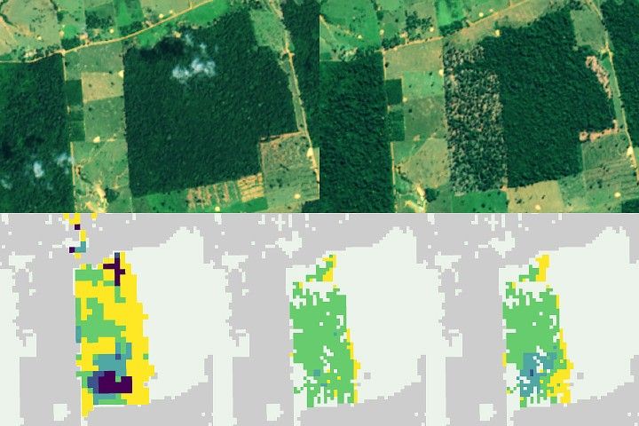
While NLCD has always been based on Landsat satellite data, its transformation into Annual NLCD in October 2024 yielded a much more robust use of the satellite program’s archive while maintaining the resource’s high-quality standards. Expanding the historical record of NLCD back to 1985 with yearly data required deep-learning processing of every single clear Landsat pixel over the United States, which each measure 30 meters by 30 meters on the ground. That’s 295 trillion pixels!
Sohl points to one factor that distinguishes both NLCD and the Landsat program from anything similar: their enduring, uninterrupted production of data.
“Landsat is the old man on the block. It’s the one that has been around forever,” Sohl said. “It’s easy to go and look at the bright, shiny new toy out there, but the thing that makes Landsat so important is the continuity. And I think that’s the same with NLCD. The nice thing about what we’ve done at EROS with NLCD is we’ve continued that continuity—and not only continued it but improved the product.”
Yearly data additions to Annual NLCD alongside future Landsat satellite launches would maintain that continuity for land managers and ultimately all residents of the United States well into the future.
And then when they are your age, your children and grandchildren will be able to spot the changes time has brought to your favorite places.
Related Resources
- National Land Cover Database
- Remote Sensing Symbiosis: How Government and Commercial Sectors Work Together
- NASA’s Brad Doorn Brings Farm Belt Wisdom to Space-Age Agriculture