


before
after
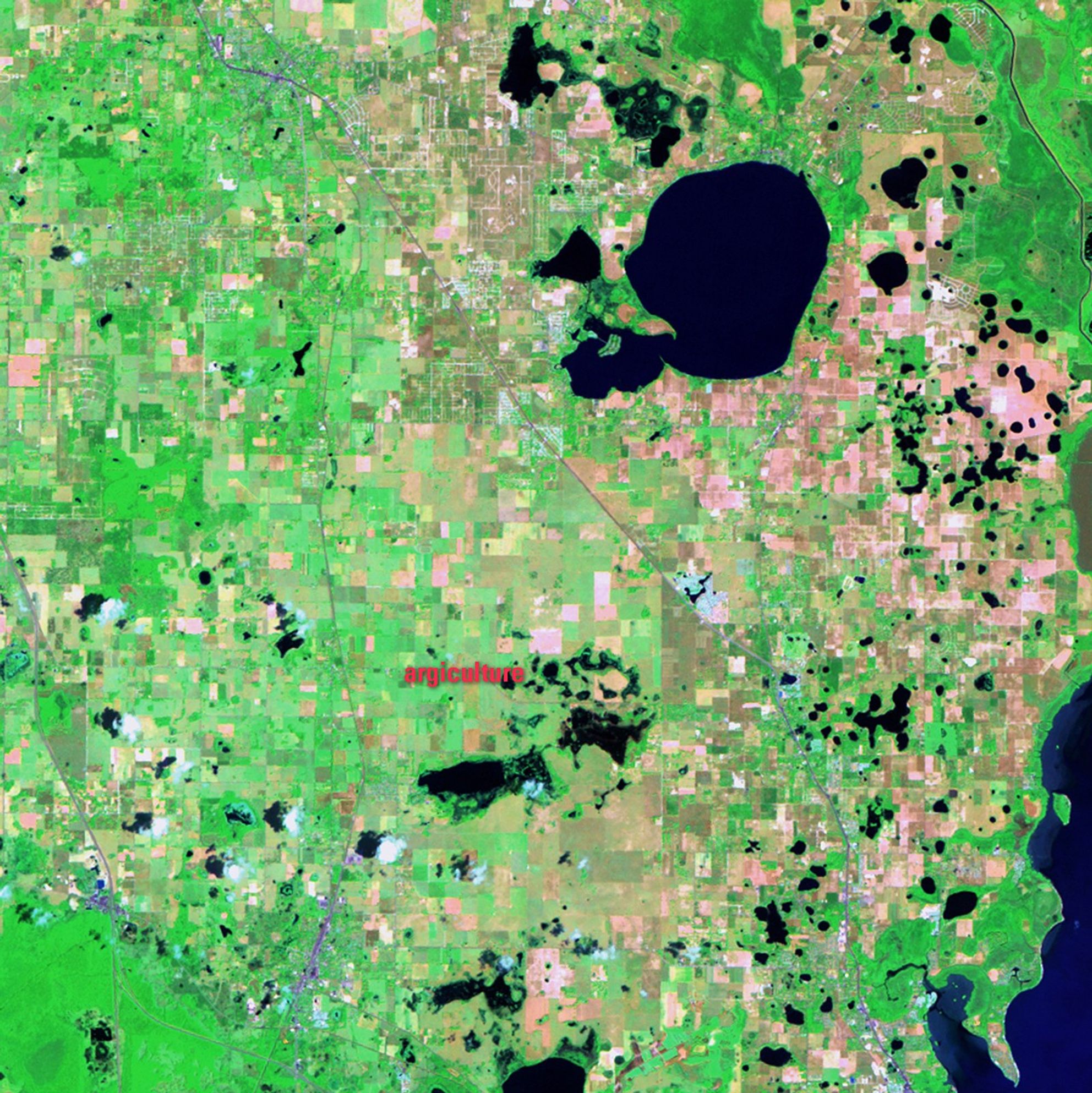
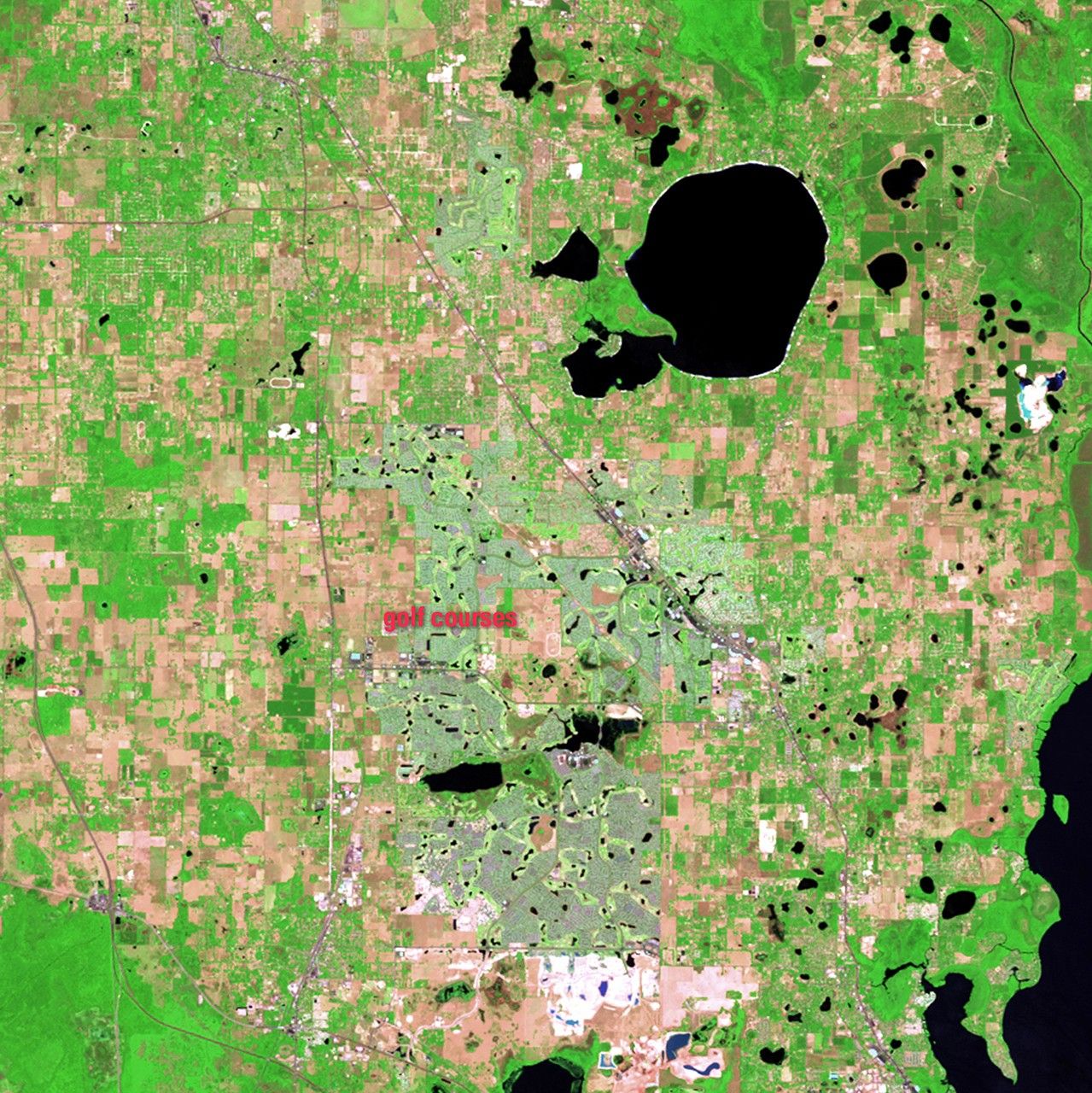
As the U.S. population has aged, more older people have been moving from northern states to southern communities. Sumpter County in central Florida grew 75 percent since 2000, largely due to expansion of The Villages, a master-planned retirement community with a strong emphasis on golf. Started as a mobile home park in the early 1980s, The Villages was the fastest growing micro-population area in the United States by 2008. These images illustrate the changes that have accompanied this growth. Agricultural land has turned into more than 40 golf courses, and small bodies of water (shown as black) have been converted to water hazards. Lakes have been drained to provide irrigation and residential communities (very light tones) have popped up around the golf courses. Images taken by the Thematic Mapper sensor onboard Landsat 5. Source: U.S. Geological Survey (USGS) Landsat Missions Gallery, "The Villages, Florida," U.S. Department of the Interior / USGS and NA
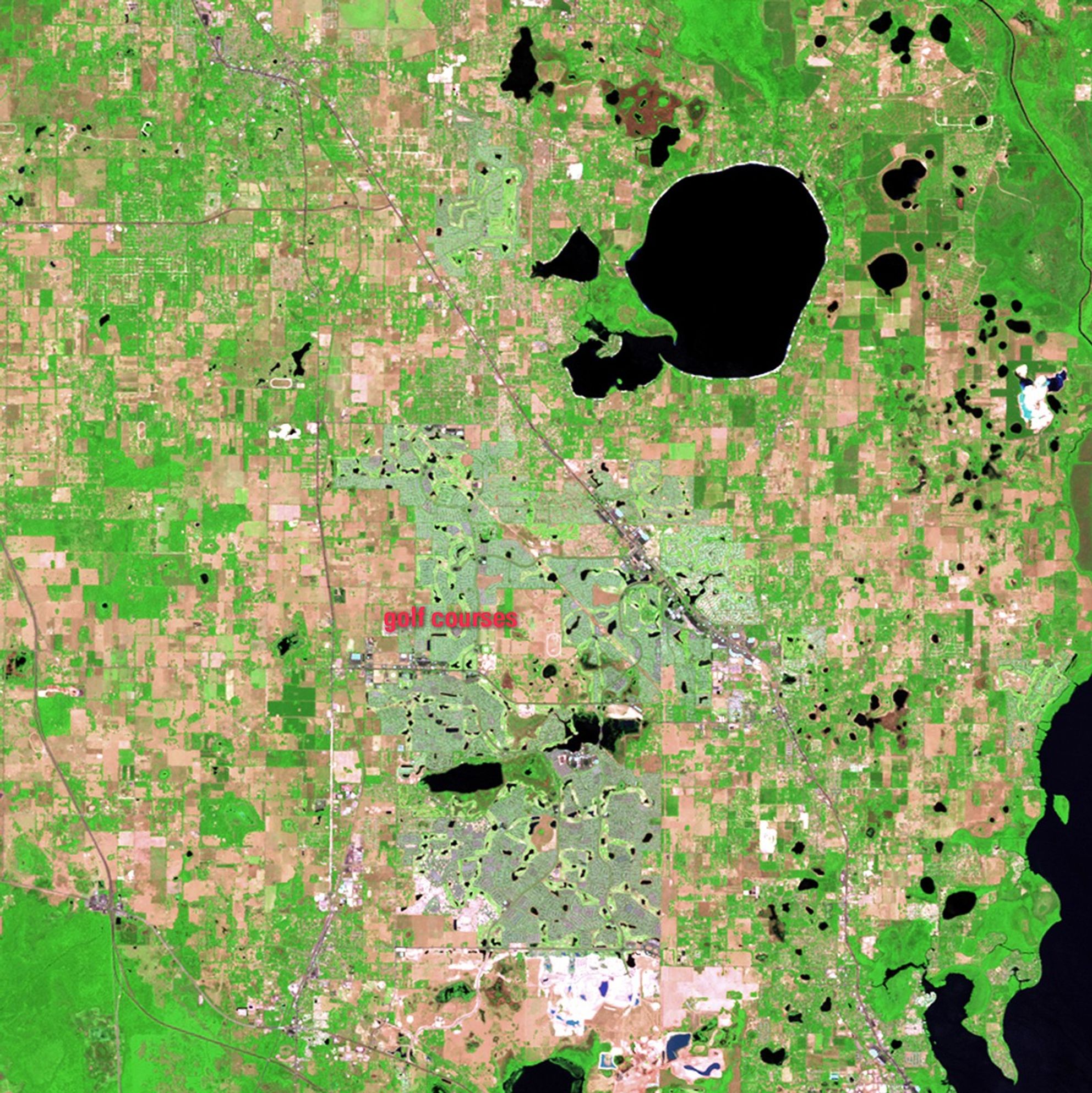
As the U.S. population has aged, more older people have been moving from northern states to southern communities. Sumpter County in central Florida grew 75 percent since 2000, largely due to expansion of The Villages, a master-planned retirement community with a strong emphasis on golf. Started as a mobile home park in the early 1980s, The Villages was the fastest growing micro-population area in the United States by 2008. These images illustrate the changes that have accompanied this growth. Agricultural land has turned into more than 40 golf courses, and small bodies of water (shown as black) have been converted to water hazards. Lakes have been drained to provide irrigation and residential communities (very light tones) have popped up around the golf courses. Images taken by the Thematic Mapper sensor onboard Landsat 5. Source: U.S. Geological Survey (USGS) Landsat Missions Gallery, "The Villages, Florida," U.S. Department of the Interior / USGS and NA
As the U.S. population has aged, more older people have been moving from northern states to southern communities. Sumpter County in central Florida grew 75 percent since 2000, largely due to expansion of The Villages, a master-planned retirement community with a strong emphasis on golf. Started as a mobile home park in the early 1980s, The Villages was the fastest growing micro-population area in the United States by 2008. These images illustrate the changes that have accompanied this growth. Agricultural land has turned into more than 40 golf courses, and small bodies of water (shown as black) have been converted to water hazards. Lakes have been drained to provide irrigation and residential communities (very light tones) have popped up around the golf courses. Images taken by the Thematic Mapper sensor onboard Landsat 5. Source: U.S. Geological Survey (USGS) Landsat Missions Gallery, "The Villages, Florida," U.S. Department of the Interior / USGS and NA
As the U.S. population has aged, more older people have been moving from northern states to southern communities. Sumpter County in central Florida grew 75 percent since 2000, largely due to expansion of The Villages, a master-planned retirement community with a strong emphasis on golf. Started as a mobile home park in the early 1980s, The Villages was the fastest growing micro-population area in the United States by 2008. These images illustrate the changes that have accompanied this growth. Agricultural land has turned into more than 40 golf courses, and small bodies of water (shown as black) have been converted to water hazards. Lakes have been drained to provide irrigation and residential communities (very light tones) have popped up around the golf courses. Images taken by the Thematic Mapper sensor onboard Landsat 5. Source: U.S. Geological Survey (USGS) Landsat Missions Gallery, "The Villages, Florida," U.S. Department of the Interior / USGS and NA
before
after
Before and After
Land change in The Villages, Florida
May 14, 1984 - May 25, 2011
As the U.S. population has aged, more older people have been moving from northern states to southern communities. Sumpter County in central Florida grew 75 percent since 2000, largely due to expansion of The Villages, a master-planned retirement community with a strong emphasis on golf. Started as a mobile home park in the early 1980s, The Villages was the fastest growing micro-population area in the United States by 2008. These images illustrate the changes that have accompanied this growth. Agricultural land has turned into more than 40 golf courses, and small bodies of water (shown as black) have been converted to water hazards. Lakes have been drained to provide irrigation and residential communities (very light tones) have popped up around the golf courses. Images taken by the Thematic Mapper sensor onboard Landsat 5. Source: U.S. Geological Survey (USGS) Landsat Missions Gallery, "The Villages, Florida," U.S. Department of the Interior / USGS and NASA.


