


Images of Change
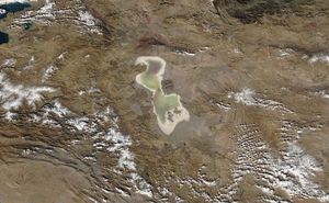
Iran's Lake Urmia is one of the world's largest hypersaline (extremely salty) lakes. It has been declared a Wetland of International Importance and a UNESCO Biosphere Reserve. But as reported by the United Nations Environment Programme, its water level began…
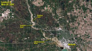
Sanford Dam failed on May 19, 2020, flooding the area downstream. The image on the right was taken the following day, when the Tittabawassee River peaked some 10 feet above flood stage at Midland, Michigan. Muddy floodwater is visible spilling…
In much of the U.S., spring began unusually early in 2020. These images compare an area near the border of North and South Carolina in early March of 2018 and 2020. In the latter year, the area saw its earliest…
The 2019 image shows Mt. Shishaldin (left), a volcano on the eastern edge of Alaska's Aleutian Island chain, after a series of low-level eruptions that occurred the previous month. The 2020 image catches Shishaldin during a larger eruption that shot a…

These images contrast the sunlight Antarctica receives near spring equinox (September image) and summer solstice (December image). The low sun angles near equinox create longer shadows that reveal the ruggedness of the mountains. The higher angles near solstice shorten the…
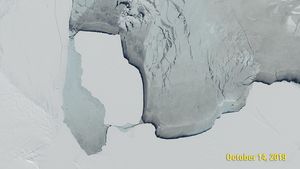
These images show D28, an iceberg estimated to weigh 315 billion tons (286 billion metric tons), before and after it broke free from Antarctica's Amery Ice Shelf and drifted into the Southern Ocean.
The 2011 image shows the remains of the Japanese town of Rikuzentakata (gray area in center) less than a month after a devastating tsunami.
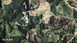
These images compare a Christmas tree farm in Ashe County, North Carolina, before and after a substantial number of trees were harvested.
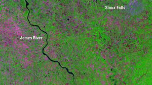
Abnormally high spring rainfall and subsequent flooding in 2019 had a season-long impact on farming in the Midwest. By August 22, the U.S. Department of Agriculture reported 3.9 million "prevented planting" acres — fields too flooded to plant — in South Dakota,…
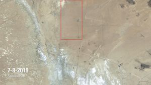
The July image shows a rupture in the Mojave Desert, caused by a magnitude 7.1 earthquake on July 5, 2019, the day after a magnitude 6.4 quake struck the same region.
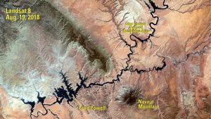
The 1984 image shows Lake Powell a year after its highest water level was recorded. The 2018 image was taken following a period of drought that began in 2000.
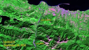
The 2011 image shows the Elwha River, in northwestern Washington state, when it still hosted two dams that were built in the early 1900s: the Glines Canyon Dam, which created the Lake Mills reservoir, and the Elwha Dam, which created…
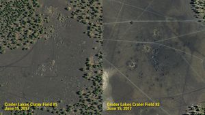
The U.S. Geological Survey created the two Cinder Lake crater fields, near Flagstaff, Arizona, to help train Apollo astronauts bound for the lunar surface.
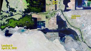
UNESCO declared southern Iraq’s marshes (“al-Ahwar” in Arabic) a World Heritage Site in 2016, citing their biodiversity and contribution to ancient Mesopotamian societies.
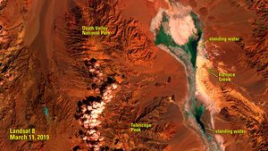
Death Valley is one of the driest places in North America. A typical March sees about a third of an inch (about 8 millimeters) of rain.
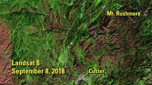
These false-color images contrast a section of pine forest in the Black Hills of South Dakota before and after an epidemic of mountain pine beetles.
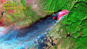
The Camp Fire burned more than 153,000 acres of Butte County, California, in November 2018. The California Department of Forestry and Fire Protection (CAL FIRE) reported that it was California’s deadliest and most destructive wildfire, responsible for 85 deaths and the…
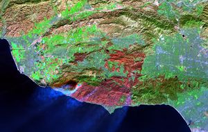
The Woolsey Fire burned some 97,000 acres of Southern California in November 2018. The large maroon patch at the bottom of the later image shows, in false color, the burn scar between Los Angeles, Thousand Oaks and Malibu.
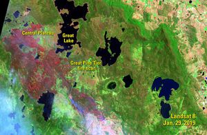
The earlier image shows the Central Plateau of the Australian state of Tasmania, three days before the Tasmania Fire Service announced that lightning strikes had ignited dozens of fires across the island state.
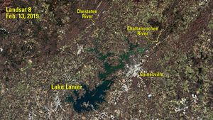
Lake Lanier is a reservoir in northern Georgia, covering 59 square miles (about 153 square kilometers), that is fed by the Chattahoochee and Chestatee rivers.
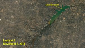
Lake Meredith is a reservoir on the Canadian River in the Texas Panhandle. More than a decade of drought brought its depth to a record low in 2013.
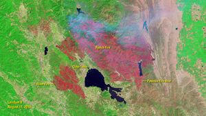
The 2018 Ranch and River fires in Northern California are known jointly as the Mendocino Complex fire, the largest wildfire since reliable record-keeping in California began in 1932.
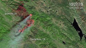
These images show a portion of Northern California before and during the Kincade Fire, which burned nearly 78,000 acres (about 31,500 hectares) from Oct. 23 to Nov. 6, 2019. Evacuation zones included the entire towns of Geyserville, Healdsburg and Windsor,…
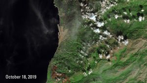
The Oct. 8 image shows a portion of Lebanon before the wildfires of mid-October 2019. The burn scars they left are visible as brown patches at the bottom of the Oct. 18 image. North of the scars is Beirut, the…
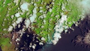
New fissures opened up in the Pu’u ‘O’o Crater of the Kilauea volcano on the island of Hawaii in May 2018, spouting lava that destroyed homes in the Leilani Estates neighborhood.


