The Salmon River Reservoir in New York State was created in 1914, when a hydroelectric power dam was built. Water levels fluctuate with spring showers and winter snowmelt, but the reservoir has steadily grown since the Landsat satellite began monitoring it in 1985. Record rainfall in September 2010 was a major cause of the reservoir's expansion seen in the 2011 picture. When lowlands flooded after the rain, the reservoir proved critical in holding back waters that would have caused extensive damage to shoreline property downstream. Land managers and other officials use Landsat images to help them make decisions about additional growth or diversion of water in this area. Images taken by the Thematic Mapper sensor onboard Landsat 5. Source: U.S. Geological Survey (USGS) Landsat Missions Gallery, "Salmon River Reservoir, New York 1985-2011," U.S. Department of the Interior / USGS and N
The Salmon River Reservoir in New York State was created in 1914, when a hydroelectric power dam was built. Water levels fluctuate with spring showers and winter snowmelt, but the reservoir has steadily grown since the Landsat satellite began monitoring it in 1985. Record rainfall in September 2010 was a major cause of the reservoir's expansion seen in the 2011 picture. When lowlands flooded after the rain, the reservoir proved critical in holding back waters that would have caused extensive damage to shoreline property downstream. Land managers and other officials use Landsat images to help them make decisions about additional growth or diversion of water in this area. Images taken by the Thematic Mapper sensor onboard Landsat 5. Source: U.S. Geological Survey (USGS) Landsat Missions Gallery, "Salmon River Reservoir, New York 1985-2011," U.S. Department of the Interior / USGS and N

The Salmon River Reservoir in New York State was created in 1914, when a hydroelectric power dam was built. Water levels fluctuate with spring showers and winter snowmelt, but the reservoir has steadily grown since the Landsat satellite began monitoring it in 1985. Record rainfall in September 2010 was a major cause of the reservoir's expansion seen in the 2011 picture. When lowlands flooded after the rain, the reservoir proved critical in holding back waters that would have caused extensive damage to shoreline property downstream. Land managers and other officials use Landsat images to help them make decisions about additional growth or diversion of water in this area. Images taken by the Thematic Mapper sensor onboard Landsat 5. Source: U.S. Geological Survey (USGS) Landsat Missions Gallery, "Salmon River Reservoir, New York 1985-2011," U.S. Department of the Interior / USGS and N

The Salmon River Reservoir in New York State was created in 1914, when a hydroelectric power dam was built. Water levels fluctuate with spring showers and winter snowmelt, but the reservoir has steadily grown since the Landsat satellite began monitoring it in 1985. Record rainfall in September 2010 was a major cause of the reservoir's expansion seen in the 2011 picture. When lowlands flooded after the rain, the reservoir proved critical in holding back waters that would have caused extensive damage to shoreline property downstream. Land managers and other officials use Landsat images to help them make decisions about additional growth or diversion of water in this area. Images taken by the Thematic Mapper sensor onboard Landsat 5. Source: U.S. Geological Survey (USGS) Landsat Missions Gallery, "Salmon River Reservoir, New York 1985-2011," U.S. Department of the Interior / USGS and N
before
after
Before and After
Salmon River Reservoir growth, New York
July 29, 1985 - July 5, 2011
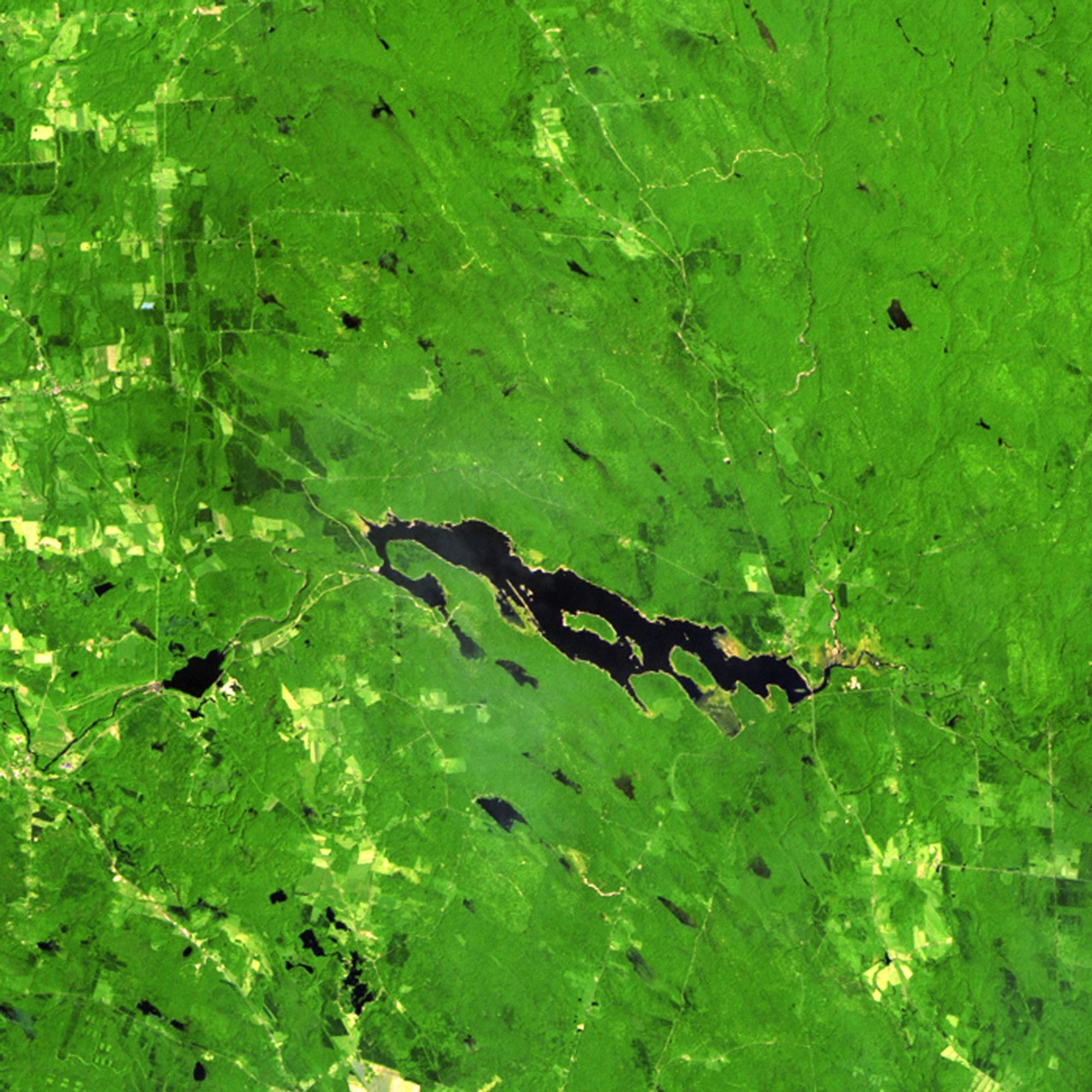
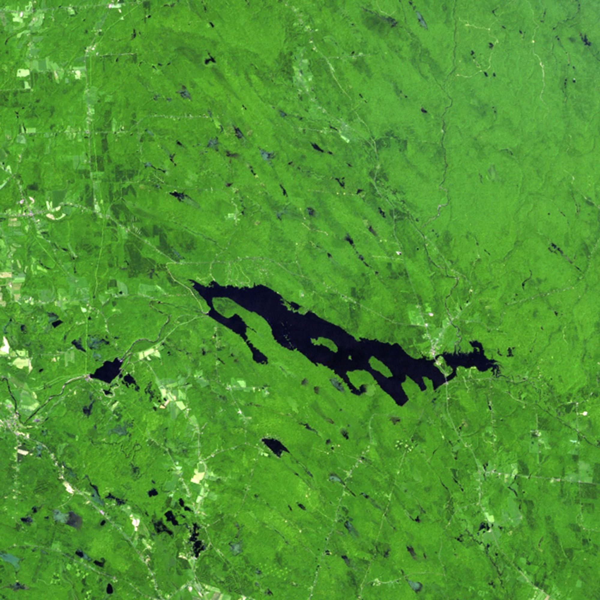
The Salmon River Reservoir in New York State was created in 1914, when a hydroelectric power dam was built. Water levels fluctuate with spring showers and winter snowmelt, but the reservoir has steadily grown since the Landsat satellite began monitoring it in 1985. Record rainfall in September 2010 was a major cause of the reservoir's expansion seen in the 2011 picture. When lowlands flooded after the rain, the reservoir proved critical in holding back waters that would have caused extensive damage to shoreline property downstream. Land managers and other officials use Landsat images to help them make decisions about additional growth or diversion of water in this area. Images taken by the Thematic Mapper sensor onboard Landsat 5. Source: U.S. Geological Survey (USGS) Landsat Missions Gallery, "Salmon River Reservoir, New York 1985-2011," U.S. Department of the Interior / USGS and NASA.

