


Earth Stories
Filters

A massive, old caldera and more recently formed craters shape the landscape in the eastern Sierra Nevada.

The state was unusually dry for much of 2025, but the intensity of the drought has ratcheted up since January 2026.

Scientists pioneered a new system that combines data from multiple Earth-observing satellites to identify forest clearing up to 100 days earlier than current methods.

Patches of open water in the region contributed to low sea ice extent across the Arctic in March 2026, which tied with the lowest maximum observed in the satellite record.

The February 2026 eruption at Piton de la Fournaise has lasted longer and produced a larger volume of lava than recent eruptions from this frequently active volcano.

Strong winds in March 2026 carried Saharan dust across northwestern Africa and toward the Canary Islands, reducing visibility and prompting alerts.
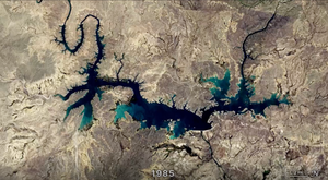
In two recent studies, researchers used Landsat data to fill key gaps in our knowledge of reservoir structure and dynamics.

Dry, warm, and windy conditions across the U.S. Great Plains led to extreme fire activity in March 2026.

A network of meltwater lakes and drainage channels made an Antarctic ice shelf known for its blue ice areas even bluer.

The activity of herring around Vancouver Island in British Columbia brightened coastal waters enough to be detectable from space.