


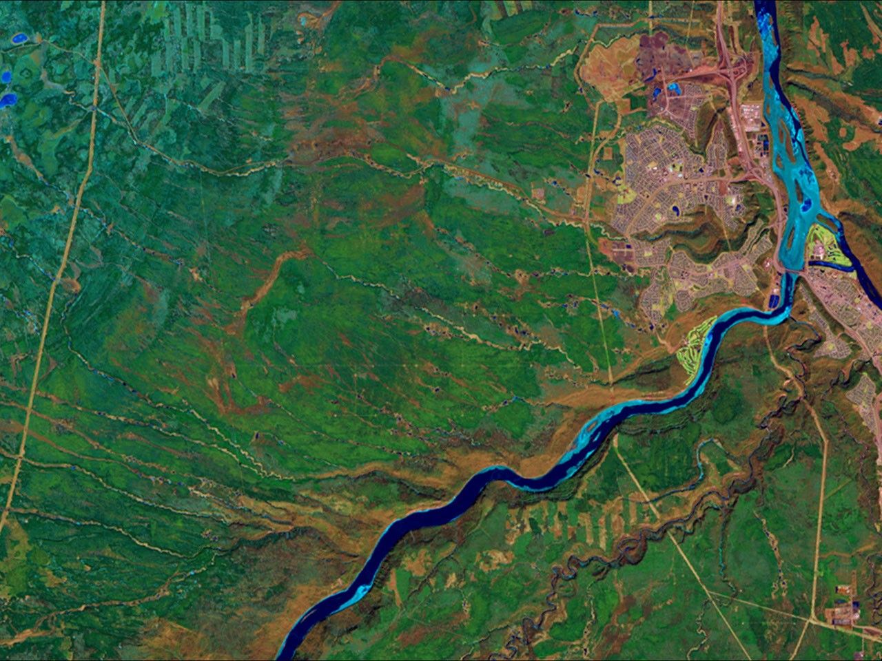
before
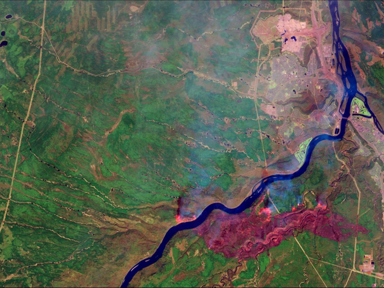
after

A massive wildfire near Fort McMurray in Alberta, Canada, destroyed at least 1,600 structures and forced the largest evacuation on record in Canada, involving more than 88,000 people. By May 5, fire had consumed almost 210,000 acres. The false-color images in the May picture depict active hot spots as bright orange, the burned area as dark red and smoke as hazy blue. This location is home to the Athabasca oil sands, the largest known reservoir of crude bitumen in the world. Images taken by the Operational Land Imager onboard Landsat 8. Source: U.S. Geological Survey (USGS) Landsat Missions Gallery; Wildfire Forces Evacuations in Fort McMurray, Alberta; U.S. Department of the Interior / USGS and NASA.

A massive wildfire near Fort McMurray in Alberta, Canada, destroyed at least 1,600 structures and forced the largest evacuation on record in Canada, involving more than 88,000 people. By May 5, fire had consumed almost 210,000 acres. The false-color images in the May picture depict active hot spots as bright orange, the burned area as dark red and smoke as hazy blue. This location is home to the Athabasca oil sands, the largest known reservoir of crude bitumen in the world. Images taken by the Operational Land Imager onboard Landsat 8. Source: U.S. Geological Survey (USGS) Landsat Missions Gallery; Wildfire Forces Evacuations in Fort McMurray, Alberta; U.S. Department of the Interior / USGS and NASA.
A massive wildfire near Fort McMurray in Alberta, Canada, destroyed at least 1,600 structures and forced the largest evacuation on record in Canada, involving more than 88,000 people. By May 5, fire had consumed almost 210,000 acres. The false-color images in the May picture depict active hot spots as bright orange, the burned area as dark red and smoke as hazy blue. This location is home to the Athabasca oil sands, the largest known reservoir of crude bitumen in the world. Images taken by the Operational Land Imager onboard Landsat 8. Source: U.S. Geological Survey (USGS) Landsat Missions Gallery; Wildfire Forces Evacuations in Fort McMurray, Alberta; U.S. Department of the Interior / USGS and NASA.
A massive wildfire near Fort McMurray in Alberta, Canada, destroyed at least 1,600 structures and forced the largest evacuation on record in Canada, involving more than 88,000 people. By May 5, fire had consumed almost 210,000 acres. The false-color images in the May picture depict active hot spots as bright orange, the burned area as dark red and smoke as hazy blue. This location is home to the Athabasca oil sands, the largest known reservoir of crude bitumen in the world. Images taken by the Operational Land Imager onboard Landsat 8. Source: U.S. Geological Survey (USGS) Landsat Missions Gallery; Wildfire Forces Evacuations in Fort McMurray, Alberta; U.S. Department of the Interior / USGS and NASA.
before
after
Before and After
Wildfires near Fort McMurray in Alberta, Canada
April 17, 2016 - May 3, 2016
A massive wildfire near Fort McMurray in Alberta, Canada, destroyed at least 1,600 structures and forced the largest evacuation on record in Canada, involving more than 88,000 people. By May 5, fire had consumed almost 210,000 acres. The false-color images in the May picture depict active hot spots as bright orange, the burned area as dark red and smoke as hazy blue. This location is home to the Athabasca oil sands, the largest known reservoir of crude bitumen in the world. Images taken by the Operational Land Imager onboard Landsat 8. Source: U.S. Geological Survey (USGS) Landsat Missions Gallery; Wildfire Forces Evacuations in Fort McMurray, Alberta; U.S. Department of the Interior / USGS and NASA.


