![Request for Information – Potential [Placeholder for Prize]](https://assets.science.nasa.gov/dynamicimage/assets/science/missions/a-step/FFR_Earth_Background_20251120%20.png?w=1024)


GLOBE Observer Trees Tool Supports the Chesapeake Bay Foundation’s Keystone 10 Million Trees Partnership
The Chesapeake Bay Foundation's Keystone 10 (K10) Million Trees Partnership is a collaborative effort in Pennsylvania by national, regional, state, and local agencies, conservation organizations, outdoors enthusiasts, businesses, and citizens committed to improving Pennsylvania's communities, economy, and ecology. K10 is currently using the Global Learning and Observations to benefit the Environment Program (GLOBE) Observer App Trees Tool to take tree height and diameter measurements as an indicator of tree health. K10 is also working with local groups to monitor tree height and diameter over time.
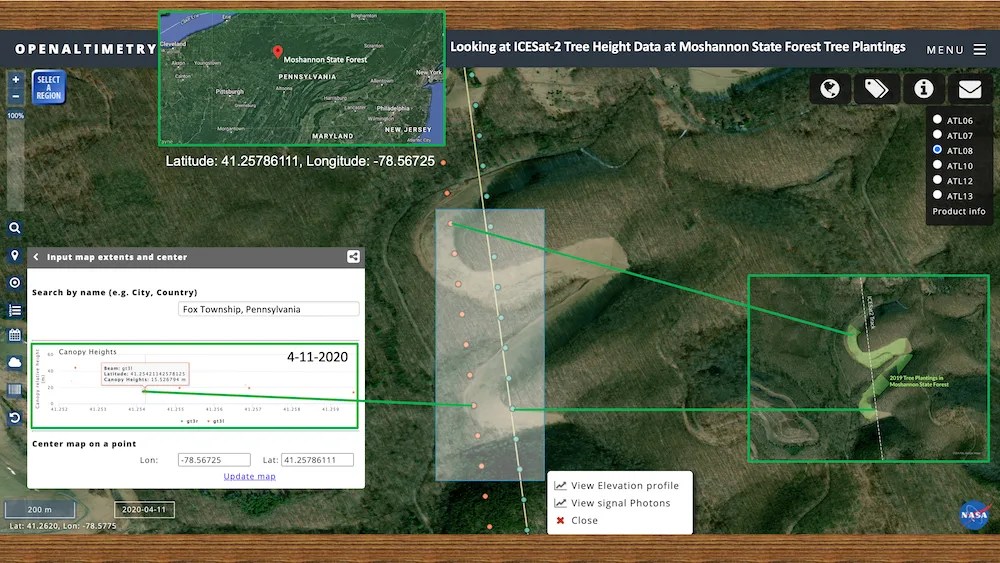
On April 29th, 2022, K10, several members of the GLOBE Observer Team (part of NASA’s Earth Science Education Collaborative), and NASA’s Ice, Cloud and land Elevation Satellite 2 (ICESat-2) mission team recently worked together to identify sites for K10 planting events and match them to measurements from instruments on NASA’s ICESat-2 satellite. Matching the ground-based GLOBE tree height observations to the ICESat-2 mission’s tree canopy height can help build a much more robust tree height dataset for student and professional researchers to potentially use in their research. Out of 46 planting sites, ICESat-2 passed over about half of them. The K10 team continues to analyze the findings of these matches and plans to update their planting sites each year to add more matches to the list.
“K10 is grateful for this partnership with NASA and the GLOBE program to connect citizens with science and spread the word about the sheer power of trees. The more trees planted, and the more measurements taken on those trees, the happier our planet—and the Bay—will be.” —Isabella DeFrancesco, Chesapeake Bay Foundation’s Making History Campaign Marketing and Communication Specialist
Learn more about how you can use the GLOBE Observer App to join in on some citizen science and fun at https://observer.globe.gov.
NASA’s Earth Science Education Collaborative is supported by NASA under cooperative agreement award number NNX16AE28A and is part of NASA's Science Activation Portfolio. Please visit https://science.nasa.gov/science-activation-team/nesec to learn more.
https://www.cbf.org/blogs/save-the-bay/2022/04/saving-the-bay-from-space.html