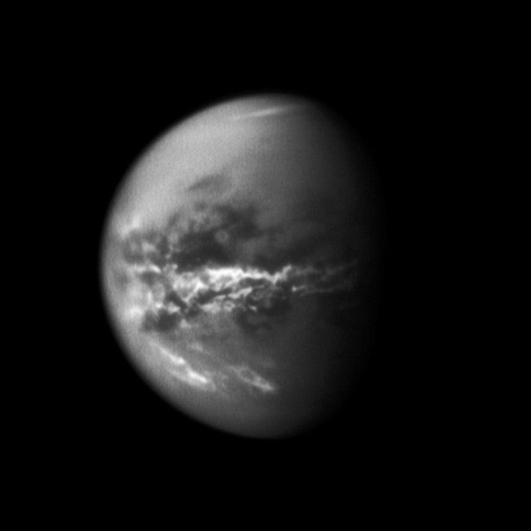
NASA's Cassini spacecraft chronicles the change of seasons as it captures clouds concentrated near the equator of Saturn's largest moon, Titan.
Editor's note: this list was written in December 2011 as a forecast of upcoming events.
Jan. 2
Titan flyby – (18,278 miles, or 29,415 kilometers) – T-80: On this high-altitude encounter, the imaging science subsystem (ISS) will perform high-resolution observations around closest-approach along the anti-Saturnian and trailing hemispheres at mid- to high southern latitudes. This is one of ISS’ so-called “10-pointer” flybys, i.e. one of the two scientifically most significant Titan flybys for ISS during the Solstice mission. As the lead instrument on the inbound approach to Titan, the composite infrared spectrometer (CIRS) instrument views Titan at various distances and spectral resolutions to make maps of atmospheric and surface temperature. After closest approach, Radar will do radiometry of the sub-Saturn hemisphere. Outbound, the the visible and infrared mapping spectrometer (VIMS) will perform stellar occultations of the stars CW Leo and R Leo, which will constrain the composition and the spectral properties of Titan’s atmosphere. During the flyby, the radio and plasma wave science (RPWS) will measure thermal plasmas in Titan's ionosphere and surrounding environment, search for lightning in Titan's atmosphere, and investigate the interaction of Titan with Saturn's magnetosphere.
Jan. 30
Titan flyby (19,343 miles, or 31,131 kilometers) – T-81: On this high-altitude encounter, ISS will perform high-resolution observations around closest-approach along Titan’s leading hemisphere at high southern latitudes, including a late view of Ontario Lacus before the Sun sets for southern winter. This is one of ISS’ so-called “10-pointer” flybys, i.e. one of the two scientifically most significant Titan flybys for ISS during the Solstice mission. ISS will also ride along with CIRS’ inbound high phase angle observations and CIRS’ outbound observations over Titan's anti-Saturnian hemisphere at low phase angles. This encounter is one of the last views of Titan’s high southern latitudes. VIMS will ride along with ISS to look for lakes in the South Pole area.
Feb. 19
Titan flyby (2,363 miles, or 3,803 kilometers) – T-82: CIRS performs a wide variety of observations, including limb sounding, and mapping of surface and atmospheric temperatures. Far-infrared limb sounding near closest approach reaches the most northerly latitude of the Solstice Mission. (75 degrees North) until 2015, providing insights into the transition of the northern polar circulation from spring to summer, and includes a search for possible condensates. VIMS rides-along to detect clouds to monitor climatic changes after the equinox.T-82 is a dusk sector equatorial flyby across Titan's magnetic tail. Similar in geometry, but at a lower altitude (2,389 miles, or 3,844 kilometers) than T-78, Cassini will be able to provide a better characterization of the magnetotail by providing samples at different radial distances from the moon at a fixed local time.
March 8-11
non-targeted flyby segment highlights:
- Long periods (over 19-hours) of ISS observations of outer irregular moons Jarnsaxa and Mundilfari to derive rotation rate and physical properties.
- Two Titan cloud monitor observations, on March 9 (2 hours) and March 10 (1:30 hour), to observe the development of cloud patterns in Titan’s atmosphere through northern spring and summer. Rainfall is also being monitored.
- Enceladus (1:45 hour) optical remote sensing (ORS) observation March 10; includes low-phase mapping.
- Rhea CIRS observation March 10 (04:35 duration); then ISS/VIMS 1:30 hour mosaic; Rhea ring search at end (01:55 hours).
March 27
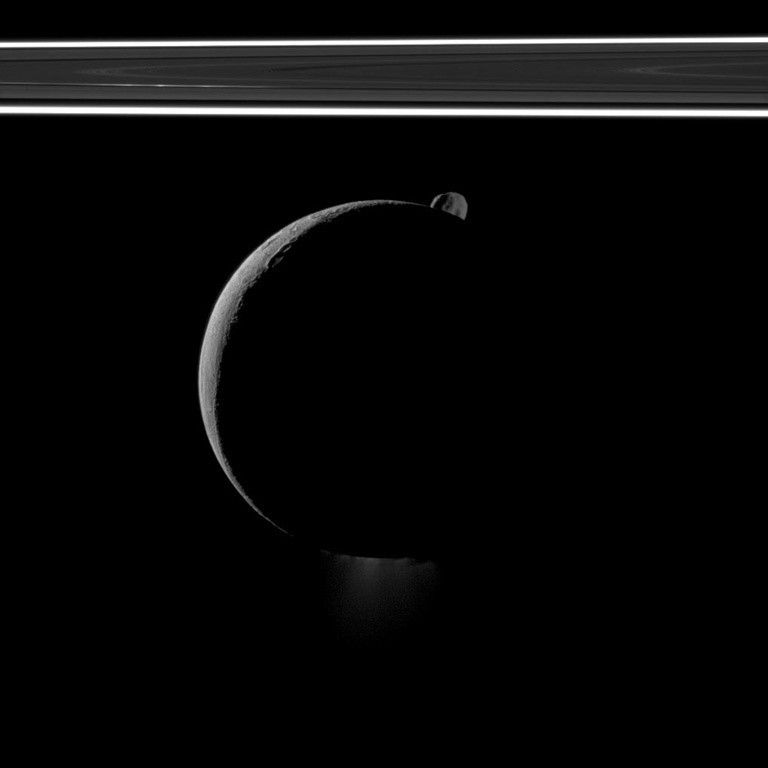
Enceladus flyby (46 miles, or 74 kilometers) – E-17: The Fields, Particles and Waves instruments (a.k.a. Magnetosphere and plasma science [MAPS]) are prime (particularly the ion and neutral mass spectrometer [INMS] ) to study the composition, density, and variability of plumes. With E-14 and E-18, this flyby provides good coverage of south polar regions. The "prime" instruments choose the spacecraft's pointing, giving its science the highest priority.
- Other highlights (March 26-29)
- During dark approach, CIRS will be observing to monitor hot spots, and during the lit exit, ISS will be prime with ORS “ride-alongs.” The dark approach is also an ideal time for another plume observation. There is a long (5-hour) observation at a solar phase angle ranging from 154 to 160 degrees. This wide range in solar phase angles will enable a good measurement of the forward scattered solar phase function of the particles, which in turn can be used to derive their sizes. Time variability of the plume can also be studied.
- The segment starts with the first of a pair of Titan cloud monitoring campaign observations, enabling study of cloud evolution over periods of days. There is also a pair of ISS observations searching for Lagranian satellites in the L5 points of Titan and Rhea.
- There is a Janus observation (03:40 hour duration), with a closest approach of 27,340 miles (44,000 kilometers), the best yet.
- A Radar scatterometry measurement of Dione complements the observations of other icy moons and Titan, enabling comparisons. This is followed by an ORS regmap of Dione.
- There is a short (45 minute) CIRS observation of Rhea (to complete coverage) and an ISS calibration on Rhea after that.
- Finally, Radar executes an engineering test on Saturn at the end of the segment.
April 14
Enceladus flyby (46 miles, or 74.0 kilometers) – E-18: The Fields, Particles and Waves instruments (a.k.a. MAPS) are prime (particularly the ion and neutral mass spectrometer [INMS]) to study the composition, density, three-dimensional structure and variability of plumes; with E-14, and E-17, this flyby provides good coverage of south polar regions.
- Other highlights:
- During dark approach, CIRS will be observing the anti-Saturnian hemisphere to monitor hot spots, and discover new ones.
- During the exit leg, observations of a Tethys untargeted flyby will take priority, with CIRS, VIMS, and ISS taking turns at prime observations to better map the Tethys “pacman”, which is due to a different thermal inertia and possible bombardment of high-energy electrons. Those instruments will also study the composition and morphology of Tethys.
- Other observations include a plume observation at low latitude and a variety of spatial scales for context; searches for satellites at Rhea’s Lagrange points; and two Titan cloud monitors.
- There is also a Saturn discipline VIMS atmosphere occultation.
May 2
Enceladus flyby (46 miles, or 74 kilometers) – E-19: E-19 is a radio science (RSS) gravity flyby, one of a pair designed to understand the internal structure of Enceladus, particularly the concentration of mass under the south polar region. RSS will have its usual three periods of observation: two wings and closest-approach. The MAPS pointing will be optimized to gather data near closest approach.
- Other highlights:
- During the dark approach, CIRS will be observing the anti-Saturnian hemisphere to monitor hot spots, and discover new ones to understand the global energy balance of Enceladus. During the exit leg, CIRS will be observing near the equator during the day (again to understand the global energy balance).
- After E-19, there is a 5,010 mile (8,063 kilometer) Dione untargeted flyby with ISS and CIRS prime. This flyby is designed to seek hot spots and possible emission from Dione, and to map poorly observed regions.
- Other observations include a plume observation similar to one taken on the previous pass, to understand plume variability on the scale of weeks; and two 10-hour irregular satellite observations to derive their lightcurve and rotational states, to give further information on the collisional environment in the outer Saturnian system.
May 20-21
non-targeted flyby segment highlights:
- CIRS observation (about 5 hours) of Tethys to characterize its spatially resolved thermal inertia and global energy balance. ORS ride-alongs.
- This segment also includes ORS observations of Methone at 1,181 miles (1900 kilometers) to give the first good close-up of this body, and the first spectra in the ultraviolet (UV) , visible (VIS) and infrared (IR). This is a unique small moon between Mimas and Enceladus.
May 22
Titan flyby (593.4 miles, or 955.0 kilometers) – T-83: Radar uses synthetic aperture radar (SAR, a technique which uses that spacecraft's flight path to simulate a very large radar aperture) to detect changes in small lakes seen on the T-16 and T-19 flybys. There is some overlap with territory seen in T-95. Other RADAR observations include inbound and outbound radiometry, high synthetic aperture radar (HiSAR, a method like SAR that can be used when the target is too far away or at the wrong angle for conventional SAR) and altimetry, along with outbound scatterometry. Inbound, VIMS looks for specular reflection on the Northern lakes and also looks to detect clouds to monitor climatic changes after the equinox. ISS rides along with VIMS' and CIRS’ observations to image Titan's surface and atmosphere, including Adiri and the region where changes were observed in Fall 2010. With closest approach slightly in the dayside ionosphere, the dual technique magnetometer (MAG) will be able to study the diffusion of the external magnetic field at low altitudes and high solar zenith angles.
June 7
Titan flyby (595.8 miles, or 959.0 kilometers) – T-84: Radar is prime around closest approach and will acquire SAR of the sparsely-covered Northwest quadrant (plus global shape from synthetic aperture radar topography [SARtopo, a technique that gives topology data along with the SAR image]), altimetry on Adiri, and HiSAR on equatorial regions.
Outbound from T-84, Radar will do altimetry on Adiri, and HiSAR on equatorial regions. ISS will ride along with CIRS and UVIS and their outbound leg includes low-phase-angle observations of Adiri and the region where extensive surface changes were observed in Fall 2010. For MAG, T-84 is another low altitude north polar flyby in the post noon sector of Saturn's magnetosphere. With closest approach slightly in the dayside ionosphere, Cassini will be able to study the diffusion of the external magnetic field at low altitudes and high solar zenith angles. ISS will monitor Titan to track clouds and the evolution thereof for an extra day after the Titan encounter.
July 24
Titan flyby (628.8 miles, or 1,012.0 kilometers) – T-85: VIMS observations will focus on detection of clouds to monitor climatic changes after the equinox, as well as looking for specular reflection on the Northern lakes. VIMS is prime at closest approach and will acquire 1kilometer-per-pixel images of the Huygens landing site to look for geological changes and spin rate determination by comparing with previous T-47 observation. This is one of VIMS’ so-called “10-pointer” flybys, i.e. one of the two scientifically most significant Titan flybys for VIMS during the Solstice mission. CIRS performs far-infrared limb-sounding to retrieve vertical temperature, aerosol and gas distribution near 36 degrees north latitude. T-85 is another low altitude (615 miles, or 990 kilometers) north polar flyby in the post noon sector of Saturn's magnetosphere. With closest approach in the dayside ionosphere, Cassini will be able to study the diffusion of the external magnetic field at low altitudes and mid solar zenith angles. A comparison with T-83 and T-84 will be very useful for MAG.
Sept. 26
Titan flyby (594.0 miles, or 956.0 kilometers) – T-86: T-86 has a dayside pass through the mid and high Northern latitudes. This pass will be critical to INMS monitoring the effect of solar input on Titan’s atmosphere. The T-86 flyby observations are part of a strategy which is intended to determine how Titan's atmosphere depends on latitude. INMS is prime inbound and outbound, so this will be one of a handful of opportunities to profile the ionosphere through the outermost edge of Titan's atmosphere (the exobase), to closest approach and back out through the egress exobase crossing.
RADAR will ride along with INMS, conducting SAR change detection on the southwestern part of Ligeia Mare (seen on T-28). ISS will ride along with CIRS' and UVIS' observations, inbound and outbound, to image Titan's surface and atmosphere. The outbound leg includes Adiri and the region where extensive surface changes were observed in Fall 2010. ISS will also monitor Titan to track clouds and the evolution thereof for an extra day after the Titan encounter.
Nov. 13
Titan flyby (604.6 miles, or 973.0 kilometers) – T-87: T-87 is one of two passes in the Solstice Mission where INMS and the navigation team will simultaneously measure Titan’s atmosphere. This is critical to understanding the differences in the atmospheric density calculated by INMS, navigation (NAV), the articulation control subsystem (AACS), and UVIS. The flyby is one of NAV’s so-called “10-pointer” flybys, i.e. one of the two scientifically most significant Titan flybys for navigation during the Solstice mission. The navigation team isn't a science instrument, but they are very interested in Titan's atmosphere because they need to make sure that Cassini doesn't go into dense parts of the atmosphere that would make it difficult to safely control the spacecraft. So the navigation team uses the science instrument results on atmospheric density, and compares that with their own tracking data to model Titan's atmosphere. VIMS will carry out detection of clouds to monitor climatic changes after the equinox, looking for specular reflection on the northern lakes. ISS will ride along with CIRS' and VIMS' observations, inbound and outbound, to image Titan's atmosphere. The outbound leg includes the region where extensive surface changes were observed in Fall 2010.
Nov. 29
Titan flyby (630.0 miles, or 1,014.0 kilometers) – T-88: Inbound, CIRS carries out near-infrared vertical mapping of the atmosphere near the Huygens probe entry latitude at 11 degrees south latitude, to characterize vertical aerosol and gas profiles. Outbound, VIMS attempts detection of clouds to monitor climatic changes after the equinox. Look for specular reflection on the Northern lakes. VIMS is prime at closest approach and will acquire approximately one kilometer per pixel images of Adiri, west of the Huygens Landing site. ISS will ride along with CIRS' and VIMS' observations, inbound and outbound, to image Titan's surface and atmosphere. The outbound leg includes the region where extensive surface changes were observed in Fall 2010 and an area at mid-southern latitudes on the trailing hemisphere that has only been imaged at lower resolution. ISS will also monitor Titan to track clouds and the evolution thereof for an extra day after the Titan encounter.
Plume Observations: Why so many? (recap)
- To obtain different viewing geometries that better characterize plume morphology, particle size, and the relationship between plumes and surface features and thermal anomalies. Specific jets are mapped to specific locations. In addition, large distances are required for context and to understand the relationship of the plumes to the E-ring.
- To understand the variability of geologic activity on Enceladus, the same viewing conditions at different times are required.
- Observations of both jets and plumes are required.
Spacecraft Event Time
Dates are listed in Spacecraft Event Time (SCET), which is the time the something happens at the spacecraft based on Coordinated Universal Time (UTC).


