


Description
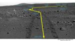
This image is a traverse map, illustrating Spirit's path over the last 45 sols. When the rover reached the point called "Laguna Hollow," it had driven 131 meters (430 feet) from Columbia Memorial Station. The rover heading is 45 degrees to the northeast. On the horizon behind the lander looms the landmark informally named "Grissom Hill." Over the relatively flat traverse, Spirit has made observations of rocks such as "Adirondack" and utilized the tools on its arm to investigate soil in several locations. Spirit stayed at "Laguna Hollow" for 3 sols, dug a trench and observed the floor and wall of it with three of the instruments on its arm: the Moessbauer spectrometer, the alpha particle X-ray spectrometer and the microscopic imager. Spirit is about halfway to the edge of the crater dubbed "Bonneville."


