


Description
MGS MOC Release No. MOC2-507, 8 October 2003
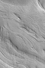
The Mars Global Surveyor (MGS) Mars Orbiter Camera (MOC) experiment was designed to study the geology and geomorphology of Mars by providing images comparable in resolution to the aerial photographs used by terrestrial geologists in conducting their field work. For over six years, the MOC narrow angle camera has been returning pictures that underscore, time and again, the layered nature of the upper martian crust. It is from layered rock that geologists will one day be able to decipher the history of the red planet. This example of layered rock exposures occurs in eastern Candor Chasma, one of the troughs of the Valles Marineris system. The picture is located near 8.0°S, 67.0°W, and covers an area 3 km (1.9 mi) wide. The image is illuminated by sunlight from the lower left.


