


Description
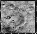
Mariner 4 image of the crater named after it, the 151 km diameter Mariner crater at 35 S, 164 W. Running from the lower left corner of the frame through the bottom of the crater is a linear ridge which is part of Sirenum Fossae. The image was taken from 12,600 km and covers 250 km by 254 km. North is up. (Mariner 4, frame 11E)
Mariner 4 was the first spacecraft to get a close look at Mars. Flying as close as 9,846 kilometers (6,118 miles), Mariner 4 revealed Mars to have a cratered, rust-colored surface, with signs on some parts of the planet that liquid water had once etched its way into the soil.
Mariner 4 was launched on November 28, 1964 and arrived at Mars on July 14, 1965.


