


![Request for Information – Potential [Placeholder for Prize]](https://assets.science.nasa.gov/dynamicimage/assets/science/psd/solar/2023/09/s/solarsystem_0.jpg?w=1024)


Description
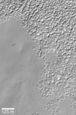
MGS MOC Release No. MOC2-355, 9 May 2003
This Mars Global Surveyor (MGS) Mars Orbiter Camera (MOC) image shows a typical southern mid-latitude surface at very high resolution. The smooth-surfaced material (mostly on the left and lower left sides of the image) erodes and breaks down into the knobby terrain (seen at the top and right). The exact cause of this degradation of smooth-surfaced material at middle latitudes is unknown. One speculation is that the materials are a mixture of water ice, dust, and silt; when the ice sublimes away, it leaves behind the knobby terrain. The image is located near 37.0°S, 84.0°W. Sunlight illuminates the scene from the upper left.


