


Description
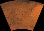
Mars digital-image mosaic merged with color of the MC-27 quadrangle, Noachis region of Mars. Heavily cratered highlands dominate the Noachis quadrangle. The northeastern part is marked by the western half of the ancient large Hellas basin, defined by a rim of rugged mountain blocks that surrounds a nearly circular expanse of light-colored plains. The southeastern part is marked by the Peneus caldera and part of the Amphitrites shield volcano and associated ridged plains that may be basaltic flows. Latitude range -65 to -30 degrees, longitude range -60 to 0 degrees.


