


Description
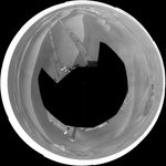
NASA's Mars Exploration Rover Opportunity used its navigation camera to take the images combined into this 360-degree view of the rover's surroundings on the 1,850th Martian day, or sol, of its surface mission (April 7, 2009).
Opportunity had driven 62.5 meters (205 feet) that sol, southward away from an outcrop called "Penrhyn," which the rover had been examining for a few sols, and toward a crater called "Adventure." In preceding drives, the drive motor for the right-front wheel had been drawing more current than usual, so engineers drove Opportunuity backward on Sol 1950, a strategy to redistribute lubricant and reduce friction in the wheel.
North is at the top of the image; south at the bottom. Opportunity's position on Sol 1850 was about 1.3 kilometers (0.8 mile) south-southwest of Victoria Crater. For scale, the distance between the parallel wheel tracks is about 1 meter (about 40 inches).
This view is presented as a polar projection with geometric seam correction.


