


Description
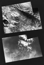
This mosaic of Mariner 9 frames (top), taken during the first orbit, shows the remnants of the south polar cap of Mars dimly through the great dust storm. Mariner 7 photographed the same area in August, 1969 (bottom) at which time the entire region was covered with dry ice. The strange quasilinear features of 1969 have been replaced by a number of bright curved appendages never before seen on Mars and, at this time, unexplained.
Mariner 9 was the first spacecraft to orbit another planet. The spacecraft was designed to continue the atmospheric studies begun by Mariners 6 and 7, and to map over 70% of the Martian surface from the lowest altitude (1500 kilometers [900 miles]) and at the highest resolutions (1 kilometer per pixel to 100 meters per pixel) of any previous Mars mission.
Mariner 9 was launched on May 30, 1971 and arrived on November 14, 1971.


