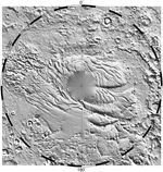
Photojournal NavigationSciencePhotojournalSouth Polar Topography (MOLA)Photojournal HomePhotojournal SearchLatest ContentGalleriesFeedbackRSSAbout 1 Min Read South Polar Topography (MOLA) PIA02052 Credits: NASA/JPL/GSFC Image Addition Date:06/23/1999Target:MarsIs a satellite of:SunMission(s):MGS (Mars Global Surveyor)Spacecraft(s):Mars Global Surveyor (MGS)Instrument(s):Mars Orbiter Laser AltimeterDataset:MGS (Mars Global Surveyor) Downloads South Polar Topography (MOLA) JPEG (1.18 MB) South Polar Topography (MOLA) TIFF (5.14 MB) Description Relief model of the topography of the South Polar Region showing the form of the ice cap and its surroundings. The circular area at the pole has not yet been mapped. Keep Exploring Discover More Topics From Photojournal Photojournal Search Photojournal Photojournal’s Latest Content Feedback