


Description
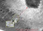
Scientists created this overlay map by laying navigation and panoramic camera images taken from the surface of Mars on top of one of Spirit's descent images taken as the spacecraft descended to the martian surface. The map was created to help track the path that Spirit has traveled through sol 44 and to put into perspective the distance left to travel before reaching the edge of the large crater nicknamed "Bonneville."
The area boxed in yellow contains the ground images that have been matched to and layered on top of the descent image. The yellow line shows the path that Spirit has traveled and the red dashed line shows the intended path for future sols. The blue circles highlight hollowed areas on the surface, such as Sleepy Hollow, near the lander, and Laguna Hollow, the sol 45 drive destination. Scientists use these hollowed areas - which can be seen in both the ground images and the descent image - to correctly match up the overlay.
Field geologists on Earth create maps like this to assist them in tracking their observations.


