


Description
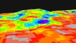
This digital elevation map shows the topography of the "Columbia Hills," just in front of the Mars Exploration Rover Spirit. Colors indicate the slopes of the hills, with red areas being the gentlest and blue the steepest. Rover planners are currently plotting the safest route for Spirit to climb the front hill, called "West Spur." The direct path straight up through the blue area may be too steep. Data from the Mars Orbital Camera on the orbiting Mars Global Surveyor were used to create this 3-D map.


