Science in Action
Filters

Scientists say the seasonal crop fires are burning later in the day than in previous years.

As wildland fires raged in the American West, NASA airborne technology was there to image it in incredible detail.

Data provided by the water satellite are helping to improve tsunami forecast models.
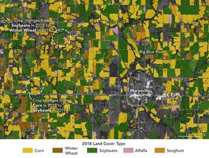
That’s a key question for many farmers, and new research may make it easier to develop growing season plans.

NASA airborne technology revealed the progression of a controlled fire at Fort Stewart-Hunter Army Airfield.
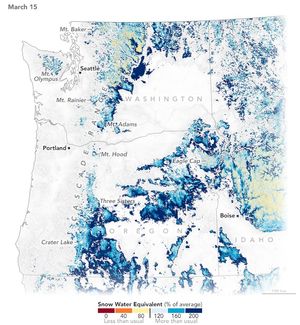
A warm and dry spring in the Pacific Northwest quickly depleted the seasonal snowpack, raising concern over summer water supplies…

Scientists used Landsat satellite images to detect both abrupt and gradual changes and to examine how phenomena, from storms to…

Researchers used NASA satellite data to detect swarms of red-tinged copepods, a key food source for the endangered marine mammals,…

Satellite-derived maps of nighttime lights in southern Spain revealed power outages that persisted across rural areas as the region was…