ICESat
Filters

Loss of ice at the periphery of the Greenland Ice Sheet was often discounted; recent research suggests it should not…

Scientists project ice losses from the Greenland and Antarctic Ice Sheets will play a large part in sea level rise…

Mangrove forests are among the planet’s best carbon scrubbers.

Researchers studying tropical forests have mapped out a way to preserve significant amounts of carbon-rich vegetation and biodiversity by connecting…

A high-resolution map offers a global view of forest canopy heights.

To understand how fast-moving glaciers are changing the ice sheets, scientists devised a method to map elevation change using data…
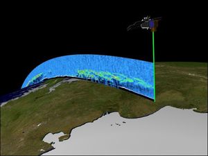
Orbiting the Earth at nearly 17,000 miles per hour, NASA's Ice, Cloud and land Elevation Satellite (ICESat) is collecting spectacular…