Tsunamis
Filters

Data provided by the water satellite are helping to improve tsunami forecast models.

Satellite data show the shape of a wave as water sloshed around Dickson Fjord after a rockslide triggered a tsunami…

The 56-foot wave in Pedersen Lagoon, on Alaska’s Kenai Peninsula, damaged trees and left a mark on the landscape.

One of the hardest hit coastal cities in Japan is still working to recover.

Landsat images helped convince researchers that a slumping mountainside overlooking Barry Arm fjord could pose a tsunami hazard.

Sobering satellite views reveal massive damage on the Indonesian island of Sulawesi.

Computer models describe the projected path of objects washed out into the Pacific Ocean by the March 2011 tsunami in…

Even at great distances from their source, tsunami waves can grow by being focused and steered by underwater ridges.
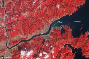
One year after the tsunami, the landscape near the mouth of the Kitakami river remains irrevocably altered.