AVIRIS-3
Filters
AVIRIS-3 Sensor Captures Data on Wildfire Near Mount Vernon, Alabama
2 min read
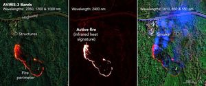
At one of the Mount Vernon, Alabama, fires, firefighters used AVIRIS-3 maps to determine where to establish fire breaks beyond…
Apr 23, 2025
Article
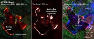
AVIRIS-3 Sensor Captures Data on Wildfire Near Perdido, Alabama
2 min read
As firefighters worked to prevent a wildfire near Perdido, Alabama, they saw in an infrared fire map from NASA's AVIRIS-3…
Apr 23, 2025
Article
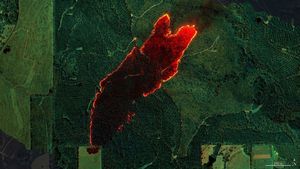
AVIRIS-3 Sensor Captures Data on Wildfire Near Castleberry, Alabama
2 min read
NASA's AVIRIS-3 airborne imaging spectrometer was used to map a wildfire near Castleberry, Alabama, on March 19, 2025. Within minutes,…
Apr 23, 2025
Article