EMIT (Earth Surface Mineral Dust Source Investigation)
Filters

Perched on the International Space Station, NASA's EMIT can differentiate between types of vegetation to help researchers understand the distribution…

NASA's EMIT collected this hyperspectral image of the Amazon River in northern Brazil on June 30, 2024, as part of…

NASA's EMIT produced its first global maps of hematite, goethite, and kaolinite in Earth's dry regions using data from the…
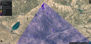
EMIT identified a cluster of 12 methane plumes within a 150-square-mile (400-square-kilometer) area of southern Uzbekistan on Sept. 1, 2022.…

The cube shows methane (purple, orange, yellow) over Turkmenistan. The rainbow colors are the spectral fingerprints from corresponding spots in…

This image shows a 2-mile (3-kilometer) long plume of methane southeast of Carlsbad, New Mexico. Methane is a potent greenhouse…

The image cube's front panel is a true-color view of part of southwestern Libya observed by NASA's EMIT mission. The…

Installed on the space station in July 2022, EMIT orbits Earth about once every 90 minutes, to map the world's…

NASA's EMIT mission recently gathered mineral spectra in northwest Nevada that match what the agency's AVIRIS instrument found in 2018,…