2 min read
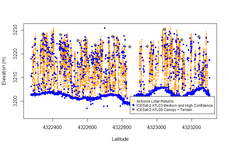
Thanks to tree height data collected by 9th-grade algebra students (from Monsignor McClancy Memorial High School 9th grade algebra students in Queens, New York) participating in the Global Learning and Observations to Benefit the Environment (GLOBE) Program, a new peer-reviewed paper is showcasing the accuracy of citizen scientist observations of tree height. This paper, co-authored by the school's head of Humanities and STEAM Department and one of the students' teachers there, focuses on a comparison of tree height data from space, aircraft, and the ground, including the 76 tree height observations the students made using GLOBE Observer - a citizen science app that allows volunteers to take observations and contribute to the GLOBE community. The paper, “The potential of citizen science data to complement satellite and airborne lidar tree height measurements: Lessons from The GLOBE Program”, was published on June 21st, 2022, in Environmental Research Letters: Focus on Public Participation in Environmental Research.
Access the paper: https://iopscience.iop.org/article/10.1088/1748-9326/ac77a2
Learn more about the GLOBE Program and how you, too, can do real NASA science and even become a published scientist on your next citizen science adventure: https://www.globe.gov/home
GLOBE Observer is funded as part of the NASA Earth Science Education Collaborative (NESEC). NESEC (https://science.nasa.gov/science-activation-team/nesec) is supported by NASA under cooperative agreement award number NNX16AE28A and is part of NASA's Science Activation Portfolio. Learn more about how Science Activation connects NASA science experts, real content, and experiences with community leaders to do science in ways that activate minds and promote deeper understanding of our world and beyond: https://science.nasa.gov/learners


