


Introduction
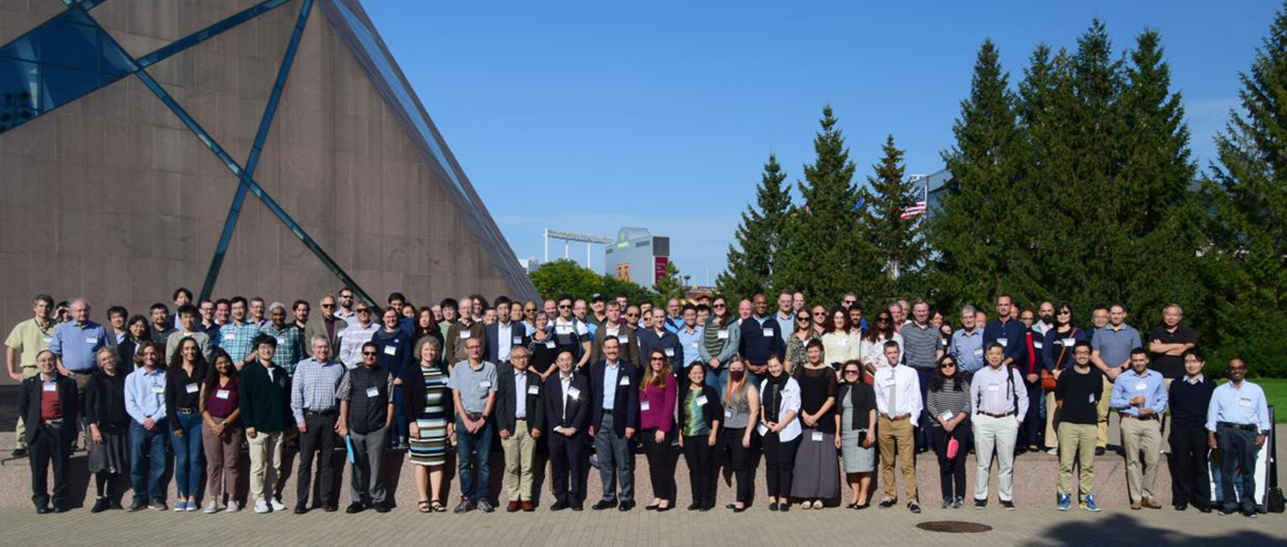
The annual Precipitation Measurement Mission (PMM) Science Team Meeting (STM) took place September 18–22, 2023, in Minneapolis, MN. The PMM program supports scientific research and applications, algorithm development, and ground-based validation activities for the completed Tropical Rainfall Measuring Mission (TRMM) and current Global Precipitation Measurement (GPM) mission, including the GPM Core Observatory. Participants (including 137 in person and 22 virtual attendees) joined the meeting from a variety of affiliations including NASA, the Japan Aerospace Exploration Agency (JAXA), universities, and other partner agencies—see Photo.
The meeting included 46 plenary presentations spread across 7 thematically focused sessions and 77 poster presentations split between 2 sessions, with both oral and poster sessions covering mission and program status, partner reports, GPM algorithm development, and scientific results using GPM data.
The meeting also included a series of splinter sessions for precipitation working groups. The working groups included NASA–JAXA Joint Precipitation Science Team, the Committee on Earth Observation Satellites–Precipitation Virtual Constellation, GPM Mentorship Program, and topically focused groups on Applications, Hydrology, Land Surface, Latent Heating, Multisatellite, GPM Intersatellite Calibration (XCAL), Ground Validation (GV), Particle Size Distribution (PSD), and Oceanic Areas. These working groups were a combination of invitation-only, in-person, and hybrid meetings. Owing to the distributed nature of these meetings, summaries of their proceedings are not included in this article.
This article highlights current updates on the GPM mission and summarizes scientific results conveyed during the 2023 PMM STM. The meeting agenda and full presentations can be accessed through the 2023 PMM Science Team Meeting Files. Note that this is a password protected page; readers interested in accessing these files will need to reach out via the GPM Contact Form on the website to receive the access code.
Status Report and Updates on PMM: Perspectives from NASA and JAXA
The PMM missions are the fruit of long partnerships between NASA and JAXA. The PMM Science Team (ST) includes more than 20 international partners. The subsections that follow highlight the status of the PMM program and related activities that were conveyed by NASA and JAXA PMM Science Program Management Teams.
NASA
Will McCarty [NASA Headquarters (HQ)—GPM Program Scientist] presented the NASA HQ perspective regarding PMMs – present and future. He explained that current missions continue to drive the focus for precipitation science, and that future missions will continue to link the thermodynamic and dynamic factors of precipitation science by targeting additional temporal information. McCarty introduced several current and upcoming missions and programs, including satellite launches [e.g., NASA’s Time-Resolved Observations of Precipitation structure and storm Intensity with a Constellation of Smallsats (TROPICS), an Earth Venture Instrument (EVI), and the Investigation of Convective Updrafts (INCUS), an Earth Venture Mission], instruments [e.g., NASA’s Polarized Submillimeter Ice-cloud Imager (POLSIR), also an EVI, which will be deployed on two CubeSats], and field campaigns [e.g., NASA’s Investigation of Microphysics and Precipitation for Atlantic Coast-Threatening Snowstorms (IMPACTS) and Convective Processes Experiment Cabo Verde (CPEX-CV) experiments]. He then briefly discussed the second (2017) Earth Science Decadal Survey and provided an overview of the future Earth System Observatory (ESO), which will have interconnected core missions (e.g., the Atmosphere Observing System (AOS)). He also discussed the Planetary Boundary Layer (PBL), which the Decadal Survey classifies incubation targeted observable. McCarty concluded by noting that the future PMM ST call may be integrated by combining mission science from multiple satellites.
George Huffman [NASA's Goddard Space Flight Center (GSFC)—GPM Project Scientist and PMM ST Lead] provided an update on the projected lifetime for GPM. Based on fuel usage alone, GPM should continue to December 2027. However, the amount of solar activity has an impact on that calculation. The Sun is expected to be quite active over the next few years as we approach the Solar Maximum for Solar Cycle 25—which could shorten GPM’s lifetime by as much as four years. He noted that a controlled reentry of the GPM Core spacecraft is planned—and enough fuel has to be kept in reserve to allow this to happen. Huffman discussed a recently developed plan for boosting the orbit of the GPM core satellite—for more details on the plan, see the subsection, “GPM Core Observatory Boost,” later in this article. He added that NASA and JAXA have both approved the plan and deemed its implementation critical for overlap with AOS for instrument intercomparison. The boosting is currently scheduled for November 7–9, 2023.(Update: Since the meeting in September, the GPM orbit boost was executed successfully on the scheduled dates.) The impact of the boosting on radiometer algorithms (e.g., for the GPM Microwave Imager (GMI)) is expected to be less than the impact on the radar algorithms (e.g., for the GPM Dual-Frequency Precipitation Radar, (DPR)). The potential impact on the combined algorithms (i.e., algorithms used to combine data from GMI and DPR) is still being assessed.
Huffman also discussed the status of the GPM data products. He reported that all GPM core data products are using Version 7 (V07). He mentioned that V07 of the Integrated Multi-Satellite Retrievals for GPM (IMERG) Final is out, but IMERG Early and Late data products are pending other actions in the NASA Precipitation Processing System (PPS). (IMERG has 3 classifications of data products: Early (latency of 4 hours), late (latency of 12–14 hours), and final (latency of 3 months).) He noted that the GPM orbit boost requires modifications to V07 core algorithms, and this accentuates the importance of a timely release of V08 algorithms (anticipated early 2026).
Erich Stocker [GSFC—GPM Deputy Project Scientist for Data and Precipitation Processing System Project Manager] discussed the status of GPM data products. He mentioned that radar/combined/IMERG products have transitioned from V06 to V07—but all radiometer products, Level-1 to Level-3, went from V05 to V07 to ensure the version is consistent on all of the products. Stocker continued that the GPM core satellite boost in November 2023 will lead to an outage of radar products for about five months for research and 2–3 months for near real-time (NRT) data products. NRT radiometer products will continue through the boost with only 2–3 days of outage while the satellite reaches its new altitude. He concluded that the initial NRT V07 IMERG processing and V07 retroprocessing of Early and Late IMERG products will start in January 2024.
David Wolff [NASA’s Wallops Flight Facility (WFF)—GPM Deputy Project Scientist for Ground Validation and Ground Validation System Manager] provided an overview of the GPM Ground Validation program and current activities. He stated that the ground validation (GV) program has state-of-the-art ground and remote sensing instruments to acquire precipitation and microphysics data to validate GPM retrievals. He described the ground validation site at NASA’s Wallops Flight Facility (WFF), which includes several radars, disdrometers (an instrument that measures drop-size distribution), and a Precipitation Imaging Processor (PIP) package. Wolff discussed the gauge-only systems, Platforms for In situ Estimation of Rainfall Systems (PIERS), activities for Increasing Participation of Minority Serving Institutions in Earth Science Division Surface-Based Measurement Networks, and pySIMBA – the GPM GV Support Software, an Open-Source Python Package to integrate and Analyze Precipitation Datasets that is available from GitHub. Wolff also provided a brief overview of the successful GPM GV Workshop that was held at Wallops Flight Facility on March 23–25, 2023. He continued by providing GPM Ground Validation Network (VN) updates and discussing VN captures of three-dimensional (3D) polarimetric information within DPR and GMI.
Wolff also noted that the GV program includes field campaigns (e.g., IMPACTS and Marquette, a five-year mini campaign conducted in collaboration with the National Oceanic and Atmospheric Administration’s (NOAA) National Weather Service (NWS)). He also discussed the new S-band radar network in Canada that offers access to high-quality radar data at relatively high latitudes over both land and sea. This data will be used as part of the VN for evaluation of GPM products. He concluded by discussing the Global Hydrometeorology Resource Center (GHRC) that archives past and current field campaign data and provides data quality control, metadata, campaign descriptions, and digital object identifier (DOI) assignments for each instrument/sensor.
Andrea Portier [GSFC—GPM Mission Applications Lead] and Dorian Janney [GSFC—GPM Outreach Coordinator] reflected on the 2022–2023 applications and outreach efforts and also discussed upcoming activities, including the – at the time of the meeting – upcoming tenth anniversary of the GPM Mission in February 2024. The applications team continues its focus on increasing awareness and use of GPM data and products across communities through user-engagement activities, including workshops (e.g., Applying Earth Observation Data for Research and Applications in Sustainable Development held at the 2022 Fall Meeting of the American Geophysical Union (AGU) in San Francisco, CA), trainings (e.g., 2023 GPM Mentorship Program), GPM application case studies, and GPM visualizations. A continuing and integral part of GPM outreach efforts is the numerous activities that reach hundreds of students and adults in a variety of formal and informal settings. This includes cooperative efforts with NASA’s Global Learning and Observations to Benefit the Environment (GLOBE) and hands-on activities at events (e.g., the Earth Day celebration at the Washington, DC’s Union Station). (To read more about the 2023 Earth Day celebration at Union Station, see A Pale Blue Dot in Washington: NASA’s Earth Day Celebration at Union Station, in the July–August 2023 issue of The Earth Observer [Volume 35, Issue 4, pp. 4–12].)
Many of these efforts will be highlighted and amplified during GPM’s tenth anniversary celebration. The GPM Applications and Outreach Team’s planning for the anniversary is underway. The intent is to highlight the vast capabilities of the GPM Mission and how GPM data can be used to address societal applications and improve the understanding of Earth’s water and energy cycles through a series of activities and resources starting in February 2024. These efforts include a reception at GSFC Visitor’s Center, a year-long monthly webinar series, feature articles, applications eBook, and a GPM video, among others. Details of these efforts will be posted through the GPM website.
JAXA
Takuji Kubota [JAXA—JAXA GPM Program Scientist] provided an update and a review of the PMM program status and mission objectives. He emphasized that this update included the perspectives of the Japanese PMM Science Program Management Team, including their roles in the development of DPR and its algorithms, GV, GPM data processing, and GPM data distribution systems. He also gave an update on current activities related to GPM data utilization and application across Japan and Asia. Kubota continued by describing the potential impacts on the DPR instrument because of the proposed orbit boost, noting that the instrument footprints and swath widths will increase proportionately with altitude change accompanied by a slight reduction in radar sensitivity. JAXA is preparing for these impacts with revised codes for L1 algorithms and planning for external calibrations before and after the orbit boost to examine calibrations of the DPR. Kubota also discussed the reprocessing of JAXA’s Global Satellite Mapping of Precipitation (GSMaP) data product (essentially the JAXA equivalent of IMERG) to enable a longer-term precipitation dataset, highlighting its completion in September 2023. GSMaP data is now available back to January 1998. Kubota discussed the future of Japanese precipitation measurements including: Earth Cloud, Aerosol and Radiation Explorer (EarthCARE), scheduled for launch in 2024; Global Observing SATellite for Greenhouse gases and Water cycle (OSAT-GW), planned for launch NET 2024; Advanced Microwave Scanning Radiometer (AMSR) series, which currently includes AMSR2 on the (GCOM-W) and will include AMSR3 on GOSAT-GW; and the previously discussed ESO AOS mission. He concluded with a discussion of JAXA’s plan for observing and celebrating GPM’s tenth anniversary.
Yukari Takayabu [University of Tokyo—JAXA GPM Project Scientist] highlighted results from recent science studies using DPR and GSMaP data products from the JAXA assembled GPM Program Science Team. She noted the use of DPR for extracting high-altitude precipitation information over Africa, capturing low-level precipitation statistics near the center of typhoons, narrowing the blind zone of the DPR to improve shallow precipitation detection in mountainous areas, validation studies of DPR, and retrieving frozen precipitation data using DPR. She concluded her presentation with highlights of GSMaP use for several applications, including the new GSMaP validation work in Japan to observe extreme rainfall, improvements to GSMaP through data-driven approaches, and data assimilation of GSMaP into the JAXA Realtime Weather Watch system.
Nobuhiro Takahashi [Nagoya University] presented an overview of significant updates to the DPM algorithm since the last PMM ST meeting, including changes in the latest V07 processing to accommodate the full-swath Ka-band operations – see Figure 1. He emphasized the impacts on the planning and development of V08 DPR algorithm with respect to the GPM orbit boost (described in George Huffman’s presentation). He noted that the major impacts to the performance of DPR include a degradation of measurement sensitivity and the “rain/no rain” classification. Takahashi concluded by saying that the release of V08 is expected in January 2026.

Kosuke Yamamoto [Earth Observation Research Center (EORC) and JAXA] summarized application activities initiated by the JAXA GPM Program Science Team. He discussed the use of GSMaP precipitation data to support and enhance several application areas, e.g., the operational use of GSMaP for flood and severe weather forecasting as well as the use of GSMaP in operational systems, including the JAXA Agro-meteorology Information Provision System (JASMIN), ASEAN Food Security Information System (AFSIS), and the Japanese’ Coast Guard’s Maritime Domain Awareness (MDA) initiative. Yamamoto also discussed the 2022 Japan–Australia–India–U.S. (QUAD) Joint Leaders’ Meeting Tackling Extreme Precipitation Events Workshop, an online event that took place March 1–3, 2023, and associated workshop reports focusing on the utilization of satellite observations across Pacific Islands.
GPM Algorithm Updates
Presenters during this session provided information and updates on various aspects of the five major algorithms of GPM. Full documentation and detailed updates for each algorithm are available at the Precipitation Data Directory.
Dual Frequency Radar Algorithm
The DPR algorithm team provided updates on DPR-related work, including the further refinement of the path-integrated attenuation (PIA) estimates used in the surface reference technique (SRT). They examined the effects of using the new AutoSnow algorithm – which uses satellite snowfall observations to create snowfall maps – on PIA estimations and changes in the surface type classification. Overall, the changes were small on the estimated precipitation profiles. Other algorithm refinements include the addition of a dry and wet snow category and wind speed. The team is currently examining how to recover Ka-band attenuation from the Ku-band. They stressed that results from this analysis are preliminary, and more work is needed to assess the utility of this technique. Finally, the team is discussing the implications of the GPM orbit boost on the DPR algorithm.
GPM Combined Radar–Radiometer Algorithm
The GPM Combined Radar–Radiometer Algorithm (CORRA) team discussed the changes and improvements to the CORRA V07 algorithm over the previous version. They highlighted the new AutoSnow algorithm and its impacts within CORRA V07. The team also examined the impact of the precipitation particle size distribution (PSD) initial assumptions on the estimation of snowfall as well as a machine-learning based initialization approach that improves the agreement between CORRA and NOAA’s Multi-Radar/Multi-Sensor System (MRMS) snow estimates. In addition, the team continues to examine a radiometer-only module to estimate light precipitation over oceans. This module will be included in the next version (V08) of CORRA. The team is also looking at the consequences of the GPM orbit boost.
Goddard Profiling Algorithm for GMI
The Goddard Profiling Algorithm (GPROF) team continues to work on well-known issues. The V07 update includes improvements in the a priori database to help constrain outputs from GPM constellation radiometers as well as inclusion of the radiometers on TROPICS and NASA’s Temporal Experiment for Storms and Tropical Systems–Demonstration (TEMPEST-D). The two new neural network-based implementations of GPROF in V08 are anticipated in roughly a year. The team reported that they have no issues with the GPM orbit boost.
Integrated Multi-Satellite Retrievals for GPM Algorithm
The IMERG algorithm team reported on V07, which includes a wide range of algorithm changes from V06. V07 includes retrospective reprocessing of the entire TRMM–GPM record and thus supersedes all previous versions. The team also reported that the algorithm changes improve the performance of IMERG estimates both in terms of its precipitation detection and systematic and random bias. The presenters noted improvements over frozen, orographic, and coastal surfaces. The team is now working on priority items that need completing in order to implement V08.
Convective–Stratiform Heating Algorithm
The GSFC Convective–Stratiform Heating (CSH) algorithm team provided an overview on latent heating (LH) retrievals. The presentation highlighted some of the details in updating to V07, including more accurate cloud-resolving model (CRM) simulations (using 3D domain rather than two-dimensional) and new detailed radiation retrievals. V07 is also “terrain aware,” meaning that the algorithm includes added details of radiative heating profiles and eddy transport terms. For V08, the CSH team plans to have a new 3D CRM database with a grid size of 250 m (820 ft) and look-up tables (LUTs) for non-surface raining columns for the tropical/summertime part of the algorithm as well as LUTs for terrain. These V08 improvements are still in development as of this meeting.
Science Results and Data Quality
A large component of the meeting was dedicated to presentations by NASA PMM-funded Principal Investigator (PI) teams on the science research and applications being achieved using PMM data. PI oral presentations were divided into four thematically focused topical sessions: Precipitation Microphysics, Snow and Hail, Storm Analysis, and Data Uncertainty. The subsections that follow highlight scientific results from each of these sessions. The reader is referred to the full reports online for more details.
Precipitation Microphysics
Presenters during this session described various techniques and new methodologies to study microphysical properties of precipitation including shape and size of precipitation particles (e.g., drop size distribution (DSD)), phase identification (e.g., liquid, solid, and mixed phase/melting), scattering properties, and precipitation rate, using both radar and radiometer observations. These property measurements play a pivotal role in improving precipitation retrieval algorithms, allowing scientists and decision makers to better understand and forecast storms.
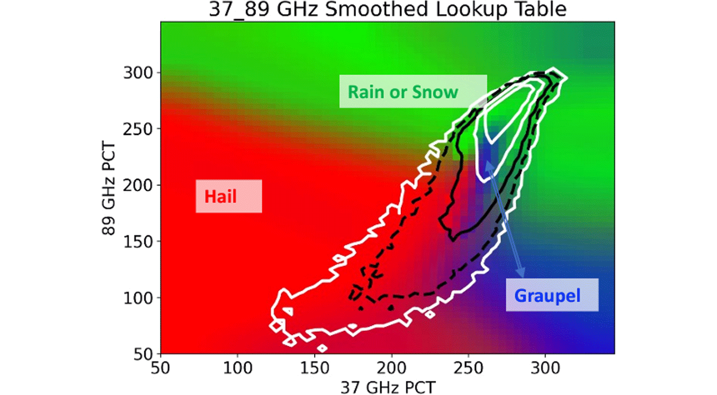
One presenter in this session discussed new methods for classifying different types of precipitation (e.g., rain, graupel, hail, and dry and wet snow) using DPR precipitation retrievals. The new technique will be implemented into the V08 DPR algorithm. The discussion also covered a technique to establish relationships between GMI brightness temperature and hydrometeor type (e.g., rain, snow, graupel, and hail), leveraging the GPM validation network to construct LUTs of hydrometeor type likelihood – see Figure 2. Another presenter introduced a model to understand how DSD changes near the surface can be used to estimate rainfall rate. The last presenter in this session discussed the development of a precipitation scattering property database—which includes scattering characteristics of about 10,000 different types of ice particles. The database includes scattering cross sections calculated in thousands of orientations for each type of particle. This database is accessible to the public, which helps support the development of physically based scattering calculations and improvement of precipitation retrieval algorithms for both radar and radiometers.
Snow and Hail
In this session, speakers discussed a broad move toward satellite retrievals for frozen hydrometeors, not just to identify bulk effects (e.g. snow or hail accumulation at the surface), but also to gather information on physical properties of frozen hydrometeors (e.g., where hailstones reside within clouds or what shapes snowflakes take). Understanding frozen hydrometeor properties can significantly improve precipitation and latent heat estimates that are essential for numerical weather forecasting and climate model development.
One speaker applied a method that used DPR and GMI observations to estimate frozen precipitation particle properties for an Olympic Mountain Experiment (OLYMPEX) field campaign case. The results he showed indicated a significant difference in the shapes of snowflakes between land and sea. Another speaker detailed the use of a simple machine learning framework trained on measurements of the use of snowfall and cloud type observations from the CloudSat Cloud Profiling Radar (CPR) to infer surface snowfall from GMI microwave measurements. Other presenters conveyed the results of a study examining different potential indicators of hail within the GPM database. These hail indicators were mapped, and the mean vertical profiles of radar reflectivity and storm structure were contrasted. The final pair of presentations focused on detecting hail in South America and Africa. In South America, hail-producing storms were shown to be strongly linked to local topography – in contrast to hotspots of hail in the U.S. Meanwhile, in Africa, new algorithms for identifying hail in GPM data suggest hail should be common – but this outcome is at odds with ground truth observations. This test case is being used to develop new methods for retrieving hail that include analyzing horizontal profile information within the data.
Storm Analysis
Presenters in this session discussed a variety of applications and assessments of PMM products for analyzing a variety of storms, particularly their cloud, precipitation, and kinematic structures and their structural evolution. The first speaker compared precipitation events simulated in IMERG to the same event with rain gauge observations. They found that while IMERG missed many winter precipitation events in mountainous regions –which rain gauges typically can measure – IMERG also captured summer virga events – which rain gauges typically miss. Another presenter compared IMERG to river catchment and integrated watershed observations and found that IMERG overestimated small precipitation events but underestimated large events. The next presenter showed a comparison IMERG simulations to the multi-instrument MRMS dataset during the lifecycle of precipitation events. The results shown suggest that IMERG errors in precipitation intensity could be improved by inputting other variables (e.g., ice water path or vertical velocity) into the precipitation retrievals. The discussions during this session also covered other plans to use PMM products to study convection in atmospheric river events, in combination with a modeling analysis using different convection schemes. The final pair of presenters spoke about understanding convective-scale drivers of the Inter Tropical Convergence Zone ascent and widening the use of a simple prognostic model that will use PMM data for filling terms in the model. One model weakness is the decay term for the convection cloud shield, which, if determined, could reduce error in climate models, particularly with radiative processes. The final speaker used TRMM Visible and Infrared Scanner (VIRS) data to develop and test a method for identifying and classifying cloud areas (i.e., core, midrange extent, and outer bound split window testing) and determine their relationships to other environmental variables, such as sea surface temperatures and column water vapor.
Data Uncertainty
Presenters during this session discussed new methodologies to address data uncertainties and bias in precipitation retrievals to improve precipitation estimates for science and applications research. Two of the presenters delved into the details of how the GPROF algorithm has inherent precipitation biases due to different hydrometeor characteristics captured by GMI passive microwave brightness temperature – which may be related to thermodynamic environments. Another PI presented updates for improving uncertainty estimates to enhance hydrological prediction. Specifically, he discussed multiscale precipitation uncertainties in precipitation products, including a new product that combines the Space-Time Rainfall Error and Autocorrelation Model (STREAM) with single-orbit rainfall estimates from the combined GPM data product, called STREAM-Sat. He explained how the uncertainties in these products can influence hydrologic prediction. The session concluded with a discussion of machine learning methods to estimate the probability distribution of uncertainties in passive microwave precipitation retrievals at different temporal and spatial scales.
Discussion of Future Missions, Observations, and Activities Relevant to GPM
This session featured presentations on several other existing and upcoming missions in various stages of development, as well presentations covering the future of precipitation instruments and observations, each with applications relevant to GPM. Each presentation included information on plans to advance and support precipitation science in the near term and the coming decade, as described below.
TROPICS
The TROPICS Pathfinder CubeSat mission provides microwave observations of tropical cyclones with less than a 60-minute revisit time to capture better storm dynamics and improve forecasting. The Pathfinder has demonstrated all mission elements and provided new tropical cyclone imagery (12,000+ orbits and counting). The Cal/Val team hopes to release the data to the public in Fall 2023. (UPDATE: Provisional TROPICS data was released in January 2024.) The TROPICS pathfinder satellite showed that the compact TROPICS design performs comparably to the state-of-the-art sounders. Lessons learned will help the TROPICS Team as they work to improve efforts and operate the TROPICS constellation, which now holds a total of five satellites.
AOS
As discussed in Will McCarty’s remarks, AOS is a key component of the Earth System Observatory that was recommended in the 2017 Decadal Survey. The mission will deliver transformative observations fundamental to understanding coupled aerosol– and cloud–precipitation processes that profoundly impact weather, climate, and air quality. Two AOS projects are in the mission concept and technology development phase (Phase-A): AOS-Storm (to launch late 2020s), with a Ku Doppler radar, microwave radiometers, and backscatter lidar in a 55° inclined orbit; and AOS-Sky (to launch early 2030s) with cloud-profiling Doppler radar, backscatter lidar, microwave radiometer, polarimeter, far infrared (IR) radiometer, and aerosol and moisture limb sounders in polar orbit. (This paragraph reflects what was discussed during the meeting, however, AOS is undergoing changes that will be reflected on the website at a later date.)
GPM Microwave Radiometer Constellation in the Next Decade
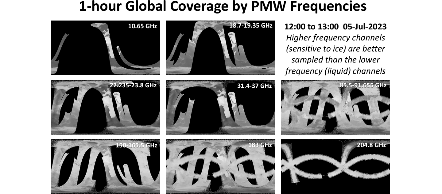
The future passive microwave radiometer constellation looks robust, with multiple sensors to be launched in the next decade. Small/CubeSat constellations are becoming a reality, and a plan to incorporate them quickly into the overall precipitation constellation is needed. A point of emphasis was that a sensor in an inclined orbit is a necessity when it comes to providing a reference measurement to support this effort – see Figure 3.
JAXA Precipitation Measuring Mission (JAXA PMM) Radar
Plans call for JAXA’s next generation of precipitation radar to be deployed as part of the agency’s future Precipitating Measuring Mission (PMM – yes, the same acronym as the Precipitation Measurement Mission). Objectives for this next-generation precipitation radar include Doppler observations, higher sensitivity measurements, and scanning capability. JAXA has collaborated with a Japanese science team and user community to explore the feasibility of a next-generation, dual-frequency precipitation radar. The discussion focused on the importance of measuring convection through Doppler velocities from spaceborne radar. The EarthCARE mission will feature the first Cloud Profiling Radar (CPR) with Doppler capability in space. JAXA has participated in NASA's AOS Pre-Phase A activities. The synergy between the GPM DPR and PMM/KuDPR is expected to contribute to the construction of a longer-term precipitation dataset by providing overlapping observations.
Update on Cloud Services at NASA GES DISC
NASA's Goddard Earth Sciences Data and Information Services Center (GES DISC), one of two data archive centers for GPM, is moving its data archive to the cloud – with all GES DISC data and services remaining free to all users. This will offer quick access to and subsetting capability for a large volume of data through multiple data access methods (e.g., Amazon Simple Storage Service) and cloud services. Multidisciplinary NASA data will be in one place – the Earthdata Cloud – and available for online analysis and in the cloud environment. Expanded services (e.g., access to the Common Metadata Repository–SpatioTemporal Asset Catalog (CMR-STAC), Harmony – a collective Earth Observing System Data and Information System (EOSDIS) effort to make data access more consistent and easier across all DAACs and Zarr – a data format designed to store compressed multidimensional arrays and thus well suited to cloud computing) are expected to be implemented in the near future. With the migration of GES DISC data to the cloud, some services may look different with details on the exact changes to services coming soon.
GPM Core Observatory Boost
As George Huffman discussed in his presentation, based on forecasted solar activity, the GPM Core Observatory could run out of fuel as early as October 2025 if the current orbit altitude is maintained. To prolong its operations, NASA and JAXA have decided to boost the GPM Core Observatory orbit by ~35 km (~22 mi), which places GPM at an altitude of ~435 km (~270 mi)) – placing it above the International Space Station orbital altitude. The post-boost operations of the satellite are expected to continue through the early 2030s. The boost is expected to last only 2–4 days and occur in the time window between November 2023 and March 2024 (likely November 7–9, 2023, as stated above), the boost will permanently change the sensors’ Field of Views (FOVs) and likely cause a gap of several months in DPR product delivery.
Precipitation in 2040
Sarah Ringerud [GSFC] and George Huffman led this plenary discussion that explored two questions: What comes next? and What does the cutting edge of precipitation science look like 20 years from now? CubeSats, reduced volume of low-frequency-channel observations, shorter sensor lifetimes, increased sampling, and calibration challenges are recognized as inevitable. Exciting new developments are seen in the opportunity for data fusion and interdisciplinary work. Interagency and private sector collaborations are foreseen as critical points for maintaining optimal monitoring of Earth precipitation.
Conclusion
The 2023 PMM STM brought together scientists from around the world to engage on a range of topics that advance the understanding of precipitation science, algorithms, and contributions to applications. The STM highlighted updates and activities enabled by the PMM scientific community. The closing session provided an opportunity for quick updates from precipitation working group members, who held splinter sessions. These updates were followed by an open discussion and review of PMM action items led by George Huffman. He reminded PMM STM participants of several important and noteworthy items, including updates on the orbit boost and subsequent algorithm adjustments, which will be available on the GPM website and be at the forefront for the project for the next six months; V08 of GPM data products are anticipated by early 2026; the budget reduction for the project – but not for current ROSES projects – will impact activities, including next year’s PMM STM; and the next NASA ROSES call might have a different package of opportunities, not strictly focused on PMM/GPM. He concluded by encouraging the PMM ST to share highlights and publications with the GPM Science Program Management Team as well as to continue to initiate collaborations with other colleagues to keep pushing the boundaries of science and outreach.
The next PMM STM will likely be held in September 2024. Details will be posted on the GPM website once they become available.

Acknowledgements The author would like to recognize the following individuals, all of whom made contributions to this article: Ali Behrangi [University of Arizona], Anthony Didlake [Penn State University], Gerry Heymsfield [GSFC], George Huffman [GSFC], Matthew Igel [University of California Davis], Toshio Iguchi [Osaka University], Dorian Janney [GSFC/ADNET Systems], Chuntao Liu [Texas A&M Corpus Christi], Veljko Petkovic [UMD], Courtney Schumacher [Texas A&M Corpus Christi], and Joe Turk [NASA/Jet Propulsion Laboratory].
Andrea Portier
NASA’s Goddard Space Flight Center/Science Systems and Applications, Inc.
andrea.m.portier@nasa.gov