2 min read
Technology Infused: On April 25, 2015, a magnitude 7.8 earthquake struck the mountainous nation of Nepal, causing widespread destruction and loss of life. Known as the Gorkha Earthquake, the event was the largest earthquake to strike the country in over 80 years. During the initial response to the quake, scientists processed data manually, developing images called interferograms one at a time to show deformations that occurred on the Earth’s surface as a result of the earthquake.
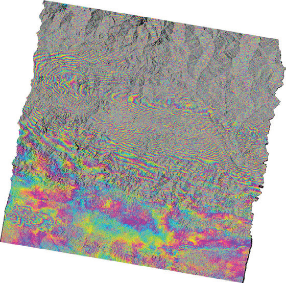
This interferogram shows part of the very large deformation caused by the 2015magnitude 7.8 earthquake in Nepal, including the capital city of Kathmandu.The color contours, or fringes, are 2.8 cm (1.1 inches) each and reflect thesurface deformation caused by fault slip at depths of 12-16 km. The area justnorth of Katmandu moved upward about 1.4 m due to the earthquake.(Credit: Hook Hua, JPL)
Within a week, the Advanced Rapid Imaging and Analysis (ARIA) project—a collaboration between NASA’s Jet Propulsion Laboratory and the California Institute of Technology— automated and customized many aspects of the process to increase efficiency. To achieve this improvement, the ARIA center utilized parts of a PSD-funded technology development project, ARIA for Monitoring Hazards (ARIAMH). ARIA-MH seeks to enable rapid generation of products to monitor hazards and for situational awareness during disasters. Specifically, ARIA-MH is developing a service-oriented hazard and disaster-monitoring data system that will enable both the scientific and decisionsupport communities to monitor ground motion using Global Positioning System (GPS) and Interferometric Synthetic Aperture Radar (InSAR) data.
Impact: Although the system is not yet fully operational, scientists leveraged ARIA-MH to rapidly process and reprocess interferograms generated using InSAR data from the European Union’s Copernicus Sentinel-1A satellite in a highly parallel cloud-computing environment. Scientists use these maps to build detailed models of faults, to show the ground motion caused by recent earthquakes, and to study the potential impact of future earthquake activity. The automation and scaled-up processing enabled by ARIA-MH significantly sped up the turnaround time required to process the Nepal earthquake data, enabling scientists to quickly assess new data and reprocess scenes with additional customizations and tweaks.
Status and Future Plans: The ARIA team is working to make these capabilities a fully operational part of the ARIA suite of tools.
Sponsoring Organization: The Earth Science Division supports development of ARIA-MH technology through the AIST program. Hook Hua of NASA JPL is PI for the ARIAMH project.
Share
Details
Last Updated
May 22, 2023
Editor
NASA Science Editorial Team


