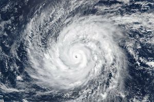





















On April 25, 2019, the Moderate Resolution Imaging Spectroradiometer (MODIS) on NASA’s Terra satellite acquired this natural-color image of Tropical Cyclone Kenneth just before landfall near the border of Mozambique and Tanzania. Around the time of the image, the U.S. Joint Typhoon Warning Center estimated sustained winds of 120 knots (140 miles/220 kilometers per hour). The cyclone had quickly intensified over the previous 36 hours to arrive as a category 4 storm.
Thousands of people were being evacuated from coastal areas as the storm approached. The eastern African countries were still recovering from devastating Tropical Cyclone Idai, which hit just a month ago.
References & Resources
- Forbes (2019, April 24) Cyclone Kenneth Threatens AfricaâWill the World Pay Attention This Time? Accessed April 25, 2019.
NASA Earth Observatory image by Joshua Stevens, using MODIS data from NASA EOSDIS/LANCE and GIBS/Worldview. Caption by Mike Carlowicz.