


.png?w=1024)


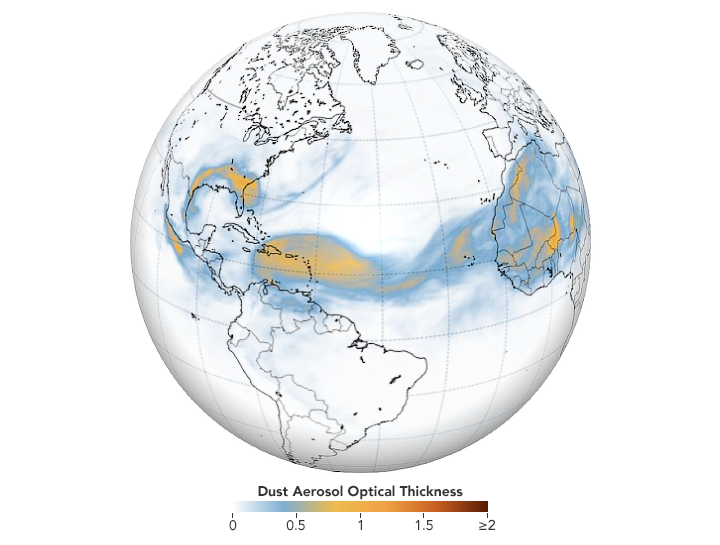
Winds routinely drive clouds of Saharan dust out of West Africa and across the Atlantic Ocean in the summer. But the intensity and extent of a plume that departed Africa in June 2020 was so great that it had internet meme-makers buzzing about a “Godzilla” dust cloud. From the International Space Station, NASA astronaut Doug Hurley described the vast ribbon of dust as “amazing.” And as dust blanketed the Caribbean Sea and darkened skies in several states in the U.S. Southeast, several meteorologists called the event “historic.”
Such superlatives are backed by data. One preliminary analysis of aerosol optical depth (AOD) measurements from NASA’s Moderate Resolution Imaging Spectroradiometer (MODIS) sensor showed a greater concentration of dust in the atmosphere over the Atlantic Ocean on June 20 than on any other day since 2003. AOD is a unitless measurement of how much light the airborne particles prevent from traveling through the atmosphere. A few days later, a ground-based AERONET sensor at Ragged Point, Barbados, recorded the all-time highest AOD value the site has recorded since 1996.
The plumes in June 2020 spanned thousands of kilometers. When the leading edge arrived in Puerto Rico and skies turned a hazy yellow-gray, beaches were closed and air quality plummeted. “This is the most significant event in the past 50 years,” Pablo Méndez-Lázaro, a University of Puerto Rico scientist told the Associated Press. “Conditions are dangerous on many Caribbean islands.” Méndez-Lázaro is working on a NASA applied sciences project to develop an early warning system for poor air quality in the region.
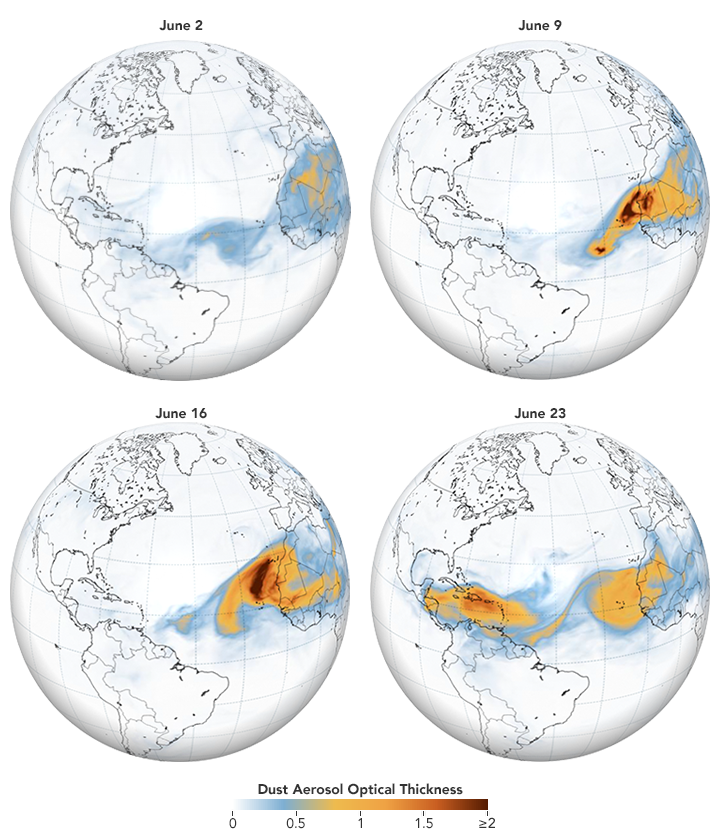
The sequence of images above, based on data from NASA’s Goddard Earth Observing System (GEOS) modeling system, shows pulses of Saharan dust at one-week intervals as they made their way across the Atlantic Ocean. Aside from Cape Verde, which regularly gets doused with dust, the islands in the Caribbean were some of the hardest-hit locations. As the plume reached the United States, the Environmental Protection Agency reported on June 27 that levels of fine particulate matter (PM2.5) had risen enough to reach “unhealthy levels” (between 151-200 on the air quality index) in Florida, Texas, and Georgia.
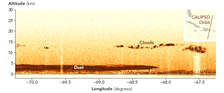
The data in the transect below reveal the height of the dust over the Dominican Republic as observed by the Cloud-Aerosol Lidar with Orthogonal Polarization (CALIOP) instrument on the CALIPSO satellite on June 23, 2020. Reaching roughly 4 kilometers (2.5 miles), the top of the plume was a bit higher than most; there was also plenty of dust at or below 1 kilometer (0.6 miles). As dust crosses the ocean, larger particles fall out first, leaving behind mainly finer and smaller ones, which are especially problematic for human health.
Air pollution experts are not the only specialists who are closely following this event. Meteorologists track dust storms because the dry, dusty air can inhibit the formation of clouds and prevent hurricanes. Infectious disease researchers watch them because dust plumes can be vectors for viral and bacterial diseases. And climate scientists study dust because big events can absorb enough light to affect Earth’s radiation budget.
Others will be watching for impacts on the oceans. “In nutrient-limited waters, iron and other nutrients in dust can trigger phytoplankton blooms with wide-ranging effects,” explained Hongbin Yu, a scientist at NASA Goddard Space Flight Center. Phytoplankton are critical to marine food webs and play an important—though little understood—role in the carbon cycle. “In this case, I do not expect to see much of a response from the Gulf of Mexico, which already has plenty of nutrients. But we could see a major response in a few weeks if enough dust passes over Central America and ends up in the more nutrient-limited waters of the eastern Pacific.”
Likewise, outbreaks of Saharan dust can play a key role in fertilizing the nutrient-poor soils of the Amazon rainforest in the winter and spring. However, Yu said seasonal wind patterns generally carries most of the dust from summer events north of the Amazon rainforest and into the Caribbean.
References & Resources
- Miami Herald (2020, June 25) Record Saharan dust plume cloaks Caribbean as health warnings issued. Miami may dodge worst. Accessed June 29, 2020.
- NASA (2020, June 26) Giant Saharan Dust Cloud Moves Over the Atlantic as Seen by MISR. Accessed June 29, 2020.
- NASA Earth Observatory (2020, January 9) A Dusty Journey.
- Scientific American (2020, June 24) Saharan Dust Plume Slams U.S., Kicking Up Climate Questions. Accessed June 29, 2020.
- The Atlantic (2020, June 24) A Giant Dust Storm Is Heading Across the Atlantic. Accessed June 29, 2020.
- The Washington Post (2020, June 25) Saharan dust plume, the largest in decades, spills over Gulf Coast. Accessed June 29, 2020.
- Wired (2020, June 25) Why Massive Saharan Dust Plumes Are Blowing Into the US. Accessed June 29, 2020.
- World Meteorological Organization WMO issues airborne dust bulletin as historic event hits Caribbean. Accessed June 26, 2020.
- Yale Climate Connections (2020, June 29) Saharan dust cloud was most intense in decades, and second cloud could arrive in July. Accessed June 29, 2020.
- Yu, H. et al (2020) Interannual variability and trends of combustion aerosol and dust in major continental outflows revealed by MODIS retrievals and CAM5 simulations during 2003-2017. Atmos. Chem. Phys. 20, 139-161.
NASA Earth Observatory images by Joshua Stevens , using GEOS-5 data from the Global Modeling and Assimilation Office at NASA GSFC and data from the CALIPSO team. Story by Adam Voiland .


