


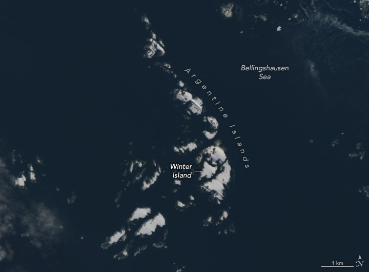
Topped year-round with a layer of ice, Antarctica’s Argentine Islands display a winter-like appearance even in summer. Ice caps are visible across half of the total land area in summer, though the proportion is a bit higher on Winter Island where an ice cap spans about 70 percent of the land.
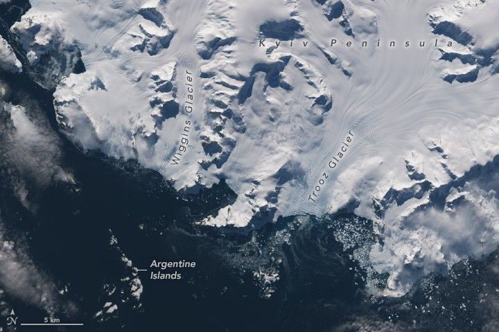
The OLI-2 (Operational Land Imager-2) on Landsat 9 acquired these images on February 16, 2023, during the southern hemisphere’s summer. The wide view (above) shows the island group’s location with respect to the Kyiv Peninsula that projects from the western side of the Antarctic Peninsula.
The summer season provides enough daylight for satellites to acquire natural color images this far south. It is also the time of year when sea ice around Antarctica has melted, making it easier to distinguish the ice-capped islands against the dark-blue Bellingshausen Sea. Several days after these images were acquired, sea ice around Antarctica reached the lowest extent ever observed since the start of the satellite record in 1979. The low-ice trend continued through winter—a time when the ice cover should have been growing at a much faster pace during the darkest and coldest months.
Before there were satellites, knowledge of the region came from the polar explorers and surveyors who visited in person. Winter Island takes its name from the British Graham Land Expedition (1934–1937) that used the island as a winter base in 1935. Expedition members surveyed the region from the air with aircraft and from the ground with dogsled teams, taking advantage of sea ice to travel along the coast. The expedition successfully mapped much of the coastline of Graham Land, the northern portion of the Antarctic Peninsula.
Research operations have since been moved to the neighboring Galindez Island, which is now the site of Ukraine’s Vernadsky Research Base. But visitors with permission can still access Wordie House, the historic base on Winter Island. Visitors might also encounter some of the region’s locals, including the Adélie and gentoo penguins.
References & Resources
- Karušs, J., et al. (2019) Subglacial topography and thickness of ice caps on the Argentine Islands. Antarctic Science, 31 (6), 332–344.
- NASA Earth Observatory (2023, March 16) Antarctic Sea Ice Reaches Another Record Low. Accessed December 22, 2023.
- Secretariat of the Antarctic Treaty Wordie House, Winter Island. Accessed December 22, 2023.
- University of Cambridge, Scott Polar Research Institute (1999) British Graham Land Expedition, 1934–37. Accessed December 22, 2023.
- Wikipedia Winter Island (Antarctica). Accessed December 22, 2023.
NASA Earth Observatory images by Wanmei Liang , using Landsat data from the U.S. Geological Survey . Story by Kathryn Hansen .


