


After setting the all-time record for the lowest recorded pressure in the Atlantic basin as a powerful Category 5 hurricane in the western Caribbean, Hurricane Wilma weakened to a still-powerful Category 4 storm. On October 21, 2005, Wilma slowly crossed over Cozumel as a strong Category 4 hurricane with sustained winds reported at up to 230 kilometers per hour (144 miles per hour) by the National Hurricane Center (NHC). The center of Wilma then drifted over the far northeastern tip of the Yucatan Peninsula delivering torrential rains and strong winds.
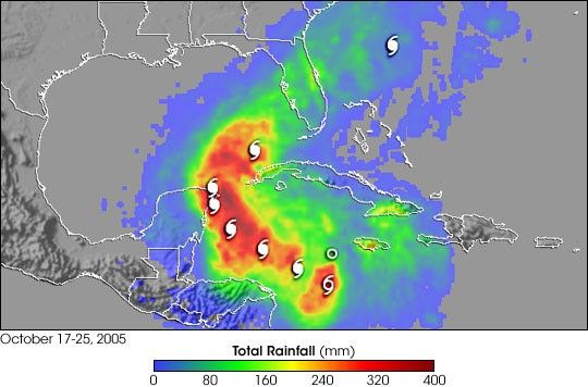
Before being caught up in the westerlies, Wilma stalled out over the Yucatan, resulting in a sustained period of heavy rain and flooding. The rainfall was observed by the Tropical Rainfall Measuring Mission (TRMM) satellite. The TRMM-based, near-real time Multi-satellite Precipitation Analysis (MPA) at the NASA Goddard Space Flight Center provides estimates of rainfall over the global tropics. MPA rainfall totals due solely to Wilma are shown for October 17-25, 2005, with storm symbols marking the storm track. Rainfall totals on the order of 300 to 400 millimeters (12 to 16 inches: darker red areas) are located over the northeastern part of the Yucatan Peninsula.
After drifting over the Yucatan and weakening to a Category 2 storm, Wilma was picked up by a mid-latitude weather system known as a “trough.” The storm accelerated off to the northeast across the southeastern Gulf of Mexico toward Florida, where it made landfall on the morning of October 24 just south of Marco Island. Wilma raced across southern Florida with winds in excess of 160 km/hr (100 mph) in just 6 hours. This quick transit kept rainfall totals down. MPA rainfall amounts over Florida are generally 150 mm (6 inches or less: green areas).
TRMM is a joint mission between NASA and the Japanese space agency, JAXA.
References & Resources
Images produced by Hal Pierce (SSAI/NASA GSFC) and caption by Steve Lang (SSAI/NASA GSFC).


