


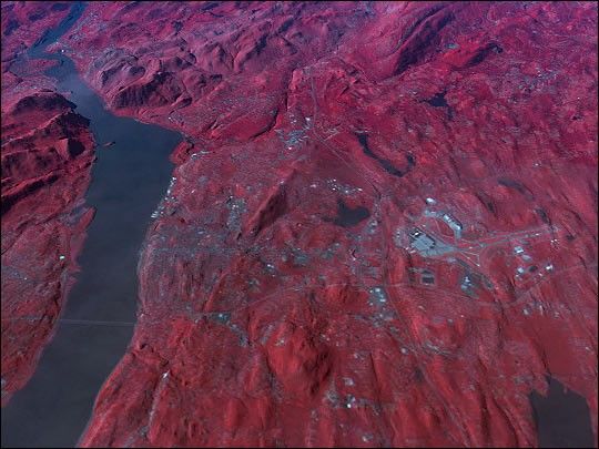
Breakneck Ridge and Storm King Mountain form the northern gateway to the famedHudson Highlands of Southern New York State, 60 miles (97 km) north of New York City.This Advanced Spaceborne Thermal Emission and Reflection Radiometer (ASTER) false-colorimage, captured September 18, 2000, looks south towards the mountains that overlook the Hudson River. Vegetated surfaces appear red, urban areas appear light blue, and water bodies appear dark grey or black. Digital Elevation Model data for topography were overlain to provide this 3-dimensional perspective of the terrain.
The city of Newburgh is in the foregroundand the town of Cornwall lies in thedistance at the base of Storm King Mountain on the western shore of the Hudson. Other prominent features in this scene include:
- The City of Newburgh, where George Washington established his longestresidency during the Revolutionary War. It was here that he founded the Order ofthe Purple Heart, and in 1850 Washington’s Headquarters became the firstRegistered National Historic Landmark in the United States.
- Stewart International Airport, an alternate site for landing thespace shuttle since the airport has one of the longest runways in the UnitedStates.
- I-84 running East-West and crossing the Hudson River at theNewburgh-Beacon Bridge.
- The New York Thruway (I-87) running North-South.
- Cornwall Bay at the base of Storm King Mountain where, legend has it,Henry Hudson anchored in the Half Moon in 1609.
- Schunemunk Mountain near the top center of this scene.
- The United States Military Academy atWest Point can be seen on the western shore of the Hudson near the top leftcorner of the image.
References & Resources
Image by David Olsen, based on data courtesy NASA/GSFC/MITI/ERSDAC/JAROS, and the U.S./Japan ASTER Science Team


