


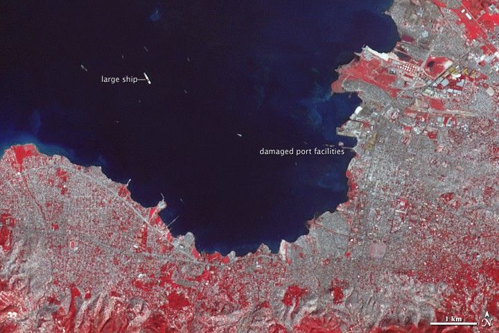
Ships carrying relief supplies and aid were streaming into Port-au-Prince, Haiti, when this image was taken by the Advanced Spaceborne Thermal Emission and Reflection Radiometer (ASTER) on NASA’s Terra satellite on January 21, 2010. The city’s port was badly damaged in the massive 7.0 earthquake that hit the island on January 12. On January 20, one pier re-opened, allowing ships to dock for the first time since the earthquake, said news reports.
The newly reopened pier is the city’s south pier, the narrow strip that juts out into the water in this image. Part of the pier collapsed in the earthquake, but the remaining structure is just stable enough to support a single truck offloading supplies from docked ships, reported CNN.
Tiny streaks of white in the dark blue water are ships. The largest ship in the scene may be the USNS Comfort, a 273-meter- (894-foot-) long U.S. Navy hospital ship that was taking patients by helicopter until a pier could open up, according to Business Week.
Though its capacity is limited, the fragile pier should speed the distribution of food and other supplies to earthquake victims. Prior to January 20, aid had been coming into Port-au-Prince on airplanes arriving on a single runway, said news reports. The ships have a much greater capacity.
Port-au-Prince itself is blue gray in this false-color image. At this scale, the only visible earthquake damage is the shortened pier, but the image does reveal how densely constructed the city was. Plant-covered land is red. Little open, plant-covered ground can be seen in the heart of the city.
References & Resources
- CNN. (2010, January 21). Haiti pier opens, road laid into Port-au-Prince. Accessed January 21, 2010.
- Dolmetsch, C, and Varner, B. (2010, January 21). U.S.-rescued Haitian Victims Treated on Hospital Ship. Business Week. Accessed January 21, 2010.
- Leonard, T. (2010, January 20). Haiti earthquake: damaged port reopens to aid ships. Telegraph. Accessed January 21, 2010.
- Military Seacraft Command. USNS Comfort. Accessed January 21, 2010.
NASA Earth Observatory image created by Jesse Allen, using data provided courtesy of NASA/GSFC/METI/ERSDAC/JAROS, and U.S./Japan ASTER Science Team. Caption by Holli Riebeek.