Suggested Searches

1 min read

Dust Storm in Western China

Instruments:
2012-11-02 00:00:00
November 2, 2012

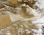
China’s largest, hottest, and driest desert sits in the westernmost part of the country. Filling the Tarim Basin,

Dust blew out of the Taklimakan Desert in early November 2012. The Moderate Resolution Imaging Spectroradiometer (MODIS) on NASA’s Terra satellite captured this natural-color image on November 2, 2012. Part of the Taklimakan Desert appears along the left edge of the image. Dust plumes—thick enough in places to completely hide the land surface—blow away from the basin’s eastern margin.

References & Resources

  • World Wildlife Fund, McGinley, M. (2007) Taklamakan Desert. Encyclopedia of Earth. Accessed November 2, 2012.

NASA image courtesy Jeff Schmaltz, LANCE MODIS Rapid Response Team at NASA GSFC. Caption by Michon Scott.

You may also be interested in:

Stay up-to-date with the latest content from NASA as we explore the universe and discover more about our home planet.

Dust in the “Eye” of the Tarim Basin
3 min read

Satellites have observed episodes of dust swirling across the basin in western China for decades.

Article
A Desert Intersection
4 min read

A colorful ridge and winding glacial meltwater river meet amidst dune fields in western China.

Article
Rings of Rock in the Sahara 
3 min read

In southeastern Libya, Jabal Arkanū’s concentric rock rings stand as relics of past geologic forces that churned beneath the desert.

Article