![Request for Information – Potential [Placeholder for Prize]](https://assets.science.nasa.gov/dynamicimage/assets/science/psd/solar/2023/09/s/solarsystem_0.jpg?w=1024)


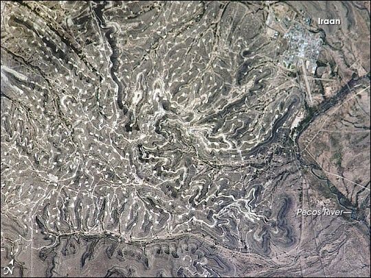
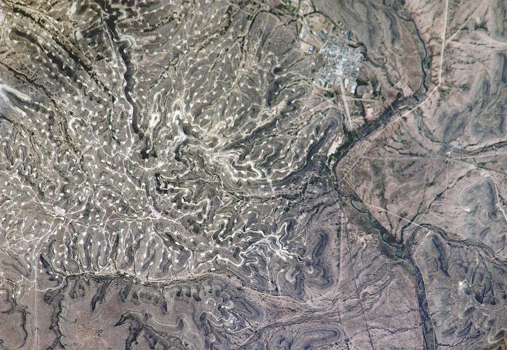
The Permian Basin of west Texas and southeastern New Mexico is one of the most productive petroleum provinces of North America. The area holds one of the thickest deposits of rock from the Permian Period, which lasted from approximately 290 to 251 million years ago. The Basin is a large depression in the bedrock surface along the southern edge of the North American craton, an ancient core of continental crust. The Basin filled with thick layers of sediment during the Paleozoic Era (about 545 to 251 million years ago) as the region was alternately covered by shallow oceans, or exposed as coastal salt flats. The sediments hardened into primarily organic-rich carbonate and minerals such as common table salt. Later activity in the Earth’s crust caused folding of the sedimentary layers, creating ideal conditions for the formation, trapping, and storage of petroleum.
In this astronaut photograph, numerous white well locations and petroleum drilling structures mark the Yates Oil Field in the layered sedimentary rocks of the Permian Basin. The Pecos River bed borders the oil field to the east-northeast. The nearby city of Iraan, Texas, is named for Ira and Ann Yates, the owners of the land where oil was initially discovered in 1926. The city grew in direct proportion to increasing development of the oil field. Today, the town stands out from the underlying sinuous landscape with its sharp angles and straight lines.
The Yates Field started petroleum production in 1926, and by 1995 had produced over 2 billion barrels of oil. While the Yates Field was still actively producing oil and natural gas in 2006, new petroleum discoveries in the area were considered unlikely due to the already-dense well development.
References & Resources
Astronaut photograph ISS013-E-26488 was acquired May 25, 2006, with a Kodak 760C digital camera using an 800 mm lens, and is provided by the ISS Crew Earth Observations experiment and the Image Science & Analysis Group, Johnson Space Center. The image in this article has been cropped and enhanced to improve contrast. The International Space Station Program supports the laboratory to help astronauts take pictures of Earth that will be of the greatest value to scientists and the public, and to make those images freely available on the Internet. Additional images taken by astronauts and cosmonauts can be viewed at the NASA/JSC Gateway to Astronaut Photography of Earth.