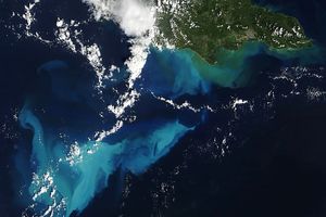
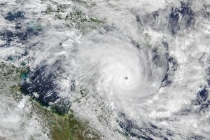
On October 4, 2016, Hurricane Matthew made landfall on southwestern Haiti as a category-4 storm—the strongest storm to hit the Caribbean nation in more than 50 years. Just hours after landfall, the Moderate Resolution Imaging Spectroradiometer (MODIS) on NASA’s Terra satellite acquired this natural-color image. At the time, Matthew had top sustained winds of about 230 kilometers (145 miles) per hour.
Earlier on October 4, temperature data collected by MODIS on NASA’s Aqua satellite revealed that the cloud tops around Matthew were very cold (at least -57° Celsius, or -70° Fahrenheit). Cold cloud tops are known to produce heavy rainfall. The National Hurricane Center called for 380 to 500 millimeters (15 to 20 inches) of rain in Southern Haiti and in the southwestern Dominican Republic.
The northward movement of the storm should bring the center of Matthew over eastern Cuba late on October 4. Dangerous conditions can extend far beyond a storm’s center. According to National Hurricane Center forecasters, Matthew is “likely to produce devastating impacts from storm surge, extreme winds, heavy rains, flash floods, and/or mudslides in portions of the watch and warning areas in Haiti, Cuba, and the Bahamas.”
According to The New York Times, the number of people injured and killed in Haiti had not yet been confirmed. Hundreds of homes were reportedly lost, as well as livestock and crops.
The interaction with land could weaken the storm somewhat, but wind patterns in the upper atmosphere and the warm water in the tropical Atlantic should help maintain Matthew’s hurricane strength for the rest of the week. The specific path of the storm as it approaches the United States is not yet certain. A direct impact on Florida or the Carolinas remains possible.
References & Resources
- NASA Goddard (2016, October 4) NASA Sees Hurricane Matthew Making Landfall in Haiti. Accessed October 4, 2016.
- National Hurricane Center (2016, October 4) Hurricane MATTHEW Advisory Archive. Accessed October 4, 2016.
- The New York Times (2016, October 4) Hurricane Matthew Pummels Haiti With Fierce Winds and Rain. Accessed October 4, 2016.
- Unisys Weather (2016, October 2-4) Hurricane-4 Matthew. Accessed October 4, 2016.
- Weather Underground, WunderBlog (2016, October 4) Matthew Hits Haiti, Their Strongest Hurricane in 52 Years. Accessed October 4, 2016.
NASA Earth Observatory image by Joshua Stevens, using MODIS data from the Land Atmosphere Near real-time Capability for EOS (LANCE). Caption by Kathryn Hansen.

