![Request for Information – Potential [Placeholder for Prize]](https://assets.science.nasa.gov/dynamicimage/assets/science/psd/solar/2023/09/s/solarsystem_0.jpg?w=1024)


November 26, 2017
Waves by Air and Sea
About 250 kilometers from the Antarctic mainland, the ice-capped tops of the Balleny Islands protrude from the Southern Ocean. Located near the intersection of opposing wind and current systems, the archipelago’s three main islands can be battered by weather from all sides.
But when satellites acquired these images on November 26, 2017, the winds were probably not that turbulent, allowing the formation of organized wave patterns in the clouds and at the ocean’s surface. Jan Lieser, a marine glaciologist from Australia’s Antarctic Climate and Ecosystems Cooperative Research Center, noticed the curious patterns while browsing satellite images.
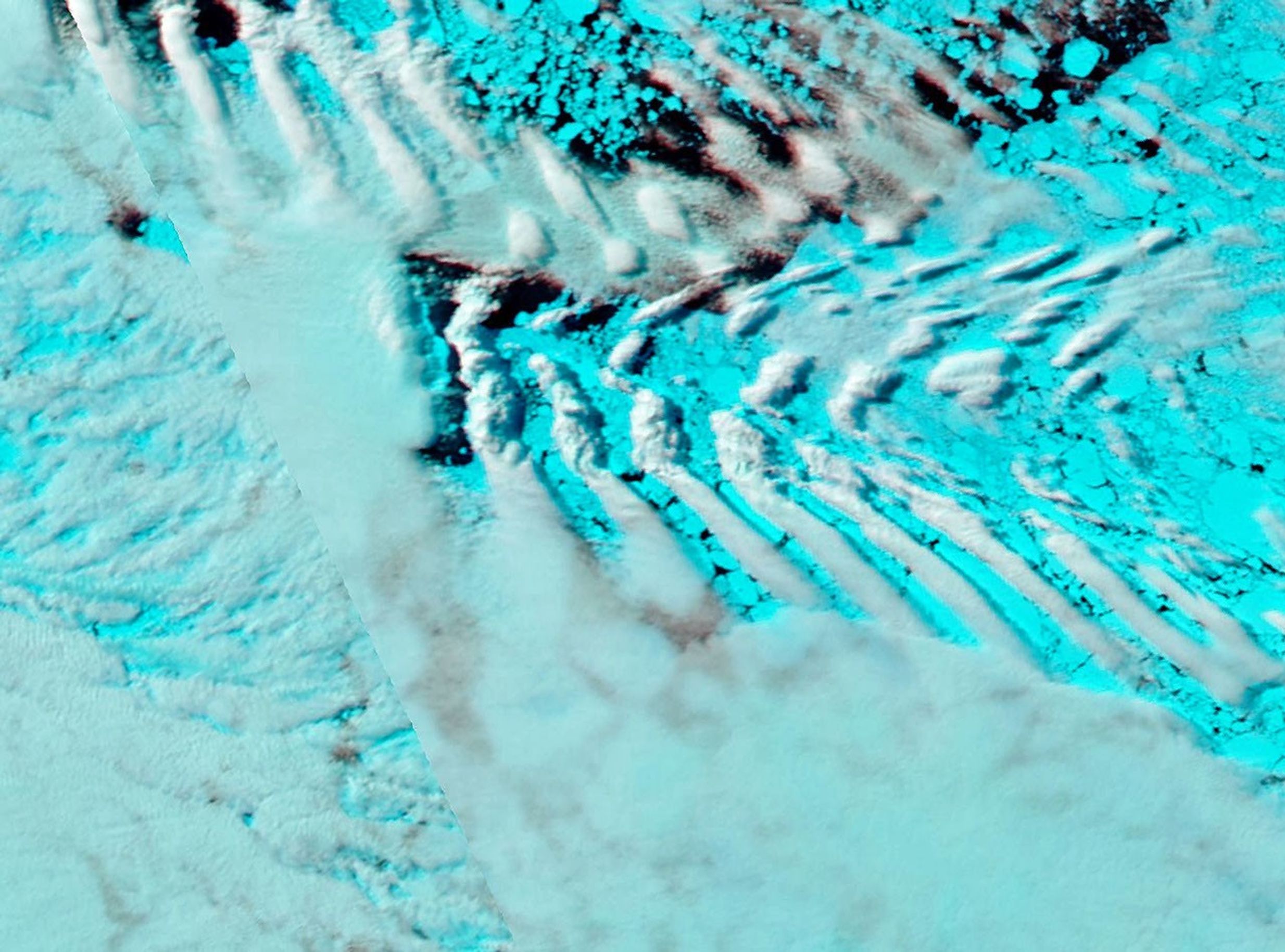
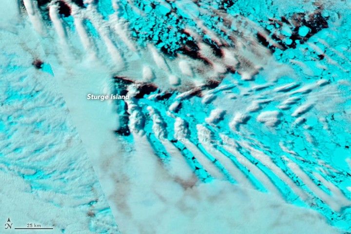
The first image shows a wave pattern in the clouds, as observed by the Moderate Resolution Imaging Spectroradiometer (MODIS) on NASA’s Aqua satellite. The image is false-color, using MODIS bands 7-2-1 to help distinguish clouds (white) from sea ice (blue).
Lieser thinks that a laminar, eastward flow of air hit a speed-bump—Sturge Island—which triggered a low frequency wave pattern to form on the island’s lee side. The flow’s upper layers reached high enough for water vapor to condense and form clouds. The wave ridges are spaced about 15 kilometers apart and persist for about 200 kilometers east of the island.
“The cloud pattern can be compared to a lonesome ship sailing on an otherwise smooth lake or ocean and creating these well-known wave traces behind it,” Lieser said. “Except here it’s the medium (air) that is flowing around the obstacle (island) and not the disturbance (ship) travelling though the medium (water surface).”
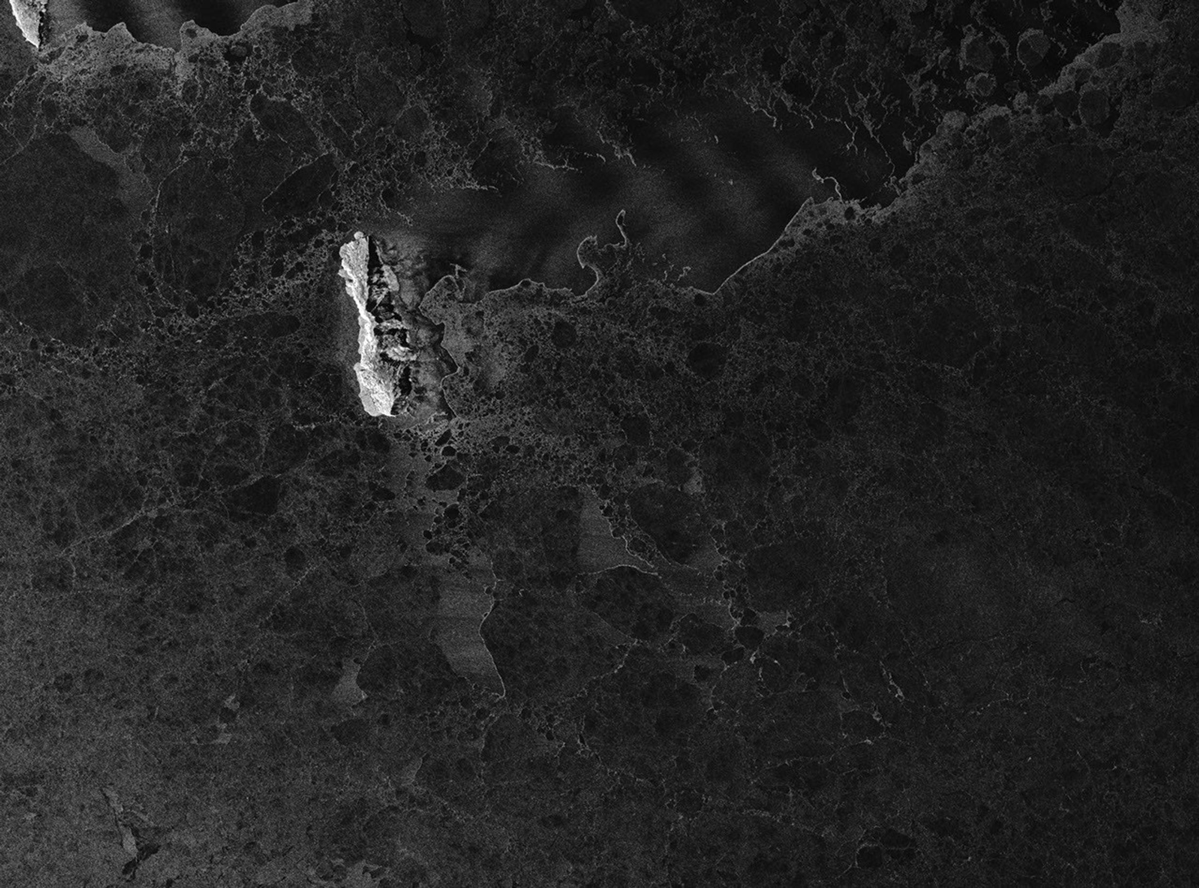
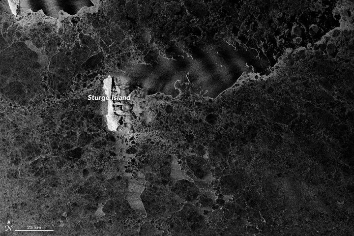
The phenomenon is not entirely unusual. Perhaps more notable is that the pattern also shows up on the ocean surface. Sea surface waves are visible in the second image, acquired on the same day by the synthetic aperture radar (SAR) on the European Space Agency’s Sentinel-1B satellite. SAR can penetrate clouds to map surfaces below.
The grayscale image represents differences in surface roughness. The roughest surfaces, particularly Sturge Island, appear brightest. Smoother surfaces—such as sea ice and parts of the open water—appear dark. Roughness also shows up in a wave-pattern across areas of open water, and in the cracks and openings between the sea ice floes.
Lieser thinks that the same wind that rippled in the sky to form clouds behind the island also came down and roughened the water surface. “If there was a dinghy on the open water east of Sturge Island at the time,” he said, “I suspect the sailor would have experienced long-period trains or rippled water passing by and interchanging with smooth periods on an otherwise calm and pleasant day.”
References & Resources
- NASA Earth Observatory, Images Related to Wave Clouds.
- NASA Earth Observatory (2015, November) Icebergs Make Waves off South Georgia Island.
- New Zealand Geographic (2007, March-April) Baloney Islands; End of the Line. Accessed December 5, 2017.
NASA Earth Observatory images by Joshua Stevens, using modified Copernicus Sentinel data (2017) processed by the European Space Agency and MODIS data from LANCE/EOSDIS Rapid Response . Story by Kathryn Hansen.