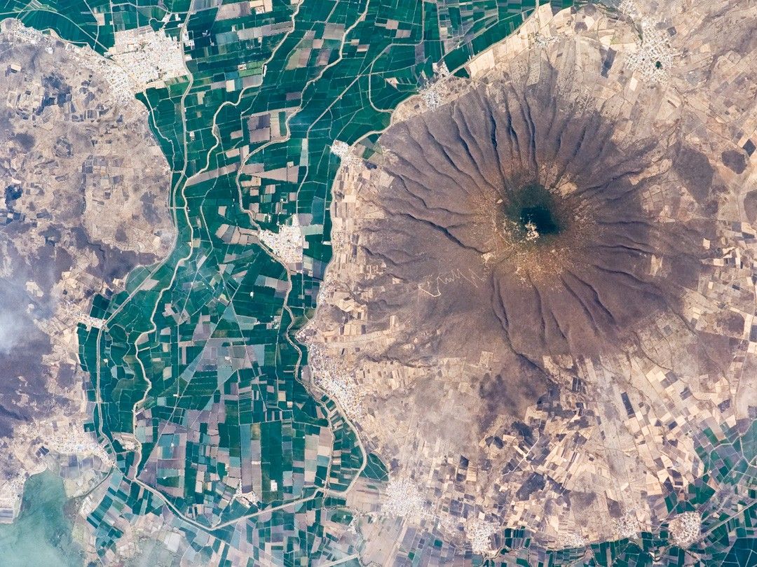

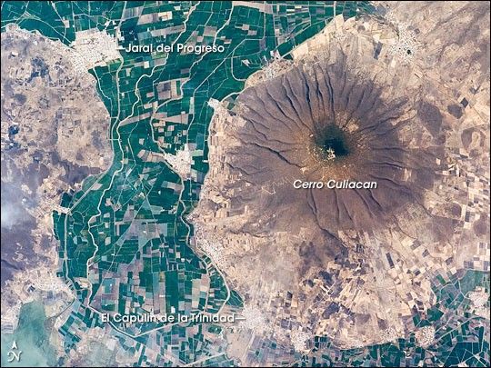
This astronaut photograph highlights Cerro (Spanish for “hill”) Culiacan, part of the 50,000 km2 Michoacán-Guanajuato volcanic field of west-central Mexico. The volcanic field contains over 1,400 known vents, with cinder cones, steep, cone-shaped hills, being the dominant landform. Cerro Culiacan however, is a shield volcano, a more gently sloping mound formed by basaltic lavas. Cerro Culiacan most likely formed during the Pleistocene Epoch approximately 10,000 to 2 million years ago. Shield volcanoes in the Michoacán-Guanajuato field tend to have steeper slopes than similar volcanic structures elsewhere (namely Iceland; this is perhaps due to slightly thicker or higher-viscosity lavas), and the 1,100-meter high Cerro Culiacan is no exception.
The permeable, highly fractured basalt of Culiacan is an important component of the local hydrology. Precipitation that falls on the slopes of the hill swiftly infiltrates the sediments of the valley floor, providing sufficient moisture to support agriculture (green and brown fields at image center) and, in turn, several small cities such as Jaral del Progreso and El Capulin de la Trinidad (light gray regions with street grids). Precipitation has also incised the slopes of Cerro Culiacan with a radial drainage pattern, extending outwards from the peak in all directions much like the spokes of a bicycle wheel.
References & Resources
Astronaut photograph ISS016-E-31086 was acquired on March 3, 2008, with a Kodak 760C digital camera fitted with a 400 mm lens, and is provided by the ISS Crew Earth Observations experiment. The image was taken by the Expedition 16 crew, and is provided by the Image Science & Analysis Laboratory, Johnson Space Center. The image in this article has been cropped and enhanced to improve contrast. Lens artifacts have been removed. The International Space Station Program supports the laboratory to help astronauts take pictures of Earth that will be of the greatest value to scientists and the public, and to make those images freely available on the Internet. Additional images taken by astronauts and cosmonauts can be viewed at the NASA/JSC Gateway to Astronaut Photography of Earth. Caption by William L. Stefanov, NASA-JSC.