


Sentinel-6B Stories
News about Sentinel-6B, an Earth-observing satellite jointly developed by NASA along with U.S. and European partners to observe Earth's ocean, measuring sea levels to improve weather forecasts and flood predictions, safeguard public safety, benefit commercial industry, and protect coastal infrastructure.

Satellite observations of sea surface height indicated that the 2026 event continued to strengthen in early June.
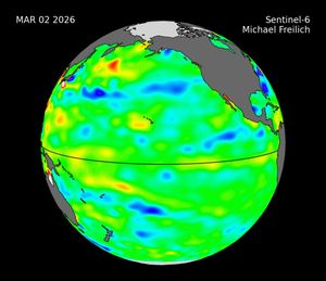
Description Sea level height data from the international Sentinel-6 Michael Freilich satellite collected from March to May 2026 show higher, warmer water moving from the western Pacific Ocean to just off the coast of Colombia, Ecuador, and Peru. This phenomenon…

Sea level data from a satellite launched by NASA and European partners shows that a swell of warm water hundreds of miles wide has arrived in the Pacific Ocean off the coast of South America, a sign that El Niño…

A mild La Niña caused greater rainfall over the Amazon basin, which offset rising sea levels due to record warming of Earth’s oceans. The rise in the global mean sea level slowed in 2025 relative to the year before, an…
Launched in November, Sentinel-6B will track ocean height with ultraprecision to advance marine forecasting, national security, and more. Sentinel-6B, a joint mission by NASA and its U.S. and European partners to survey 90% of the world’s oceans for the benefit…

A weak La Niña emerged in the equatorial Pacific in late 2025, and scientists are watching how it may help shape weather and climate in the months ahead.

A multi-year drought has put extra strain on farmers and water managers in the Middle Eastern country.

About the size of a full-size pickup truck, a newly launched satellite by NASA and its partners will provide ocean and atmospheric information to improve hurricane forecasts, help protect infrastructure, and benefit commercial activities, such as shipping. The Sentinel-6B satellite…
Mission controllers for Sentinel-6B received full acquisition of signal from the spacecraft at 1:54 a.m. EST Monday, Nov. 17. After cross-calibrating its data, Sentinel-6B will take over from Sentinel-6 Michael Freilich, launched Nov. 21, 2020, to monitor sea levels, measure…
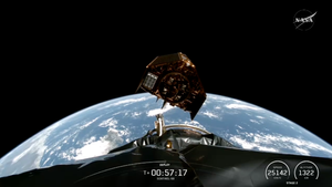
The Sentinel-6B satellite is flying on its own after separating from the SpaceX Falcon 9 second stage. Satellite-6B, part of a mission led jointly by NASA, ESA (European Space Agency), EUMETSAT (the European Organisation for the Exploitation of Meteorological Satellites),…


