Search the Earth Observatory
You may search using a text query below, select the topics you wish to browse on the left, or use the two together to refine your search.
All Earth Observatory Topics
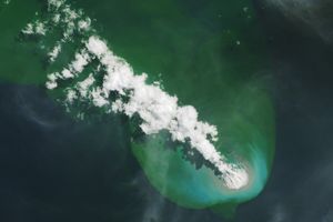
Buoyant volcanic rock fragments from an underwater eruption drifted across the Bismarck Sea and choked island coasts.

The city's metro area has pushed westward since it last hosted World Cup matches in 1986, expanding across a landscape shaped by ancient volcanoes.
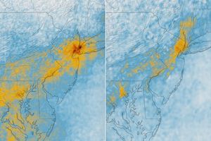
The TEMPO mission helped scientists track morning nitrogen dioxide that contributed to afternoon ozone along the New York–Washington corridor in May 2026.

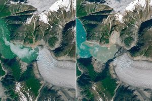
Ice splintered off the southern Patagonia glacier and drifted across a growing glacial lake.
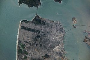
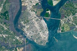
Urban development, green spaces, and maritime activity converge in this Northern California city.

Once below a shallow sea, Jabal al Fāyah now stands above the desert in the United Arab Emirates as a reminder of a watery past and early human survival.

In fire-prone ecosystems in Australia's Northern Territory, prescribed burns are lit to minimize the severity of fires later in the season.

An astronaut’s photo, taken en route to the Moon, reveals our planet and its place in space in a novel way.

The sprawling storm promised to deliver torrential rain across a wide swath of southern Japan.

A wildland fire charred grassland, coastal sage scrub, and chaparral across one-third of the island, the second largest of the Channel Islands.

Satellites observed striking upper-atmosphere phenomena generated by an intensifying tropical cyclone.

Radar data from an agricultural area in South Africa, shown in a vivid color palette, reveal crop types and how they changed during the Southern Hemisphere's growing season.

Wild disturbances are on the rise, while land disturbed by human activity has been decreasing.

The volcano on Indonesia’s Halmahera Island routinely ejects ash, volcanic gases, and volcanic bombs.

Once a month during the full Moon, Landsat 9 turns from Earth to image the lunar surface, helping keep the spacecraft's data accurate and consistent.
In a precursor to Memorial Day, people in Charleston, South Carolina, honored fallen Civil War troops with flowers, songs, and marches at an event at a racetrack on May 1, 1865.

The strongest of several twisters to touch down in the southern part of the state in early May 2026 left a visible path of damaged vegetation.

Satellite imagery shows a surge of new volcanic activity in the ocean near Papua New Guinea.

The blaze spread across the southern side of the second-largest island in California’s Channel Islands National Park.

The glacial lake left a layer of silt and clay in southeastern Manitoba, creating fertile farmland that was divided during 19th-century land surveys and is still farmed today.

An astronaut on the International Space Station was surprised to photograph a shower of light streaking through the darkness while looking out of the Cupola.

A recent analysis revealed where artificial light at night has intensified, as well as where it has diminished.

Spring melt along Alaska’s Kuskokwim River caused ice jams and flooding.

Beaver Island is one in a string of verdant and scenic jewels in a northern Lake Michigan archipelago.
Valley fog gathered in the Victorian Alps while an arch-shaped cloud drifted across Port Phillip Bay.
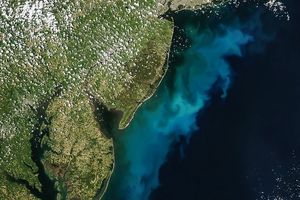
Something is brewing in shallow waters offshore of Delaware, New Jersey, Maryland, and Virginia.
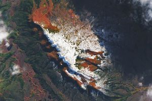
A landslide-triggered tsunami stripped vegetation from the shore of the glacial fjord in summer 2025.

Icy, isolated Peter I Island stirred up a show in the atmosphere off the West Antarctic coast.

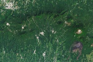
From a geothermal hotspot to the one-time “Lighthouse of the Pacific,” the heat is on beneath the volcanic landscape of western El Salvador.

Scientists relied on satellite data to understand how the Antarctic glacier lost so much ice so rapidly.

Heavy rains from Tropical Cyclone Maila triggered a deadly landslide in the mountains of East New Britain.

As winter turned to spring, the skies over the Gulf of Alaska displayed textbook examples of numerous cloud formations.

Firefighters are battling two destructive blazes in the southern part of the state as drought grips the U.S. Southeast.
The beech forests of southern Patagonia put on vibrant autumn displays.

The mountains of Utah and Colorado are among the areas of the western U.S. that are low on snow and facing water worries in spring 2026.
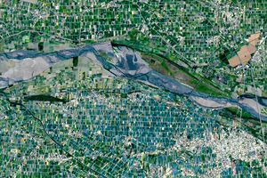
Diversity reigns across the farmland of Yunlin County in southwestern Taiwan—a region that produces an array of crops on small farms.

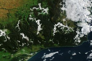
Seasonal fires have darkened skies over Southeast Asia.

On April 6, 2026, shortly before Earth slid behind the Moon from the perspective of Orion, and the spacecraft lost radio signal with mission control for 40 minutes, the Artemis II crew captured this stunning image of Earth setting over…

Along the northeast side of the Capital Beltway in Maryland, green spaces weave through the developed landscape.

The tadpole-shaped islands along the Absheron Peninsula were born by explosive mud volcano eruptions and reshaped by erosion.

The coastal province features striking tropical karst landscapes and sandy beaches alongside a mix of natural land cover and developed areas.

Above-normal precipitation has swollen rivers and damaged infrastructure statewide.

The circular geologic feature in northwestern Africa can be hard to recognize from the ground, but it is obvious when viewed from space.

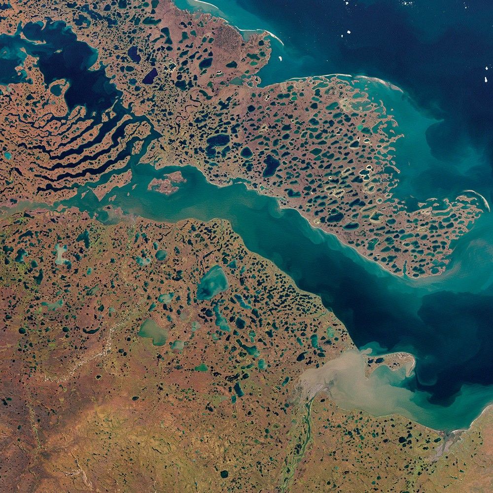
After the Laurentide Ice Sheet retreated from present-day Hudson Bay, rebounding land has revealed striking nearshore topography.

The violent storm aimed at the U.S. Northern Mariana Islands and Guam in mid-April 2026.

Antarctic Iceberg A-23A’s journey ends in fragmentation in the South Atlantic Ocean, after a 40-year lifespan documented by satellites.

An early autumn storm left higher elevations in southern Argentina with a fresh and fleeting coat of white.
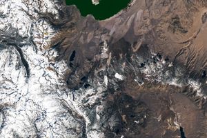
A massive, old caldera and more recently formed craters shape the landscape in the eastern Sierra Nevada.

The state was unusually dry for much of 2025, but the intensity of the drought has ratcheted up since January 2026.
Get the Earth Observatory in your Inbox
Subscribe to our newsletters
We will never share your email address.