


![Request for Information – Potential [Placeholder for Prize]](https://assets.science.nasa.gov/dynamicimage/assets/science/psd/solar/2023/09/s/solarsystem_0.jpg?w=1024)


Description
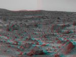
An area of rough Martian terrain is prominent in this stereo image, taken by the Imager for Mars Pathfinder (IMP) on Sol 3. 3D glasses are necessary to identify surface detail. The large rock dubbed "Wedge" is at lower right. The IMP is a stereo imaging system with color capability provided by 24 selectable filters -- twelve filters per "eye."
Click below to see the left and right views individually.
 Left |  Right |
Photojournal note: Sojourner spent 83 days of a planned seven-day mission exploring the Martian terrain, acquiring images, and taking chemical, atmospheric and other measurements. The final data transmission received from Pathfinder was at 10:23 UTC on September 27, 1997. Although mission managers tried to restore full communications during the following five months, the successful mission was terminated on March 10, 1998.


